NorthStar 941X Reference Manual
Northstar 941x: user manual
Hide thumbs
Also See for 941X:
- Operator instructions manual (10 pages) ,
- Addendum reference manual (40 pages)

Related Manuals for NorthStar 941X


Summary of Contents for NorthStar 941X
- Page 1 Reference Manual S O F T W A R E V E R S I O N 2 . 0 5 30 SUDBURY ROAD ACTON, MASSACHUSETTS 01720 (508) 897-6600 Copyright 1994, 1995, 1996 Northstar Technologies P/N GM1100 Doc. Rev D...
- Page 3 The foregoing are the only warranties expressed or implied. No other warranty exists. Northstar assumes no responsibility for any consequential losses or damages of any nature with respect to any products or services sold, rendered, or delivered. Certain Northstar control heads are warranty protected against damage due to...
-
Page 4: Important Notice
IMPORTANT NOTICE Although Northstar products are designed to be very useful navigation tools, they are not substitutes for good seamanship. The prudent navigator should never rely on any single device as the sole source of navigation guidance. Exercise caution and... -
Page 5: Table Of Contents
The Northstar 941X The Northstar 941X Introduction ... 2 Upon First Start-up ... 2 Using This Manual... 3 941X Features ... 4 941X Functions ... 5 Comparing GPS and Loran ... 5 Mounting Basics ... 9 Special Functions... 9 The Display Screen ... 10 Interfacing Capability... - Page 6 Creating Waypoints and Creating Waypoints and Creating Waypoints and Creating Waypoints and Entering Data... 36 Creating Waypoints ... 37 Avoidance Areas ... 39 Waypoint Lists ... 41 Coordinate Options ... 42 Updating Waypoint Coordinates ... 42 Editing Waypoints ... 43 Transferring Waypoints to a PC...
- Page 7 Installation and Interfacing Installation and Interfacing Installation and Interfacing Installation and Interfacing Mounting the 941X ... 100 Wiring the 941X System ... 102 Antenna Location ... 104 DGPS Antenna Coupler (ACU)... 108 Interfacing the 941X ...112 Programming the Output Ports ... 115 Appendix (Specifications) ...
- Page 8 ... 120 ENTENCE DENTIFIERS 800 P ORTHSTAR 800 P ORTHSTAR 800 S ERIES UTPUT LECTRONIC LOTTER ETUP WITH NS B XTERNAL EACON GPS... 8 )... 113 ... 115 A... 123 B... 123 ... 123 ETUP 941X ... 124 ... 125 ECEIVER...
- Page 9 Northstar 941X navi- gator, outlining its various operational functions, in- stallation configurations, and specifications. Use this section to get a quick overview of what the 941X is all about, and how you can use it to your best advantage. Rev. D 1 —...
-
Page 10: Introduction
SC-104 standard (such as the Northstar 8800 DGPS Sensor). When you turn your 941X on for the very first time, you may be greeted Upon First with a flashing exclamation point symbol in the lower right portion of the... -
Page 11: Using This Manual
Press the POSITION key below the left of the screen to return to the main GPS POSITION screen. The 941X is now ready to navigate. (For more on alarms, see page 68. If you wish to proceed directly to navigating with the 941X, skip to page 22.) -
Page 12: Features
Upon using the 941X, you’ll see that you can actually learn to operate the Features system’s various features without constant referral to this manual. After you’ve read through it once, you won't have to refer to it very often again. -
Page 13: Functions
Five keys on the 941X instantly select the most commonly used func- Functions tions, as described below: POSITION displays position coordinates as Speed- and Course-Over-Ground, and Time and Date are also displayed. An alternate position screen plots your position graphically, along with any nearby waypoints and your track history. - Page 14 300 feet of your intended position 95% of the time, and be- yond that area approximately 5% of the time. At first, this was accepted by most end-users as an inevitable part of GPS, a tradeoff against its global availability. But it didn’t meet the Coast Guard’s requirement of 8- 20 meter accuracy for navigating harbors.
- Page 15 In very good coverage areas, loran can typically get you to within 50 feet (or roughly 14 meters) of your previously-visited target. On the other hand, at its very best, uncorrected GPS with SA enabled will get you to within 300 feet (100 meters) of your intended destination. Obviously, uncorrected GPS—with variations of up to 300 feet in displayed posi-...
-
Page 16: Figure 1-Max. Position Variances With Uncorrected Gps
GPS—you could be as much as 600 feet from your expected position. This will be especially apparent when using the 941X’s plotter screen (without DGPS), where you may see your boat’s plotted position appear to wander around within an area up to 600 feet in diameter (see Figure 1 below). -
Page 17: Mounting Basics
The Beacon Receiver antenna (if installed) should be mounted fairly high, like a loran antenna. Refer to “Mounting the 941X,” on page 100, for de- tails. -
Page 18: The Display Screen
GPS. See page 30 for further details on using loran TDs. plotter functions The 941X’s plotter provides a picture of your position, and of what is around you. Nearby waypoints, avoidance areas, and a lat/lon grid may be displayed along with an image of your boat. -
Page 19: Interfacing Capability
It also features an RS-232 port for input or output of SC-104 DGPS corrections, and way- point/route or software program loading from a PC. The 941X can be interfaced to a wide variety of devices, including autopilots, plotters, ra- dars, etc. - Page 20 Page 12 1 — Introduction 1 — Introduction 1 — Introduction 1 — Introduction Rev. D...
-
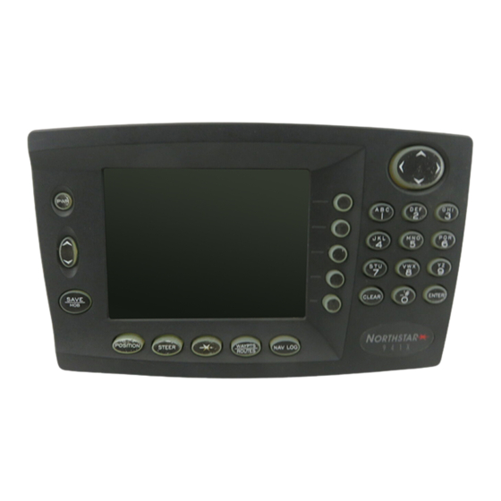
Page 21: Using The Controls
Using the Controls Special Display Windows HIS SECTION describes each of the Northstar 941X's controls. Use this section for learning what each con- trol does and for an overview of using its various functions. Rev. D 2 — Using the Controls 2 —... -
Page 22: Power Key
(located below the dis- play screen). Return the 941X to the factory for service. To turn the 941X off, press the POWER switch and hold it in for at least one full second until the unit turns off. -
Page 23: Save/Mob Key
The waypoint’s 3-digit number will “wrap around,” or revert, to –S001– when the 941X has reached the limit you set using the MAX SAVED WPT # function under DISPLAY OPTIONS (see page 80). -
Page 24: Function Keys
The five function keys located below the display screen control what the Function Keys 941X is doing. Any function key may be pressed at any time to display the information you need to see. POSITION key... -
Page 25: Menu Keys
The function of each key is labeled on the screen, and pressing the key performs the displayed function. A large cursor pad in the upper right corner of the 941X allows you to Cursor Keys move the flashing cursor on the display screen to the data you want to display or change. -
Page 26: Special Display Windows
When the 941X is expecting letters to be entered, such as waypoint names and descriptions, the operation is slightly different. Each key is labeled with three letters (or other special characters) and a digit. - Page 27 Information windows always appear with the word “INFO ” in a small box. question Question windows appear when the 941X needs to know more about windows what you want to do. A question mark will always appear in this type of window.
- Page 28 Page 20 2 — Using the Controls 2 — Using the Controls 2 — Using the Controls 2 — Using the Controls Rev. D...
-
Page 29: Basic Navigation
For those who no longer have a loran receiver, but wish to view their position in loran TDs, the 941X can convert GPS coordinates into Phantom Loran coordinates. Rev. D 3 —... -
Page 30: Displaying Position, Heading & Speed
(Loran coordinates may be obtained from a loran receiver connected to the 941X, or may be calculated by the 941X from the GPS position coor- dinates.) The position plotter screen is a “north-up” display, and provides an over- Position Plotter all view of the surrounding area and all nearby waypoints. - Page 31 The boat image shows your actual direction of travel over the bottom, not the direction your boat is headed. If your boat is not moving, the Course-Over-Ground cannot be determined by the 941X, and the direction of the boat on the screen has no meaning.
- Page 32 Press ENTER when done, or CLEAR to restore the field to its original value. The 941X can store up to 900 points in its track, so the maximum length of the track depends on how often points are stored.
-
Page 33: Using Gps
Pressing the CLEAR TRACK menu key clears the track history displayed on the screen. Press the RETURN menu key to go back to the plotter screen. Your 941X contains an internal GPS receiver which is used as the pri- Using GPS mary source of position data. -
Page 34: Using Dgps
Page 26 NOTE The 941X’s speed and course readings are the result of instan- taneous measurements derived from satellite signals. GPS speed is updated every second. However, you may average these readings by changing the “GPS speed averaging”... - Page 35 To display more information about signals received from the GPS satel- lites, press the SATS menu key on the GPS position screen. A screen is displayed showing the received Signal-to-Noise Ratio for each satellite, and a map indicating where the satellites are currently located in the sky (the 12-channel GPS SATS screen is shown on the next page).
- Page 36 Page 28 NOTE On five-channel 941Xs, the last bar at the bottom of the screen will sometimes “jump” around once per second as the 941X receiver sequences among other satellites. ACCURACY: The estimated accuracy of the GPS system to be...
- Page 37 The lower part of the screen shows three bar graphs: 1. SNR 2. SIGNAL 3. NOISE At the bottom of the screen a summary of DGPS operation is displayed. You may see one of the following messages: Rev. D SNR The Signal to Noise Ratio (SNR) is a good overall measure of overall signal quality, and should be as high as possible.
-
Page 38: Using Loran
Press the RETURN menu key to return to the previous screen. Using Loran If you have a loran receiver connected to your 941X, you can navigate using loran coordinates as well as GPS. Just select loran as the source of navigation data, as described below, and you’re on your way. - Page 39 SET GRI menu key on the LORAN POSITION screen. You must set this to correctly match the GRI being used by your loran receiver for the 941X to accurately convert the loran’s TDs to latitude/longitude position fixes. loran warnings Loran warning indicators obtained from any Northstar 800 series loran receiver are displayed to the right of each TD.
-
Page 40: Using Phantom Loran
GPS lat/lon coordinates to loran TDs, enabling you to dis- play your position as TDs. Phantom Loran The 941X may be used to simulate full operation of a loran receiver. Po- operation sition coordinates may be displayed as TDs, and all navigation functions may be used as if the unit were actually receiving loran signals. - Page 41 TD coordinates obtained directly from ac- tual loran signals. In most areas, errors should not exceed 0.2 microsecond. However, larger errors are possible in areas for which the 941X does not contain accurate, factory-programmed ASF correction points. selecting...
- Page 42 TDs. Press the up and down cursor keys to display the available GRIs one at a time. When the GRI is correct, press ENTER. checking GPS Press the SAT INFO menu key to check on the received GPS satellite status status, as described on page 27.
-
Page 43: Routes
Creating Waypoints and Updating Waypoint Coordinates Transferring Waypoints to a PC In this section, we’ll learn how to create waypoints, use them to form routes, and change them as necessary. Rev. D 4 — Creating Waypoints and Routes 4 — Creating Waypoints and Routes 4 —... -
Page 44: Entering Data
Press ENTER when all the characters are correct. Here are some of the things you can do with waypoints using your 941X: 1. Navigate to a point in one step (a “quick start” waypoint) 2. -
Page 45: Creating Waypoints
Waypoints to the following is displayed: To store a waypoint permanently in the 941X's memory, first assign it a name. The name can be from 1 to 6 characters long, and it must differ by at least one character from any other waypoint name in the unit's mem- ory. - Page 46 CLR to erase any characters from the line and start over; otherwise, press ENTER when the screen is correct. If you are entering coordinates as distance and bearing, the 941X nor- mally asks for these coordinates relative to your current position, known as “–HERE–.”...
-
Page 47: Avoidance Areas
The 941X will display each avoidance area as a circle the size of the warning radius you entered. For new waypoints, enter a distance in the WARN RADIUS box at the bottom of the NEW WAYPT screen. - Page 48 As a precaution, once you have designated a waypoint as an avoidance area, the 941X does not allow you to navigate to it. avoidance area Once you have designated a waypoint as an avoidance area, the 941X will alarm alert you upon penetration of that area.
-
Page 49: Waypoint Lists
Waypoints contained in your 941X can be displayed in any of four ways. Waypoint Lists Press the WAYPTS/ROUTES function key, then the WAYPT LIST menu key to display waypoint lists. Use the NEXT LIST menu key to se- lect the list that is best for your current situation. Each press of the NEXT LIST menu key displays a waypoint list in the following order: ALPHA, SAVED, AVOID and LOCAL, then starting again at ALPHA. -
Page 50: Coordinate Options
Coordinates expected. The 941X has a special feature that allows you to easily re- calibrate the waypoint by setting its coordinates to your precise position. You can also use this feature to convert approximate loran TD coordi- nates to precise GPS coordinates. -
Page 51: Editing Waypoints
COORD menu key to correct the waypoint’s coordinates, as described in the previous section. Press the ERASE menu key to permanently erase the waypoint from the 941X’s memory. (Note: You can’t erase it if it is used in a route—you must first erase it from the route. See “Changing a Route”... -
Page 52: Transferring Waypoints To A Pc
If you store a large number of waypoints or routes in the 941X, or if your Transferring waypoints are the only records you have of important locations, you Waypoints to a should consider making a copy of them by transferring them into a per- sonal computer using special transfer software (provided by a third party vendor) and a Northstar loader cable (part #1100-LC). - Page 53 Press the NEW menu key. A screen is displayed asking you to enter the name of the new route. route name Enter the name of the new route using the keypad and cursor arrow keys, as described on page 36, and press ENTER. The NEW ROUTE way- points screen will be displayed, ready for you to begin selecting way- points to add to the route.
- Page 54 Press ENTER. The new waypoint is now part of the new route and stored among the waypoint lists in the 941X’s memory. Page 46 Press the NEXT LIST menu key, if you wish, to select different...
-
Page 55: Saving A Route
The 941X's SAVE ROUTE function makes this a very simple proc- ess. In summary, you first tell the 941X that you wish to save a route as you travel, then press the SAVE/MOB button as you pass each waypoint, and then tell the 941X to stop saving the route when you come to the end of the route. - Page 56 Press the SAVE menu key on the lower right of the display to instruct the 941X to begin saving a route automatically. A screen is displayed asking you to enter the name of the new route to be saved. route name Enter the name of the new route to be saved, using the keypad and cur- sor arrow keys, and press ENTER.
- Page 57 You can access any of the 941X’s navigating functions while you are sav- ing a route automatically, with the exception of editing the route you are presently saving.
-
Page 58: Changing A Route
To make a change to a route stored in the 941X's memory, use the EDIT Changing a ROUTE function. Press WAYPTS/ROUTES and then the ROUTE LIST Route menu key to display the ROUTES screen. Use the up or down cursor keys to point to the route you wish to change. - Page 59 941X’s memory, following but these changes do not appear in the copy of the route the 941X is fol- lowing. " To make these changes take effect, you must start following the route again (see page 59).
- Page 60 To plot an overhead view of the route, press the QUICK PLOT menu key. Page 52 4 — Creating Waypoints and Routes 4 — Creating Waypoints and Routes 4 — Creating Waypoints and Routes 4 — Creating Waypoints and Routes Rev.
- Page 61 Waypoint and Route Navigating to Waypoints Navigating Along Routes Restarting the Course Line In this section, we’ll begin navigating to specific waypoints and along routes, and show you how to get back on course, or follow a new course line to your destination. Rev.
-
Page 62: Quick-Start Waypoint
Coordinates may be entered as: The coordinates you enter will be stored in the 941X's memory as a way- point named “–QUIK–.” This waypoint’s coordinates will be overwritten the next time a QUICK waypoint is entered. -
Page 63: Navigating To Waypoints
To navigate to a waypoint already stored in the 941X, first display it us- Navigating to ing one of the four waypoint list screens: press WAYPTS/ROUTES, then Waypoints the WAYPT LIST menu key. Use the up and down cursor arrow keys to move the large arrow on the left of the screen so that it points to the waypoint you want to navigate to. -
Page 64: Other Information
choosing a The first STEERING screen is a traditional display showing cross-track steering screen distance at the bottom of the screen (how far off your intended course line you may be) combined with numeric information depicting the dis- tance to your destination waypoint, your present bearing to that way- point, your present SOG, and your present COG. - Page 65 In the first steering screen above, a line extends from the data box in the center of the screen to a menu key. Each press of the menu key changes the data displayed in the box among three choices, as follows: off-course The lower part of the screen displays your off-course distance, using a distance...
- Page 66 As you pass a waypoint while following a route, the image of the boat may swing around vigorously as it points to the way- point you are passing. When the 941X switches to the next waypoint, the boat image will snap back to pointing straight ahead.
-
Page 67: Navigating Along Routes
To follow a route that has been stored in the 941X’s memory, press the Navigating WAYPTS/ROUTES key, then the ROUTE LIST menu key. Use the cur- Along Routes sor keys to select the route you wish to follow, and then press the GO menu key. - Page 68 To start following the route, select the waypoint or leg you want to start on, press the GO menu key, then ENTER. planning ETA to Before you actually start the route, you can display planning information any waypoint about the route in the GO ALONG ROUTE screen. An estimate of the time required to travel to the selected waypoint is displayed near the top.
-
Page 69: Restarting The Course Line
distance & The distance and bearing of each leg are displayed near the center of the bearing screen. waypoint To display the coordinates of each waypoint in place of the name and de- coordinates scription, press the NAME/COORD menu key. quick plot To plot an overhead view of the route, press the QUICK PLOT menu key. - Page 70 To restart your course line from your present position, display the NAV LOG screen or the POSITION PLOTTER screen. Press the RESTART menu key, then the ENTER key. The 941X will recompute the course line to extend from your present position directly to the next waypoint, re- setting your cross-track error to zero.
- Page 71 The NAV LOG Function Adding Waypoints to the Trip The Northstar 941X’s NAV LOG function provides a quick and easy way to check on your progress along a trip, and to make changes to it while you travel. Rev. D 6 —...
-
Page 72: What Navlog Does
Does your route. When you navigate to a waypoint or along a route from the 941X’s memory, the string of waypoints are copied into the NAV LOG, which acts as a kind of “scratchpad” for monitoring your progress. You can modify NAV LOG’s route in any way you want without affecting the original route, which remains safely stored in the unit’s memory. -
Page 73: Logging Your Trip
Any waypoints added to the trip in NAV LOG are not perma- nently appended to the route in the 941X’s memory. To make permanent changes to the route, you must use the EDIT ROUTE functions, as de- scribed on page 50. -
Page 74: Adding Waypoints To The Trip
You can easily read the direction of the next leg of your trip from this display. Press the NAV LOG key to display the waypoints of your current trip. To Adding add a waypoint to the end of the trip, press APPEND WAYPOINT. A list Waypoints to of the waypoints stored in memory is displayed. - Page 75 Other Special Functions Internal Differential Beacon Receiver This section covers several special functions that enable you to: change the 941X’s audible alarms and screen ap- pearance; navigate using the unique TideTrack™ feature; get the most out of the high-precision positioning capabili- ties of your internal or external Differential GPS (DGPS) receiver.
-
Page 76: Alarms
The Northstar 941X has a number of automatic alarms that can alert you Alarms of special situations. For example, when you are approaching a waypoint, the 941X signals you with a distinctive “beep” and a flashing exclamation point symbol on the screen. - Page 77 The most recent instance of an alarm type (waypoint, communications, avoidance area, anchor and cross-track alarms) is retained in the 941X’s memory. This is helpful for viewing those “auto-clear” alarms that you may have been unable to acknowledge before the flashing exclamation symbol was automatically cleared.
- Page 78 ON at the ALARMS & BACKLIGHT screen. anchor watch The anchor watch feature of the 941X will sound an alarm if the unit de- tects that the boat has moved a specified distance away from an initial position.
-
Page 79: Screen Backlighting
0.01 nm. " NOTE: Keep this distance very small because the 941X will automatically begin to sequence to the next waypoint when you come within the arrival distance you have set for the current waypoint. - Page 80 You may display tide information for any of over 3000 NOAA tide sta- nearby tide tions stored in the 941X. You can select from any of the nine tide stations station closest to your present position, or you may select from any of nine tide stations closest to any waypoint stored in the 941X.
- Page 81 ENTER twice to return to the TIDE TRACK screen and display the tides for that station. choosing a The 941X will display NOAA tide stations within 100nm of any waypoint distant tide stored in its memory. (You can always store a waypoint just for the pur- station pose of locating tide stations in that area, at a later date.
-
Page 82: Internal Differential Beacon Receiver
Use the up or down cursor arrow keys to point to the desired waypoint, and press ENTER. The 941X will search for, and present, the nine closest tide stations to this waypoint. Now, use the up and down arrow keys to point to the desired station, and press ENTER twice to return to the TIDE TRACK screen and display the tides for that station. - Page 83 These corrections are used by your 941X to improve its position accuracy to 10 meters—or better—with 2-5 meters accuracy commonly available. Differential corrections are invaluable when navigating in narrow or congested areas (such as ports and waterways), or whenever extreme ac- curacy is required for locating a precise area (retrieving lobster pots, re- turning to a diving spot, etc.).
- Page 84 DGPS data can be interrupted by bad weather, severe thunderstorms, extreme distance from the beacon, etc. You may allow the 941X to navigate for a set period of time using this old data with no DGPS interruptions. To change the data “timeout” period, refer to page 89.
- Page 85 Customizing the 941X his section explains the various options available to you for customizing the way your 941X displays informa- tion to you, computes navigation data, and “talks” to other devices. Each option is changeable at any time, according to your specific needs.
-
Page 86: Display Options
Press ENTER to use the new time zone. To access the 941X’s display options, press the STAR key until you dis- Display Options play the USER CUSTOMIZATION screen. - Page 87 You may choose between nautical miles and knots, kilometers and kilo- meters per hour, or statute miles and miles per hour, for the 941X’s vari- ous distance and speed displays, respectively. " To change this option, press EDIT, then use the cursor keys to scroll among the available choices.
- Page 88 (DISPLAY OPTIONS) (DISPLAY OPTIONS) (DISPLAY OPTIONS) You may adjust the precision of the 941X’s latitude and longitude posi- tion displays from degrees, minutes and seconds (two digit places, or .XX), to degrees, minutes and thousandths of minutes (three digit places, or .XXX...
- Page 89 To change the maximum saved waypoint number: The 941X will now automatically number your saved waypoints up to the value you have set, at which point it will then begin to overwrite previ- ously-saved waypoints with your new ones. owner’s message...
-
Page 90: Navigation Options
(NAVIGATION OPTIONS) (NAVIGATION OPTIONS) (NAVIGATION OPTIONS) source The 941X’s position displays and navigation to a waypoint are based on position information obtained from any one of four available navigation sources: " Use the NAVIGATION SOURCE option to select which source is to be used. - Page 91 Compasses naturally point to the magnetic north pole, which is several hundred miles from the Earth’s actual north pole. The difference be- tween the two angles is known as magnetic variation . The 941X offers you the option of choosing from True lates variation automatically, according to your location), and Manual (from 0°...
- Page 92 You have “arrived” at a waypoint when you enter the circle determined by the waypoint’s ARRIVE RADIUS, or when you pass the perpendicular of the end point of the current leg you are following. The 941X will signal that you have arrived by flashing the alert symbol (flashing exclamation point) in the lower-right portion of the display.
- Page 93 When your choice is displayed, press ENTER. (The complete listing of 941X datums is found at the end of this chapter, be- ginning on page 94.)
- Page 94 NOTE The CROSS-TRACK FULL SCALE display formats apply only to the STEERING screen, and not to the 3-D steer screen. 8 — Customizing the 941X 8 — Customizing the 941X 8 — Customizing the 941X 8 — Customizing the 941X...
-
Page 95: Receiver Options
The time over which your speed is averaged by the 941X may be selected with this function, with values between two and ten seconds available. - Page 96 If your 941X either contains an internal beacon receiver or is interfaced beacon baud to an external Northstar beacon receiver, you can set the 941X to control rate the beacon receiver automatically or control it manually yourself. Under automatic control, the receiver scans for nearby beacon transmitters and uses the one having the best signal for your area.
- Page 97 DGPS corrections if no new corrections are being received (due to bad weather, extreme distance from beacon, etc.). If this time period elapses with no new DGPS data received, the 941X reverts to standard GPS navi- gation, and displays OLD CORRECTIONS as the DGPS status.
-
Page 98: Port Setup Options
Connection is made through any of three data transmission “ports” lo- cated on the back side of the 941X: two NMEA ports and one RS-232 port. Each is capable of operating independently, thereby giving you the flexibility of driving (or “talking to”) three separate devices simultane- ously. -
Page 99: Service Options
(SERVICE INFORMATION) (SERVICE INFORMATION) In addition to being affixed to the back of the unit, your 941X’s serial number is permanently programmed into memory at the factory. Serial numbers ending with the letter “D” indicate that the unit contains an internal DGPS beacon receiver. - Page 100 (SERVICE INFORMATION) (SERVICE INFORMATION) soft ver If your 941X has an internal beacon receiver installed, this line will con- tain a number indicating the software revision of the beacon receiver. If none is installed, the line will be blank. beacon rx...
- Page 101 (SERVICE INFORMATION) (SERVICE INFORMATION) A built-in test feature allows you to verify the integrity of your 941X key- pad. Each key you press here will be identified in the KEY PRESSED display box. This function works for all but the POWER, CONTRAST...
-
Page 102: Geodetic Datum
When you come to the datum you desire, press ENTER, or press CLEAR to leave the datum choice unchanged and exit the edit function. The following chart lists the datums available in your 941X: ADI_MN ADINDAN Mean—Africa ADI_E ADINDAN—Ethiopia... - Page 103 CL1866 CL1880 CL1866 AIRYM EVRSTM CL1866 CL1880 CL1866 CL1866 CL1880 CL1880 CL1880 8 — Customizing the 941X 8 — Customizing the 941X 8 — Customizing the 941X 8 — Customizing the 941X INTL -116 -333 INTL -320 -494 INTL -234...
- Page 104 INTL INTL CL1866 INTL INTL INTL INTL INTL INTL INTL B1841N SA1969 8 — Customizing the 941X 8 — Customizing the 941X 8 — Customizing the 941X 8 — Customizing the 941X -247 -148 -249 -156 -231 -196 -425 -169...
-
Page 105: Table 1-Datum List
EVRST B1841 B1841 B1841 B1841 INTL CL1880 HOUGH WGS-72 INTL Table 1—Datum List 8 — Customizing the 941X 8 — Customizing the 941X 8 — Customizing the 941X 8 — Customizing the 941X -499 -249 -104 -689 -128 -123 -128... - Page 106 Page 98 8 — Customizing the 941X 8 — Customizing the 941X 8 — Customizing the 941X 8 — Customizing the 941X Rev. D...
- Page 107 DGPS Antenna Coupler (ACU) 108 Programming the Output Ports 115 This section includes all the information needed to install your 941X and interface it to other equipment on your boat. Rev. D 9 — Installation and Interfac c c c ing 9 —...
-
Page 108: Mounting The 941X
Choose a mounting location for the 941X that allows good visibility of the screen, is within comfortable reach, and provides a reasonably direct path for running the required electrical cabling. - Page 109 The shipping carton contains the following components: Save all packing material in the event it is necessary to return the unit to the factory for repair or evaluation. Your 941X should only be shipped in a properly designed carton with packing material.
-
Page 110: Figure 2-Yoke Mount Drilling Dimensions
Replacement of the fusible link should be performed only by a qualified electronics technician. Access to the link is gained by removing the 10 outer case screws to open the 941X, then removing the 4 computer board screws and lifting the computer board out to expose the I/O board below. -
Page 111: Figure 3-Rear Connectors
We strongly recommend (as a good safety practice) that your 941X be connected to an external circuit breaker or fuse located near the battery or breaker box. The internal fuse is designed to protect the 941X itself; the external fuse or breaker is intended to protect the vessel wiring and prevent electrical fires. -
Page 112: Antenna Location
Location receive both GPS and DGPS signals (#AN190 combo antenna). The antenna is a vital link between the 941X receiver and the outside world. Aesthetics and easy access should be secondary to providing strong and reliable GPS signals to the 941X receiver. You should select a... -
Page 113: Figure 4-941X Gps-Only Antenna (An145 & An150)
Tools needed: GPS-only antenna The RG-59 cable supplied with your 941X has one TNC connector at- tached to the antenna-end of the coax. Connection to the antenna itself involves the following steps: Rev. D 3. 00 . 91 1. - Page 114 50 feet! The cable “splitter” box supplied with the AN190 combo antenna should be located near the 941X for convenience, but may be situated virtually anywhere along the length of the maximum 100 feet of RG-59 GPS cable,...
-
Page 115: Figure 6-Stripping The Coax Cable Jacket
Keep the antenna at least six feet away from objects that can “shade” GPS or differential signals. GPS antenna Avoid tight bends when installing any antenna cable. Be sure to fasten cables the cable along its length to avoid chafing or whipping of any kind. -
Page 116: Figure 7-Flared Cable Braid
3) Place center contact onto center conductor so that it butts against the 4) Figure 8 If poor GPS SNR readings are obtained after the 941X has been running for several minutes, check that you have the proper length of cable matched to the type of antenna (active, passive, or combo), verify the quality of the antenna location, and the quality of the connectors. - Page 117 The grounding system is an equal partner with the antenna in producing quality signals for the 941X DGPS beacon receiver. Essentially, the ground system provides a secure connection to a large electrical mass; ideally, the earth itself. On a vessel, this means establishing electrical contact with the sea.
-
Page 118: Figure 9-Acu Assembly
WHENEVER ANY ANTENNA IS DISCONNECTED FROM ON-BOARD EQUIPMENT, BE SURE TO GROUND THE ANTENNA SHIELD IN ORDER TO DISCHARGE EXTREMELY LARGE STATIC VOLTAGES THAT CAN QUICKLY BUILD UP ON AN UNGROUNDED ANTENNA SYSTEM. THESE VOLTAGES ARE HAZARDOUS TO PERSONNEL AND EQUIPMENT! Page 110 Figure 9—ACU Assembly WARNING... -
Page 119: Figure 10-Pl 259 (Uhf) Connector
GPS Both ends of the differential beacon receiver antenna cable terminate in antenna cable UHF connectors. Follow the assembly instructions in Figure 10 for pre- connectors paring UHF connectors. For best results, coat these connectors with sili- cone gel to retard corrosion. -
Page 120: Interfacing The 941X
(one inch diameter, 14 threads per inch). The 941X is easily interfaced to other equipment as described below. Interfacing the NMEA 0183 is the most common interface data format used with 941X 941X installations. It is a widely-accepted standard of data transfer between most all types of marine electronics today, enabling completely different instruments to “speak”... -
Page 121: Figure 11-Interface Connector ( Mating Side )
The 941X has two programmable NMEA input/output ports and one RS- 232 input/output port that you can customize for outputting data to other instruments, and two ports for inputting data from other devices. connector pin (PORT SETUP OPTIONS) (PORT SETUP OPTIONS) -
Page 122: Table 2-Interface Connector Pins
EXTERNAL SAVE IN 200 PPNM OUT (Pulses Per Nautical Mile) 200 ppnm The Northstar 941X provides an open-collector transistor output (on pin output 14) which is programmed to produce 200 pulses per nautical mile for those devices requiring this output. -
Page 123: Ppnm Output Block Diagram
The SETUP function described below allows the selection of the Ports specific 0183 sentences that will be transmitted by the 941X. Press the STAR key until you see the USER CUSTOMIZATION menu. Press the menu key marked PORT SETUP OPTIONS, then press the PORT 1 SETUP or PORT 2 SETUP key. -
Page 124: Table 3-Port Setup Options
(PORT 1 / PORT 2 SETUP) (PORT 1 / PORT 2 SETUP) The 941X will output navigation data in any of several standard formats (or one user-customizable sequence), as required by the receiving, or “listener” device. Upon pressing the EDIT menu key at this option, then the up/down cursor arrows, you’ll find the following choices available to... - Page 125 0183 sentences which may be individually turned on or off. The 1.5 sentences (BWC, GLL, and RNN) enable the 941X to be back- ward-compatible with marine equipment previously designed for this earlier version of 0183. Details for using the 0183 format are given in the following section, “NMEA 0183 and RAY 0183 sentences,”...
- Page 126 941X, the checksum is ignored. (It should be noted that, with the checksum ignored on input, there is a possibility of the 941X receiv- ing contaminated NMEA data when it is connected to an external Ray- theon loran.) Format is supported on PORT 1 and PORT 2.
- Page 127 will be output are followed by the word ON. Those that will not be output are followed by two dashes, signifying that they are turned OFF. 1. Move the cursor arrow to the sentence you wish to change and 2. Use the up/down cursor keys to toggle the sentence ON or off 3.
-
Page 128: Table 4-Nmea 0183 Sentence Identifiers
The “talker ID” enables you to configure the 941X’s output data to tell the listener it is receiving data from a loran (LC) or GPS (GP) navigator, or Integrated Instrumentation (II). The choice you make depends on what... - Page 129 The factory default is .XXX The choice you make is dependent upon the equipment to which you are outputting NMEA data. The 941X conforms to the NMEA version 2.10 standard, but is also compatible with version 1.50. Equipment typically benefiting the most from three and four decimal places of precision are electronic and pen plotting devices.
- Page 130 Certain older devices may not accept sentences containing the NMEA checksums 0183 checksum that is output by the 941X. In such cases, the device may not operate properly, if at all. If you encounter difficulty when interfacing to older equipment, the 941X offers you the flexibility of turning off the NMEA 0183 checksum.
-
Page 131: Table 5-Connection To Northstar 800 Port A
800’s setup sequence, each listed below, to initialize the data output to be received by the 941X. Port 1 or Port 2 of the 941X, or A or B of the 800, may be used. Wire colors refer to the 941X’s interface cable. -
Page 132: Table 8-Yeoman Electronic Plotter Setup With 941X
Interfacing to other devices requires slightly different pin/wire connec- other devices tions. For example, use the following table to enable the 941X to com- municate with a Yeoman electronic chart plotter. connecting to an If your 941X is not equipped with an internal beacon receiver, you can... -
Page 133: Table 9-Connecting To External Ns Beacon Receiver
" Now you’re ready to set up the 941X to receive the data from the external source, using the RS-232 interface port. Press the STAR key until you display the USER CUSTOMIZATION SCREEN. Press the PORT SETUP OPTIONS menu key. - Page 134 Use this same EDIT procedure to set the baud rate to match that of the external device, if necessary. (Refer to the external device’s instructions for correct baud rate setting.) The 941X is now configured to accept dif- ferential corrections from an outside source.
- Page 135 1 The COPY PORT function enables you to interface the 941X to many copy port 2 Personal Computers without the need for an RS-422-to-RS-232 con- verter. Many PC application programs for waypoint/route loading, chart programs, data logging, etc. can be used. The function “copies” the out-...
- Page 136 Page 128 9 — Installation and Interfacing 9 — Installation and Interfacing 9 — Installation and Interfacing 9 — Installation and Interfacing Rev. D...
- Page 137 System Features Latitude/longitude (158 datums) from GPS with 1-second updates Phantom Loran-C TDs (calculated from GPS) Loran-C TDs (from your existing loran: 1 second from Northstar 800 series, 2 seconds from other lorans) Real-time receiver status screens Steering Screens Steering Screens...
- Page 138 Plotter Functions Plotter Functions Miscellaneous Functions: Miscellaneous Functions: Miscellaneous Functions: Miscellaneous Functions: GPS Receiver Page 130 Avoidance Waypoints Enter wpts as lat/lon, distance and bearing, or loran TDs Displays 30 closest waypoints Store 1,000 waypoints Store up to 500 routes...
- Page 139 Interfaces Physical Features Rev. D Dynamics: Velocity: 1800 km/h Acceleration: 4m/sec; Jerk: 2m/sec Operating Modes Operating Modes Operating Modes: 2D Nav, 3 or more satellites; 3D Nav, 4 or more Operating Modes satellites visible SC-104: Processes all USCG SC-104 message types, including 1 and 9 EMI: FCC Part 15 subpart J Two bi-directional NMEA I/0 ports One bi-directional RS-232 port...
-
Page 140: Figure 13-941X Dimensions
Dimensions Page 132 Figure 13—941X Dimensions Appendix Appendix Appendix Appendix Rev. D... - Page 141 Signal Processing Signal Processing Signal Processing Signal Processing Internal Beacon Receiver (optional) Data Processing Data Processing Data Processing Data Processing Power Requirements Power Requirements Power Requirements Power Requirements Data Ports Data Ports Data Ports Data Ports Environmental Environmental Environmental Environmental Rev.
-
Page 142: Dgps Antenna
Combo GPS / DGPS Antenna Immunity to electromagnetic environment (1988/’92 amend.): IEC Compliance Radiated emissions Low temperature Dry heat Damp heat Corrosion Vibration Rain test Page 134 Frequency: 1575 MHz ±2 MHz Finish: Outdoor Weatherable Polymer Polarization: Right-Hand Circular Weight:... - Page 143 It is activated and positioned by the user when required. The 941X’s cursor will appear as an arrow or a flashing block, de- pending on whether you are choosing or entering data.
- Page 144 ETA: Estimated Time of Arrival at the next waypoint, as calculated by the 941X according to your present speed of advance (SOA) and distance to the waypoint. ETE: Estimated Time Enroute to the next waypoint, as calculated by the 941X according to your present speed of advance (SOA) and dis- tance to the waypoint.
- Page 145 The varia- tion at any location changes slowly over a period of years, and the 941X compensates, according to the current calendar year. master: The one loran transmitter in a “chain” of at least three stations...
- Page 146 AN190 combo antenna ... 106 ANTENNA DGPS ... 103, 108, 111, 112 GPS ... 9, 101, 103, 104, 106, 107 arrive radius... 40, 71, 84 asterisk... 49 avoidance areas ... 4, 5, 10, 22, 23, 39, 40, 42, 43, 46 beacon receiver ...
- Page 147 COG ...22, 23, 104 contrast ... 14 COPY PORT function ... 127 cross-track display limits... 85 cursor (flashing)...17, 30, 36, 135 data timeout...30, 68, 71, 76, 89 Datamarine... 116, 127 datum ... 26, 85, 94 DGPS antenna... 103, 108, 111, 112 checking status ...
- Page 148 124 rear connectors layout...103 to external beacon receiver ...88, 124 to loran... 5, 9, 16, 22, 30, 31, 83 to Northstar 800 loran ...31, 123 wiring info...93, 113 keypad...17, 18, 36, 74, 75 keypad test ... 93 latitude and longitude display adjust ... 80...
- Page 149 37, 44 Phantom Loran ...5, 16, 32, 33, 34, 82 plotter ... 4, 8, 10, 16, 22, 24, 25, 47 PORT SETUP OPTIONS wiring info screen ...113 PORT SETUP OPTIONS connecting to Northstar 800 ...123 Rev. D Index Index Index Index...
- Page 150 SC-104 DGPS corrections ...2, 11, 125, 126, 133 Selective Availability ... 6, 7, 27 serial number... 91 SERVICE INFORMATION... 91 SKY SEARCH indicator ... 2 SNR...29, 32, 112 SOFTWARE VERSION 941X main board... 92 beacon receiver ... 92 GPS receiver ... 92 Page 142 Index Index Index Index Rev.
- Page 151 ... 39, 43 WAYPOINTS arrive radius ... 84 as avoidance areas ...23, 39 changing ...39, 42, 43, 54 converting GPS coordinates to TDs ... 9 creating ...16, 37, 44, 46 displaying...4, 17, 24, 50 displaying as TDs... 9 entering coordinates...37–39, 54 entering name and description ...
- Page 152 removing from a route ... 51 saved as you travel ...42, 49 saving as part of a route...44, 49 switching to next (auto) ... 84 switching to next (manually) ... 84 transferring to a personal computer... 44 updating coordinates...42, 43 verifying entry...