Table of Contents
Advertisement
Quick Links
Advertisement
Table of Contents

Related Manuals for Trail Tech Voyager


Summary of Contents for Trail Tech Voyager
- Page 1 MOTO-GPS...
- Page 2 Quick-Start » Screens Main Tab Main Tab 2 Use the joystick Pan/Zoom Map Tab to navigate Mode up and down between Engine Engine screens. Temperature Temperature Review Altitude Altitude Tab Review User Tab User Tab 2 Navigation...
- Page 3 Navigate tab screens and menus. MENU/POWER Enter or exit menu. Hold to power off. BACK Backs out of ENTER any screen or Confirm menu. Press changes or 2-3 times to switch to next return to main screen. tab. Trail Tech Voyager...
- Page 4 Introduction Introduction Trail Tech brings functionality and life to your If you call to request service for your Voyager motor vehicle with high quality and innovation. digital gauge, you need the date of purchase, To ensure long and trouble-free operation, this dealer’s name, address, and telephone number.
- Page 5 Precautions Precautions WARNING: • Do not plug Voyager directly into a wall outlet • Check gap between wheel sensor and magnet except with a Trail Tech wall charger. periodically. • Read all instructions before using Voyager. • Do not bend, twist, kink or abuse the sensor cables.
- Page 6 A. Power from the machine enables several protective accessory mounts available, or utilize integration features, such as extended run-time the two mounting holes in the back of Voyager to and maintenance-free charging. fix to a flat surface. B. The engine temperature sensor monitors...
- Page 7 Over time this will contribute to speed/distance data can be gathered from either odometer error. GPS or the wheel sensor. Voyager kits provide a C. Trail Tech believes an accurate odometer wheel sensor for several reasons: and hour meter are critical features. To maintain A.
- Page 8 Contact 11. How do I run Voyager without connecting Trail Tech for more information on testing your it to a vehicle? Voyager provides an easy way bike’s peak AC output. to change unit settings to accommodate a wide variety of user needs.
-
Page 9: Function Display
Battery Life (typical use) 11 hours Critical Environment Amber/Red LED Alerts Battery Life (100% backlight) 6 hours Max Waypoints 300 waypoints Battery Charge Time 3-8 hours Max Track Points 72,500 points Max Route Points 72,500 points Max Tracks/Routes 300 each Trail Tech Voyager... -
Page 10: Physical Features
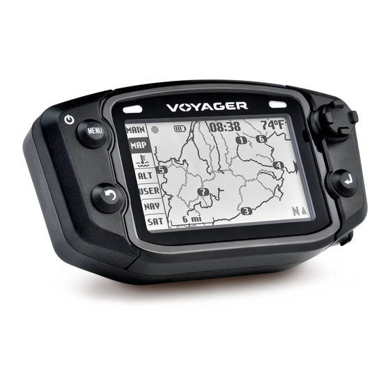
Front of Unit Physical Features Internal GPS Antenna Yellow LED Red LED Joystick (UP, MENU Button LEFT, RIGHT, DOWN) BACK Button ENTER Button MicroSD Card Precision Wheel Sensor Engine Temperature Sensor Ignition Sensor Vehicle Power Ambient Temperature Sensor Trail Tech Voyager... -
Page 11: Internal Battery
Antenna Holes Connector External Antenna: Voyager can run from the An external GPS antenna accessory will get better reception if internal battery, but it is the mounting location interferes with the reception of the internal much better to connect to antenna. - Page 12 Physical Features » Bar Mount Bar Mounting: The included bar clamps fit 7/8” through 1-1/8” handlebars. Place the nuts and bolts as shown. Adjust angle as required. Trail Tech Voyager...
- Page 13 The template on this page is actual size. Use it to drill mounting holes, or other custom mount options. Use the included M5 bolts to mount to any flat surface. If other than provided screws are used, make sure they are not too long for mounting holes or they will damage internal components of Voyager. Trail Tech Voyager...
- Page 14 MicroSD Card Tracks saved on your computer can be placed on the MicroSD memory card, then imported onto Voyager for viewing and route following. This is a great way to share tracks with your friends, or for pre-planning your own trips.
- Page 15 Connect the power cable directly to the vehicle’s See model-specific instructions for mounting 12 volt battery. Alternately tap into the electrical procedure. system (preferably not interrupted by the key Cylinder Head Sensor: switch.) Voyager is For air-cooled machines. polarity independent. Spark Plug Temperature Sensor Power Wire...
- Page 16 If the sensors aren’t installed, you need to enable logging regardless of connected sensors. Voyager can stay on for twice as long if you Set > GPS Settings > Log Option: ALWAYS disable the backlight. In typical use, you can expect 9-14 hours of use with no backlight, or 3.
- Page 17 2. A speed sensor, on the non-spinning part of the wheel. The magnet spins around tripping the sensor switch ATV Speed each time--giving Voyager speed, distance and time Sensor data to compare with the GPS data. The magnet is installed on the brake rotor because it spins with the wheel.
- Page 18 The wheel sensor should be cable-tied to the brake line, then attached to the brake caliper. Magnet Passing Under Sensor Voyager can tell precisely how far and fast it’s traveled by how many times the magnet passes the sensor. Many Motorcycles and ATVs have special installation procedures.
- Page 19 Measure the distance between the marks on the ground in millimeters (multiply inches by 25.4 to convert to mm). Use this number for your wheel size. For accuracy, the rider’s weight should be on the bike when making the measurement. Trail Tech Voyager...
- Page 20 4. Use the numbers to solve for X in the following equation: (actual miles) x (current wheel size) (new wheel size) (current miles) 5 x 2110 4.95 10550 4.95 X = 2131 5. Enter the number you calculate from the above formula into Voyager. Trail Tech Voyager...
-
Page 21: User Interface
User Interface » Main Tab User Interface Voyager has 7 tabbed screens: Main, Map, Main Tab Screen 2: Engine Temperature, Altitude, User Definable, There are two screens in the Main Tab, hinted by Navigation, and Satellites. Switch screens using the side arrow: . -
Page 22: Map Tab
Waypoints are also shown on the map. If you corner of the Pan Mode Indicator have uploaded routes to Voyager, they will be screen.) displayed in gray so that you can follow along. Press BACK to Pause data logging by pressing MENU twice go back to the and toggling the LOG TRACK option. - Page 23 User Interface » Engine Temperature & Altitude Tabs Engine Temperature Tab: Altitude Tab: Voyager displays a graph of the engine The Altitude Tab displays a graph similar to temperature’s history for the current trip in the engine temperature, but shows height above engine temperature tab.
-
Page 24: User Tab
• Avg GPS Speed (2) Data Blocks: • Bearing Display 1-6 data blocks. if you turn • Compass Direction off some blocks, Voyager will center • Input Voltage the remaining blocks on the screen for • Internal Battery Voltage better visibility. - Page 25 Set a destination waypoint at base camp before Latitude / Longitude: leaving, and the navigation compass always Press RIGHT from the satellite screen to view points back in case you get lost.. your current latitude and longitude positions. Trail Tech Voyager...
-
Page 26: Quick Menu
Toggle logging OFF/ON. Even if set to ON, frequently used commands, like toggling GPS logging will still pause if Voyager is not moving, logging. The ride menu controls features related does not have a GPS fix, or if the LOG OPTION to your current ride, or saving/loading tracks. - Page 27 Reset Trip Distance(1) is visible both on the Writes all tracks and waypoints to a file on the Main screen and User screen. Voyager has a MicroSD card. By default, it does not export second counter, Trip Distance(2) visible only on routes, but that can be changed in the ride the User screen.
- Page 28 Routes can be erased, renamed, or individually Difference between Tracks and Routes: toggled on/off. A route appears grey on Voyager. It is intended to show where to ride (i.e. un-ridden trails and roads.) A track appears black on Voyager. It shows the current ride (i.e.
- Page 29 Menu » Ride Menu Waypoints: If you select a destination waypoint, Voyager Waypoint will know that you wish to navigate towards display can it. On the Navigation tab the distance to the be toggled, selected waypoint will be shown (DEST DST)
- Page 30 On the reset menu, you can erase the current ride, or reset the Trip DST/stopwatch counters. Resetting ride memory erases all tracks, routes, and waypoints currently in internal memory. Note that Voyager is unable to erase data from the MicroSD Ride Menu > Import/Export card; if you...
- Page 31 3. A maximum of 300 waypoints can be stored. 4. The MicroSD card can also be filled up, depending what size of card you are using. Voyager is unable to erase data from the MicroSD card; if you need to free up space, do so on your PC.
-
Page 32: Settings Menu
Settings Menu: Unit > Speed/DST Units: The settings menu contains the options that Choose between English or Metric. Changes control the behavior of Voyager. units format for SPD, DST, ODO, and ALT. Unit > Temperature Units: Choose between Fahrenheit or Celsius. - Page 33 Power > Backlight > Timeout (BAT): Power > Power-Save > Turn Off: Set the amount of time the backlight stays lit Voyager shuts down after the allotted time to (since the last button press or wheel movement) conserver power. when running off the internal battery.
- Page 34 GPS > Speed/DST: GPS > Map Auto-Zoom: Voyager can gather speed and distance data in Automatically zooms the map as you move so two ways. By default Voyager uses GPS data that the entire map fits on the screen.
- Page 35 Fast, normal or slow. Fast creates more detailed files, while slow creates smaller file sizes (but If set to “always,” then Voyager will use GPS lower fidelity data.) movement to determine when to stop logging. Because GPS isn’t aware of your vehicle, it has...
- Page 36 User > Signal Bars: display. If turned on, satellite signal strength bars will appear on the main tab screen. User > Personal Information: You are encouraged to input your name, address and phone number for identification purposes. Trail Tech Voyager...
- Page 37 Yellow LED on: 90ºC (190ºF) www.trailtech.net for the latest releases. After Red LED on: 100ºC (210ºF) downloading from Trail Tech, copy the file to the MicroSD card, then select it with this function. Yellow LED flash: 110ºC (230ºF) Red LED flash: 120ºC (250ºF)
- Page 38 GPX Editor The GPX Editor software can be found on the Opening the GPX Editor: CD included in your Voyager kit, or online at Copy the GPX Editor folder from the CD to www.trailtech.net. your desktop or other folder, then double-click GPX_Editor.exe to start the program.
- Page 39 The trails are black because they are routes. They will be Imported Sample File imported into Voyager as grey lines, ready to be ridden and overlaid with a bold track. The roads are tracks, and will be imported in Voyager as bold lines, so you can tell the difference between a road and a trail.
- Page 40 Cut\Split Track Delete On Selected Selected Hand Tool, Pointer Tool, Pans Select Tracks Tabs switch between line-art preview and Google Maps/Satellite/Earth view. Google Maps Tab - Earth view. Hold down the center mouse button to modify perspective. Trail Tech Voyager...
- Page 41 (so it loads faster in click once on the map for each data point (many Voyager.) Select the track with the select tool, data points make up a track segment.) then press the Filter button in the toolbar.
- Page 42 Voyager. 5. Click the Export button. The file will export in .OSM format, which needs to be converted to .GPX for Voyager. Use GPSBabel for the conversion. Trail Tech Voyager...
- Page 43 Use the File Name button to select the files, then click apply. www.GPSbabel.com Before uploading an Openstreetmaps file to Voyager, open it in the GPX editor and delete all of the waypoints (there will be a large number of waypoints that are not necessary.) File Name OpenStreetMap data files...
-
Page 44: Google Earth
Use your mouse to spin the planet, or shift+mouse to change the 3D view angle. You can view tracks exported from Voyager, or downloaded from OHVtrails.net or Openstreetmaps.com. You can also draw tracks that can Google Earth at start be imported into Voyager. - Page 45 Google Earth can import GPX files directly from button in the toolbar. A dialog box Voyager. Select Export on Voyager to save the appears (ignore it for now.) Using your file to the MicroSD card, then on your PC, drag- mouse cursor, click along the path right on top and-drop the GPX file onto Google Earth.
- Page 46 OHVtrails.net OHVtrails.net Download your adventure at www.OHVtrails.net. Download trails and load them directly into Voyager. Entire trail systems are at your fingertips. Hiking trails not allowed; all included trails are either motorcycle, ATV, or snowmobile. Hold down shift and click to tilt the camera into 3D Google Earth mode.
- Page 47 Glossary Glossary Ride Trip Distance A “ride” is the collection of information Voyager Trip distance is a measure of how far you have is currently logging and displaying (including the travelled. While it is part of the current ride map, altitude, engine temperature, trip distance, memory, it can be reset independently.
- Page 48 LIMITED WARRANTY Within one year from the date of original purchase, Trail Tech will repair or replace, at its option, any Trail Tech powersport computer which is deemed defective in workmanship or materials. Please contact Trail Tech or the dealer where the item was purchased for assistance.
Need help?
Do you have a question about the Voyager and is the answer not in the manual?
Questions and answers