Table of Contents
Advertisement
Quick Links
Advertisement
Table of Contents

Related Manuals for Garmin DĒZL OTR700


Summary of Contents for Garmin DĒZL OTR700
- Page 1 DĒZL OTR700 / LGV700 ™ Owner’s Manual...
- Page 2 © 2020 Garmin Ltd. or its subsidiaries All rights reserved. Under the copyright laws, this manual may not be copied, in whole or in part, without the written consent of Garmin. Garmin reserves the right to change or improve its products and to make changes in the content of this manual without obligation to notify any person or organization of such changes or improvements. Go to www.garmin.com...
-
Page 3: Table Of Contents
Table of Contents Finding a Location Using Coordinates........12 Parking..........12 Getting Started.........1 Finding Truck Parking....... 12 dēzl OTR700 / LGV700 Device Finding Truck Parking in Europe..12 Overview..........1 Finding Parking Near Your Current Mounting and Powering the dēzl Device Location.......... - Page 4 Adjusting the Daily Driving Limit..33 Viewing Upcoming Traffic....25 Garmin eLog.......... 33 Viewing Traffic on the Map....25 Setting Up Garmin eLog Features On Searching for Traffic Incidents..25 Your dēzl Device....... 33 Customizing the Map......25 Viewing Garmin eLog Information on Your dēzl Device.......
- Page 5 Charging the Device......45 Viewing Weather Near a Different City............. 38 Device Maintenance....... 45 Viewing the Weather Radar....38 Garmin Support Center......45 Viewing Weather Alerts....38 Map and Software Updates....45 Checking Road Conditions....39 Connecting to a Wi‑Fi Network..46 Trip Planner...........
- Page 6 My device does not connect to my phone............. 50 Appendix........50 Installing a Memory Card for Maps and Data............50 Data Management........ 50 About Memory Cards......50 Connecting the Device to Your Computer........... 50 Transferring Data From Your Computer........... 51 Disconnecting the USB Cable..51 Viewing GPS Signal Status....51 Purchasing Additional Maps....
-
Page 7: Getting Started
Getting Started WARNING See the Important Safety and Product Information guide in the product box for product warnings and other important information. • Update the maps and software on your device (Map and Software Updates, page 45). • Mount the device in your vehicle and connect it to power (Mounting and Powering the dēzl Device in Your Vehicle, page •... -
Page 8: Mounting And Powering The Dēzl Device In Your Vehicle
Mounting and Powering the dēzl Device in Your Vehicle WARNING This product contains a lithium-ion battery. To prevent the possibility of personal injury or product damage caused by battery exposure to extreme heat, store the device out of direct sunlight. Before you use your device on battery power, you should charge it. -
Page 9: Acquiring Gps Signals
Garmin eLog ™ status. Select to view the current ELD information. When the icon is blue, the device is connected to the Garmin eLog app. Current time. Select to set the time (Setting the Time, page 44). Battery charge level. -
Page 10: Adjusting The Volume
Adjusting the Volume 1 Select Volume. 2 Select an option: • Use the slider bar to adjust the volume. • Select to mute the device. • Select a check box to enable or disable additional sound options. Using the Audio Mixer You can use the audio mixer to set the volume levels for different audio types, such as navigation prompts or phone calls. -
Page 11: Switching The Vehicle Profile
Switching the Vehicle Profile Each time you turn on your device, it prompts you to select a vehicle profile. You can manually switch another vehicle profile at any time. 1 From the status bar, select the vehicle profile icon, such as 2 Select a vehicle profile. -
Page 12: Driver Awareness Features And Alerts
CAUTION The driver alerts and speed limit features are for information only and do not replace your responsibility to abide by all posted speed limit signs and to use safe driving judgment at all times. Garmin is not responsible ®... -
Page 13: Red Light And Speed Cameras
Red Light and Speed Cameras NOTICE Garmin is not responsible for the accuracy of or the consequences of using a red light or speed camera database. NOTE: This feature is not available for all regions or product models. Information about red light and speed camera locations is available in some areas for some product models. -
Page 14: Finding An Address
Finding an Address NOTE: The order of the steps may change depending on the map data loaded on your device. 1 Select Where To?. 2 If necessary, select to search near a different city or area. 3 Select Address. 4 Follow the on-screen instructions to enter address information. 5 Select the address. -
Page 15: Location Search Results On The Map
Location Search Results on the Map You can view the results of a location search on the map instead of in a list. From the location search results, select . The nearest location appears at the center of the map, and basic information about the selected location appears at the bottom of the map. -
Page 16: Points Of Interest
Foursquare logo in your location search results. You can connect to your Foursquare account using the Garmin Drive app on your compatible smartphone. This allows you to view Foursquare location details, check in to a location, and search for points of interest in the online Foursquare database. -
Page 17: Tripadvisor
Connecting to Your Foursquare Account Before you can use this feature, your device must be connected to a supported phone running the Garmin Drive (Live Services, Traffic, and Smartphone Features, page 26). 1 On your smartphone, open the Garmin Drive app. -
Page 18: Navigating To Points Of Interest Within A Venue
Navigating to Points of Interest Within a Venue NOTE: This feature may not be available in all areas or for all product models. You can create a route to a point of interest (POI) within a larger venue, such as a store in a shopping mall or a specific terminal in an airport. -
Page 19: Finding Parking Near Your Current Location
Finding Parking Near Your Current Location 1 Select Where To? > Parking. 2 Select Filter Parking, and select one or more categories to filter parking by availability, type, price, or payment methods (optional). NOTE: Detailed parking data is not available in all areas or for all parking locations. 3 Select a parking location. -
Page 20: Finding Emergency Services And Fuel
Finding Emergency Services and Fuel You can use the Where Am I? page to find the nearest hospitals, police stations, and fuel stations. 1 From the map, select the vehicle. 2 Select Hospitals, Police Stations, Fuel, or Roadside Assist.. NOTE: Some service categories are not available in all areas. NOTE: When a truck vehicle profile is active, an option for truck stops appears instead of fuel. -
Page 21: Assigning Categories To A Saved Location
Assigning Categories to a Saved Location You can add custom categories to organize your saved locations. NOTE: Categories appear in the saved locations menu after you have saved at least 12 locations. 1 Select Where To? > Saved. 2 Select a location. 3 Select 4 Select >... -
Page 22: Starting A Route By Using The Map
Starting a Route by Using the Map You can start route by selecting a location from the map. 1 Select View Map. 2 Drag and zoom the map to display the area to search. 3 If necessary, select to filter the displayed points of interest by category. Location markers ( or a blue dot) appear on the map. -
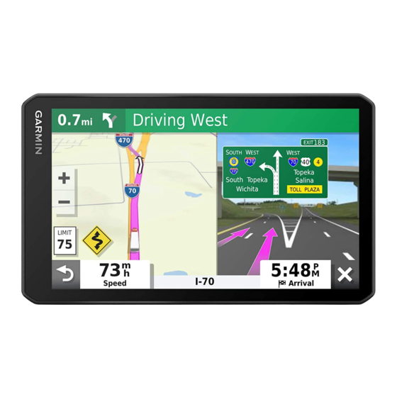
Page 23: Your Route On The Map
Your Route on the Map As you travel, the device guides you to your destination using voice prompts and information on the map. Instructions for your next turn or exit, or other actions appear across the top of the map. Next action in the route. -
Page 24: Viewing Turns And Directions
Viewing Turns and Directions While navigating a route, you can view upcoming turns, lane changes, or other directions for your route. 1 From the map, select an option: • To view upcoming turns and directions as you navigate, select > Turns. The map tool displays the next several turns or directions beside the map. -
Page 25: Parking Near Your Destination
Parking Near Your Destination Your device can help you find a parking spot near your destination. When you approach some destinations, the device automatically suggests parking areas. NOTE: This feature should be used only when you are using the car vehicle profile. While using a truck vehicle profile, you can search for truck parking near your destination (Finding Truck Parking, page 12). -
Page 26: Taking A Detour
Taking a Detour You can take a detour for a specified distance along your route or detour around specific roads. This is useful if you encounter construction zones, closed roads, or poor road conditions. 1 From the map, select > Edit Route. 2 Select an option: •... -
Page 27: Avoiding Toll Stickers
Avoiding Toll Stickers If the map data on your device contains detailed toll sticker information, you can avoid or allow roads that require toll stickers for each country. NOTE: This feature is not available in all areas. 1 Select Settings > Navigation > Tolls and Fees > Toll Stickers. 2 Select a country. -
Page 28: Using The Map
Disabling a Custom Avoidance You can disable a custom avoidance without deleting it. 1 Select Settings > Navigation > Custom Avoidances. 2 Select an avoidance. 3 Select > Disable. Deleting Custom Avoidances 1 Select Settings > Navigation > Custom Avoidances > 2 Select an option: •... -
Page 29: Map Tools
Report Safety Camera: Allows you to report a speed or red light camera. This tool is available only when you have speed or red light camera data on your device and you have an active connection to the Garmin Drive (Live Services, Traffic, and Smartphone Features, page 26). -
Page 30: Customizing The Up Ahead Categories
Customizing the Up Ahead Categories You can change the location categories that appear in the Up Ahead tool. 1 From the map, select > Up Ahead. 2 Select a category. 3 Select 4 Select an option: • To move a category up or down in the list, select and drag the arrow next to the category name. •... -
Page 31: Viewing The Trip Information Page
Viewing the Trip Information Page The trip information page displays your speed and provides statistics about your trip. From the map, select Speed. Resetting Trip Information 1 From the map, select Speed. 2 Select > Reset Field(s). 3 Select an option: •... -
Page 32: Changing The Map Perspective
(Checking in with Foursquare, page 11). Pairing with Your Smartphone You can pair your dēzl device with your smartphone and the Garmin Drive app to enable additional features and access live information (Live Services, Traffic, and Smartphone Features, page 26) . -
Page 33: Disabling Bluetooth Features (Iphone®)
Garmin Drive features and services Smart Notifications While your device is connected to the Garmin Drive app, you can view notifications from your smartphone on your dēzl device, such as text messages, incoming calls, and calendar appointments. NOTE: You may need to wait a few minutes to receive notifications on your navigation device after it connects to the Garmin Drive app. -
Page 34: Receiving Notifications
Do not read or reply to notifications while driving. If you do so, you could become distracted by the display, which could lead to an accident causing serious personal injury or death. Before you can use this feature, your device must be connected to a supported phone running the Garmin Drive (Live Services, Traffic, and Smartphone Features, page 26). -
Page 35: Viewing The List Of Notifications
Going to an Address or Location Using the Garmin Drive App You can use the Garmin Drive app to search for an address, business, or point of interest, and send it to your dēzl device for navigation. 1 From the Garmin Drive app, select Where To?. -
Page 36: Receiving A Call
Calling a Location 1 Select Apps > Phone > Browse Categories. 2 Select a point of interest. 3 Select > Call. Placing a Call Using Voice Dial 1 Select Apps > Phone > Voice Dial. 2 Listen for the voice prompt. 3 Say Call, and say the contact name, phone number, or location you want to call. -
Page 37: Deleting A Paired Phone
Data Using Your Smartphone, page 31). Traffic data is not available in all areas. For information about traffic coverage areas, go to garmin.com/traffic. Receiving Traffic Data Using Your Smartphone Your device can receive subscription-free traffic data while connected to a smartphone running the Garmin Drive app. -
Page 38: Enabling Traffic
Carrier Safety Administration (FMCSA) regulations. Drivers should comply with all applicable federal and state hours-of-service requirements. When integrated with a Garmin eLog compliant Electronic Logging Device (ELD), this device enables a motor carrier to comply with hours of service logging and break requirements. For more information, or to purchase a Garmin eLog device, go to garmin.com/elog. -
Page 39: Starting The Break Timer
Setting Up Your Garmin eLog Device You must set up and pair your Garmin eLog adapter with the Garmin eLog app in order to use the device. 1 From the app store on your mobile device, install and open the Garmin eLog app. -
Page 40: Viewing Garmin Elog Information On Your Dēzl Device
(Setting Up Garmin eLog Features On Your dēzl Device, page 33). As you drive your vehicle, the device displays your duty status and total drive hours in the Garmin eLog map tool. Select a field to view a summary of remaining drive hours. -
Page 41: Editing Fuel Data
Editing Fuel Data 1 Select Apps > IFTA > Fuel Journals. 2 If necessary, select a vehicle profile. 3 If necessary, select a quarter. 4 Select a fuel record. 5 Select an option: • Select a field to edit the information. •... -
Page 42: Logging Service History
Logging Service History You can log the date and odometer reading when service or maintenance is performed on your vehicle. The device provides several service categories, and you can add custom categories (Adding Service Categories, page 36). 1 Select Apps > Service History. 2 Select a service category. -
Page 43: Prepass
The PrePass app enables drivers to verify the safety, credentials, and weight of a commercial vehicle with upcoming weigh stations. You can pair your dēzl device with the Garmin Drive app and the PrePass app to receive upcoming weigh station notifications on your dēzl device. -
Page 44: Changing Device Settings Using Your Voice
• To add a favorite city, select Add City, and enter a city name. Viewing the Weather Radar Before you can use this feature, your device must be connected to a supported phone running the Garmin Drive (Live Services, Traffic, and Smartphone Features, page 26). -
Page 45: Checking Road Conditions
Checking Road Conditions Before you can use this feature, your device must be connected to a supported phone running the Garmin Drive (Live Services, Traffic, and Smartphone Features, page 26). You can view weather-related road conditions for the roads in your area, on your route, or in another city. -
Page 46: Changing Routing Options For A Trip
3 Select Save to save your route as a trip, which you can navigate again later (optional). photoLive Traffic Cameras Before you can use this feature, your device must be connected to the Garmin Drive app (Live Services, Traffic, and Smartphone Features, page 26). -
Page 47: Viewing Photolive Traffic Cameras On The Map
Sets which installed maps the device uses. Enabling Maps You can enable map products installed on your device. TIP: To purchase additional map products, go to http://buy.garmin.com. 1 Select Settings > Map & Vehicle > myMaps. 2 Select a map. -
Page 48: Navigation Settings
Navigation Settings Select Settings > Navigation. Calculation Mode: Sets the route calculation method. Avoidances: Sets road features to avoid on a route. Custom Avoidances: Allows you to avoid specific roads or areas. Toll Roads: Sets preferences for avoiding toll roads. Tolls and Fees: Sets preferences for avoiding toll roads and toll stickers. -
Page 49: Driver Assistance Settings
Alerts: Sets the type of proximity points for which alerts are played. Backup Camera Settings The backup camera settings allow you to manage paired Garmin backup cameras and camera settings. This menu appears on your navigation device only when the device is connected to a wireless camera receiver cable. -
Page 50: Units And Time Settings
Units and Time Settings To open the Units and Time settings page, from the main menu, select Settings > Units & Time. Current Time: Sets the device time. Time Format: Allows you to select a 12-hour, 24-hour, or UTC display time. Units: Sets the unit of measure used for distances. -
Page 51: Device Information
• Connect the device to an optional power adapter accessory, such as a wall power adapter. You can purchase an approved Garmin AC-DC adapter suitable for home or office use from a Garmin dealer or www.garmin.com. The device may charge slowly when connected to a third-party adapter. -
Page 52: Connecting To A Wi-Fi Network
TIP: If a map update is interrupted or canceled before it completes, your device may be missing map data. To repair missing map data, you must update the maps again using either Wi‑Fi or Garmin Express. Device Maintenance... -
Page 53: Updating Maps And Software With Garmin Express
Updating Maps and Software with Garmin Express You can use the Garmin Express application to download and install the latest map and software updates for your device. 1 If you do not have the Garmin Express application installed on your computer, go to garmin.com/express... -
Page 54: Device Care
1 On your computer, go to garmin.com/express. 2 Select an option: • To view the system requirements and verify the Garmin Express application is compatible with your computer, select System Requirements. • To install on a Windows computer, select Download for Windows. -
Page 55: Removing The Mount From The Suction Cup
Removing the Mount from the Suction Cup 1 Turn the device mount to the right or left. 2 Apply pressure until the socket on the mount releases the ball on the suction cup. Removing the Suction Cup from the Windshield 1 Flip the lever on the suction cup toward you. -
Page 56: My Battery Does Not Stay Charged For Very Long
Garmin mapping software. The device supports microSD memory cards from 4 to 32 GB. Memory cards must use the FAT32 file system format. Memory cards greater than 32 GB must be formatted using the device. - Page 57 3 Select a file. 4 Select Edit > Copy. 5 Browse to a folder on the device. NOTE: For a removable drive or volume, you should not place files in the Garmin folder. 6 Select Edit > Paste. Disconnecting the USB Cable If your device is connected to your computer as a removable drive or volume, you must safely disconnect your device from your computer to avoid data loss.
- Page 58 49 disabling 22 fuel, stations 14 myTrends, routes 20 road 21 fuel data 34, 35 road features 21 fuse, changing 49 tolls 20, 21 navigation 12, 17, 18, 37 settings 42 Garmin Connect 26 next turn 17 backup camera 43 Garmin Express 48 notifications 26–29, 34 battery updating software 47 charging 2, 45, 49 geocaching 12 maximizing 50 on-screen buttons 3...
- Page 59 starting 8, 9, 15, 16 stopping 20 vehicle power cable 2 suggested 20 vehicle profile, truck 4, 5 viewing on the map 17, 18 voice command 37 activating 37 tips 37 satellite signals voice dial 30 acquiring 3 volume, adjusting 4, 38 viewing 51 saved locations 40 categories 15 weather 38 deleting 15 radar 38 editing 14 road conditions 39 saving, current location 14 Where Am...
- Page 60 May 2021 GUID-430519C4-E07D-41FA-A21D-E1F2E797924E v2...
Need help?
Do you have a question about the DĒZL OTR700 and is the answer not in the manual?
Questions and answers