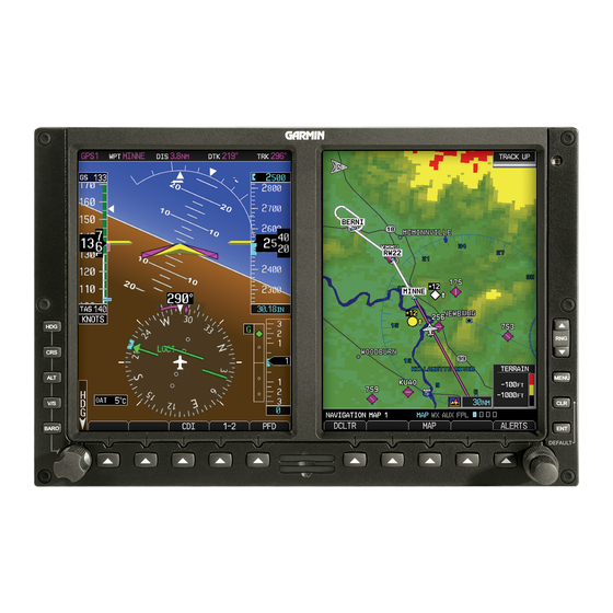
Sign In
Upload
Manuals
Brands
Garmin Manuals
Avionics Display
G500
Garmin G500 Manuals
Manuals and User Guides for Garmin G500. We have
12
Garmin G500 manuals available for free PDF download: Pilot's Manual, Instructions Manual, Maintenance Manual, Reference Manual, Cockpit Reference Manual, Manual, Quick Reference
Garmin G500 Pilot's Manual (410 pages)
Brand:
Garmin
| Category:
Avionics Display
| Size: 51.34 MB
Table of Contents
Table of Contents
13
1 System Overview
23
System Description
23
Standard System Line Replaceable Units
25
Gdu 620
26
Air Data Computer
27
Attitude Heading Reference System
27
Gmu 44
31
Garmin Navigator Interface
31
Optional Line Replaceable Units
32
Gdl 88
32
Gtx 345
32
Weather Radar
32
Stormscope
32
Gsr 56
33
Gdl 69/69A
33
GAD 43/43E
33
Gtx 330/330D/335
34
System Power up
35
International Geomagnetic Reference Field
37
System Operation
38
Pilot Controls
38
PFD Knob
38
PFD Bezel Keys
39
MFD Knobs
41
MFD Bezel Keys
41
Using the Soft Key Controls
42
Using the
42
System Settings
43
Display Backlighting
45
2 Primary Flight Display
47
PFD Soft Keys
48
Airspeed Indicator
51
Markings
53
Reference Speeds
54
Attitude Indicator
55
Extreme Attitude
57
Altimeter
59
Setting the Altitude Bug and Alerter
59
Altitude Alerting
60
Changing Barometric Setting
61
Minimum Descent Altitude/Decision Height Alerting
62
Vertical Speed Indicator
64
Horizontal Situational Indicator
65
Setting the Heading Bug
66
Turn Rate Indicator
67
Course Deviation Indicator
68
Changing CDI Sources
68
Changing CDI Course
70
Vertical Deviation Indicator
70
Auto-Slewing
71
Supplemental Flight Data
74
Bearing Pointers
74
Temperature Display
75
Wind Vectors
76
DME Indication
76
Marker Beacon Annunciations
77
Miscompare Annunciations
77
Radar Altimeter
79
2.10 Fast/Slow Indication
81
2.11 PFD Display Units
81
3 Multi-Function Display
83
Navigation Map
84
Default Navigation Map Page
85
Map Overlay Icons
85
Selecting
86
Changing the Navigation Map Range
86
Decluttering Map
86
Panning
88
Selecting Items on the Map
89
Measuring Distances
89
Customizing Navigation Map
90
Map Setup
90
Map Feature Options
92
Weather Feature Options (Optional)
99
Traffic Feature Options (Optional)
102
Aviation Feature Options
103
Split Screen (Optional)
108
Aux Mode Pages
109
System Settings
109
Display Brightness
110
Airspeed Reference Marks
111
PFD Options - Wind Vector
112
PFD Options - Nav Status
112
Temperature Reference
113
Synchronization
114
Date and Time
116
MFD Display Units
117
System Display Units
118
Data Link
119
Sirius XM Information (Optional)
120
Sirius XM Entertainment Radio (Optional)
121
System Status
122
Database Sync Operation
123
Resolving Database Conflicts
127
Chart Streaming
128
ADS-B/FIS-B Status (Optional)
129
External Video (Optional)
130
Select Video Source
130
Zoom
131
Panning
131
Setup
131
Restore Defaults
133
Full Screen
134
Position Reporting (Optional)
135
Status
135
Report Type
135
Iridium Phone Operation (Optional)
138
Status
138
Managing the Phone Book
140
Phone Volume
143
Making a Phone Call
144
Answering a Phone Call
145
Flight Plan
146
Active Flight Plan Page
146
Active Flight Plan Detail
147
Active Flight Plan Options
147
Setting the Altitude Minimums Alerter
148
Waypoint Information Page
149
Selecting a Waypoint
150
Waypoint/Runway/Frequency Information Detail
152
Airport Directory
155
Waypoint Weather Information (Optional)
156
Charts Page (Optional)
156
Advertisement
Garmin G500 Pilot's Manual (440 pages)
Brand:
Garmin
| Category:
Avionics Display
| Size: 25.4 MB
Table of Contents
Table of Contents
3
System Description
29
System Overview
30
Display Layout
31
Display Configurations
32
System Functions
35
Pilot Interface
36
Unit Power
36
Power off Options
36
SD Card Slot
37
Touchscreen
38
Keys
39
Menus
40
Lists
41
Tabs
41
Keypads
42
Control Knobs
43
Knob Function Indicators
44
Screen Captures
45
Color Conventions
46
Databases
47
Database Effective Cycles
48
Active and Standby Databases
49
Manual Updates
49
Database Update Page
49
Automatic Updates
51
Database Concierge
52
Database SYNC
54
Chart Streaming
55
Connectivity
56
Flight Stream 510 Setup
56
Bluetooth Setup
57
Managing Paired Devices
57
Wi-Fi Setup
58
Connecting to Wi-Fi
58
Viewing Wi-Fi Information
59
Pilot Settings
60
Display Brightness Control
60
Automatic Brightness Control
60
Manual Brightness Control
60
System Status Page
61
Click Volume
61
Clock
61
Weather Display Shortcut
61
Unit Selections
62
Crew Profiles
63
Crew Profile Settings
63
Crew Profile Management
65
System & Function Advisories
67
Warnings & Cautions
67
Alerts Types
67
System Messages
67
Alert Annunciations
68
Pop-Up Alerts
69
Aural Alerts
71
Advisories
72
Audio Advisories
73
Battery Advisories
73
Database Advisories
74
Emergency Descent Mode Advisories
75
Engine System Advisories
76
Terrain Advisories
77
Traffic System Advisories
78
Satellite Service Advisories
79
PFD Advisories
79
System Hardware Advisories
82
Weather Service Advisories
83
LRU Failure Annunciations
84
PFD Failure Annunciations
84
EIS Failure Annunciations
85
Logs
86
Flight Data Logging
86
Exporting to SD Card
88
Streaming to Garmin Pilot
90
Exceedance Logging
91
Exceedance Alerts
93
Exceedance Details
94
Exporting to SD Card
94
Compatible Equipment
95
Line Replaceable Units
95
LRU Status
96
Integrated Standby Instrument - Piston Aircraft
96
Standby Instruments
97
PFD Controller
98
Backup Battery
99
Adc & Ahrs
99
PFD Adapter
100
Autopilot
100
Weather & Music
103
Engine Monitoring
106
Magnetometer
107
Navigation/Fms
107
Temperature Probe
107
Radar Altimeter
108
Traffic
109
2 Primary Flight Display
111
PFD Setup
113
Synchronization Options
115
Reference Bugs and Controls
116
Flight Instruments
119
Attitude Indicator
121
Attitude Sync, Rotorcraft Only
123
Extreme Attitude Indications
124
VNAV Guidance Indications
126
Airspeed Indicator
127
Reference Markings
129
Reference Speeds
130
Barometric Altimeter
131
Fast/Slow Indicator
131
Adjusting Barometric Pressure
134
Adjusting Selected Altitude
135
Temperature Compensation Minimums
136
MDA/DH Alerting
137
Vsi
138
Selected Vertical Speed
140
Horizontal Situation Indicator
141
Setting the Heading Bug
143
HSI Annunciations
144
CDI
147
Course Pointer Types
148
Cross Track Error Indication
148
CDI Source Selection
149
Selected Course with GPS
150
Selected Course with VOR/LOC
150
Automatic Source Selection
151
Auto-Slewing
152
Ldi
153
Reverse Sensing Correction
153
VDI
154
VNAV Deviation Indications
155
CDI/VDI Preview
156
Bearing Pointers
159
Supplemental Flight Data
159
GPS NAV Status Field
161
Relative Wind Data
162
Temp/Dalt Display
163
DME Display
164
Marker Beacon Symbols
165
Radar Altitude
165
Clock/Timer
166
RA Test
166
Garmin G500 Pilot's Manual (358 pages)
Brand:
Garmin
| Category:
GPS
| Size: 9.71 MB
Table of Contents
Aviation Limited Warranty
3
Aopa Airport Directory
8
Table of Contents
9
1 System Overview
17
System Description
17
Line Replaceable Units (LRU)
18
Gdu 620
19
Gdc 74A
20
Grs 77
20
Gmu 44
21
GTX 330/330D (Optional)
21
Gtp 59
21
Gsr 56
21
GDL 69/69A (Optional)
22
GAD 43(E) (Optional)
22
Weather Radar
23
Garmin Navigator Interface
23
Attitude Heading Reference System (AHRS)
23
Secure Digital Cards
26
System Power up
27
International Geomagnetic Reference Field
29
System Operation
30
Pilot Controls
30
PFD Knob
30
PFD Bezel Keys
31
MFD Knobs
33
MFD Bezel Keys
33
Using the Soft Key Controls
34
Using the
35
System Settings
36
System Settings Values
37
Display Backlighting
39
2 Primary Flight Display (PFD)
41
PFD Soft Keys
42
Airspeed Indicator
45
Markings
47
Reference Speeds
48
Attitude Indicator
49
Extreme Attitude
51
Altimeter
53
Setting the Altitude Bug and Alerter
53
Altitude Alerting
54
Changing Barometric Setting
55
Minimum Descent Altitude/Decision Height Alerting
55
Vertical Speed (V/S) Indicator
58
Horizontal Situational Indicator
59
Setting the Heading Bug
60
Turn Rate Indicator
61
Course Deviation Indicator
61
Changing CDI Sources
62
Changing CDI Course
63
Vertical Deviation Indicator (VDI)
64
Auto-Slewing
65
Supplemental Flight Data
67
Bearing Pointers
67
Temperature Display
69
Wind Vectors
69
DME Indication
69
Marker Beacon Annunciations
70
Miscompare Annunciations
70
Radar Altimeter
72
2.10 Fast/Slow Indication
73
2.11 PFD Display Units
74
3 Multi-Function Display (MFD)
75
Functional Display Map
76
MFD Soft Key Map
77
Navigation Map
78
Default Navigation Map Page
79
Editing Information
79
Selecting
79
Changing the Navigation Map Range
79
Decluttering Map Pages
80
Panning
82
Selecting Items on the Map
83
Measuring Distances
84
Customizing Navigation Map
85
Map Setup
85
Map Feature Options
87
Auto Zoom
89
Field of View
100
Weather Feature Options (Optional)
101
Traffic Feature Options (Optional)
104
Aviation Feature Options
105
Split Screen (Optional)
116
Aux Mode Pages
117
System Settings
117
Display Brightness
118
Airspeed Reference Marks
119
PFD Options - Wind Vector
120
PFD Options - Nav Status
121
Synchronization (Dual Installations Only)
122
Date and Time
124
MFD Display Units
125
System Display Units
126
Sirius XM Satellite Radio XM Information (Optional)
127
Sirius XM Satellite Radio XM Entertainment Radio (Optional)
128
System Status
129
External Video (Optional)
130
Select Video Source
130
Zoom
131
Panning
131
Setup
131
Brightness Adjustment
132
Contrast Adjustment
132
Restore Defaults
133
Position Reporting (Optional)
134
Status
134
Report Type
134
Iridium Phone Operation (Optional)
137
Status
137
Managing the Phone Book
139
Phone Volume
142
Making a Phone Call
143
Answering a Phone Call
144
Flight Plan
145
Active Flight Plan Page
145
Active Flight Plan Detail
146
Active Flight Plan Options
146
Setting the Altitude Minimums Alerter
147
Waypoint Information Page
148
Selecting a Waypoint
149
Waypoint Information Detail
150
Airport Directory
153
Waypoint Weather Information (Optional)
154
Charts Page (Optional)
155
Viewing Charts
156
Selecting a New Chart by Airport
157
Selecting a New Chart by FPL, NRST, or RECENT
158
Change Day/Night View
158
Advertisement
Garmin G500 Pilot's Manual (290 pages)
Avionics Display System
Brand:
Garmin
| Category:
Avionics Display
| Size: 21.72 MB
Table of Contents
Limited Warranty
3
Table of Contents
9
1 System Overview
17
System Description
17
Line Replaceable Units (LRU)
18
Gdu 620
19
Gdc 74A
19
Grs 77
20
Gmu 44
20
GTX 330/330D (Optional)
21
Gtp 59
21
GDL 69/69A (Optional)
22
GAD 43 (Optional)
22
GWX 68 Weather Radar
23
Garmin Navigator Interface
23
Attitude Heading Reference System (AHRS)
23
Secure Data Cards
24
Pilot Controls
25
PFD Knob
25
PFD Bezel Keys
26
PFD Soft Keys
27
MFD Knobs
29
MFD Bezel Keys
29
MFD Soft Keys
30
System Power up
31
Annunciations and Alerts
31
Autopilot Test
32
International Geomagnetic Reference Field
33
System Operation
33
Using the
33
Navigating Within a Menu
34
Using the Soft Key Controls
34
System Settings
35
Display Backlighting
37
Dual GDU 620 Installations
38
Crossfill Information
38
Crossfill Selection
39
2 Primary Flight Display (PFD)
41
PFD Soft Key Map
42
Airspeed Indicator
42
Markings
43
Reference Speeds
45
Attitude Indicator
45
Extreme Attitude
47
Altimeter
49
Setting the Altitude Bug and Alerter
49
Altitude Alerting
50
Changing Barometric Setting
50
Minimum Descent Altitude/Decision Height Alerting
51
Vertical Speed (V/S) Indicator
53
Horizontal Situational Indicator
54
Setting the Heading Bug
55
Turn Rate Indicator
56
Course Deviation Indicator
56
Changing CDI Sources
57
Changing CDI Course
58
Vertical Deviation Indicator (VDI)
59
Auto-Slewing
60
Supplemental Flight Data
62
Bearing Pointers
62
Temperature Display
64
Wind Vectors
64
3 Multi-Function Display (MFD)
65
Functional Display Map
66
MFD Soft Key Map
67
Navigation Map
68
Default Navigation Map Page
69
Editing Information
69
Selecting
69
Changing the Navigation Map Range
69
Decluttering Map Pages
70
Selecting Items on the Map
73
Measuring Distances
74
Customizing Navigation Map
75
Map Setup
75
Map Feature Options
77
Weather Feature Options (Optional)
91
Traffic Feature Options (Optional)
94
Aviation Feature Options
95
Aux Mode Pages
106
System Settings
106
Display Brightness
107
Airspeed Reference Marks
108
PFD Options - Wind Vector
109
Synchronization (Dual Installations Only)
110
Date and Time
111
MFD Display Units
112
System Display Units
113
XM Information (Optional)
114
XM Entertainment Radio (Optional)
115
System Status
116
Flight Plan
117
Active Flight Plan Page
117
Active Flight Plan Detail
118
Active Flight Plan Options
118
Setting the Altitude Minimums Alerter
119
Waypoint Information Page
120
Selecting a Waypoint
120
Waypoint Information Detail
121
Waypoint Weather Information (Optional)
123
Charts Page (Optional)
125
Viewing Charts
126
Selecting a New Chart by Airport
127
Selecting a New Chart by FPL, NRST, or RECENT
128
Change Day/Night View
128
Garmin G500 Instructions Manual (334 pages)
Integrated Flight Display for Aquila AT01
Brand:
Garmin
| Category:
Avionics Display
| Size: 16.51 MB
Table of Contents
Table of Contents
269
Purpose
270
Scope
270
Document Control
270
Airworthiness Limitations Section
270
Permission to Use Certain Documents
270
Introduction
271
Definitions
271
Instructions for Continued Airworthiness
271
Description of Alteration
272
Control, Operating Information
272
Servicing Information
273
Periodic Maintenance Instructions
274
Troubleshooting Information
276
Removal and Replacement Information
277
Diagrams
277
Special Inspection Requirements
277
Application of Protective Treatments
278
Data Relative to Structural Fasteners
278
Special Tools
278
Additional Instructions
278
Overhaul Period
278
ICA Revision and Distribution
278
Assistance
279
Implementation and Record Keeping
279
System
280
LRU Locations
280
Wire Routing - Single-Engine
281
Wire Routing - Twin-Engine
282
Section 1. General
294
G500/G600 Primary Flight / Multi-Function Display System
294
System Power Sources
295
Navigation Sources
295
Synthetic Vision Technology (Svt)
296
Autopilot Interface
297
Audio Panel
298
Traffic Display
298
Weather Data
298
Video Display
298
Radar Altimeter
298
High Speed Data Bus Interface
299
Single G500/G600 Operational Block Diagram
300
Dual G500/G600 Operational Block Diagram
301
Definitions
302
Section 2. Limitations
303
Cockpit Reference & Pilot's Guide
303
System Software Requirements
303
Moving Map
303
Database Cards
303
Adahrs and Ahrs Operational Area
303
Garmin G500 Maintenance Manual (137 pages)
TXi Part 23 AML STC
Brand:
Garmin
| Category:
GPS
| Size: 15.85 MB
Table of Contents
Table of Contents
10
1 Introduction
15
Publications
16
Revision and Distribution
16
Terminology and Acronyms
16
Table 1-1 Reference Documentation
16
2 System Description
18
System Overview
18
Table 2-1 AML STC Installed Sensors
19
MFD Functionality
19
EIS Functionality
19
Figure 2-1 Entering the Configuration Mode on the GDU
20
Entering Configuration Mode
20
SD Card Location Options
20
Save/Load SD
21
Figure 2-2 GDU 700P MFD, PFD or EIS Display Configuration
22
LRU Description, Control, and Operation
22
Table 2-2 G500/600 Txi LRU Electrical Load
22
Electrical Load Information
22
GDU 700P Display
22
Figure 2-3 GDU 700P Features and Controls
23
Figure 2-4 the GDU 700L EIS Unit
24
GDU 700L Display
24
Figure 2-5 GDU 700L Features and Controls
25
Figure 2-6 the GDU 1060 Functioning as an MFD/PFD and MFD/PFD/EIS
25
GDU 1060 Display
25
Figure 2-7 GDU 1060 Features and Controls
26
GCU 485 Control Unit
26
Figure 2-8 GCU 485 (P/N 011-03582-01 Shown)
27
Figure 2-9 Garmin Backup GPS Antenna
27
Backup GPS Antenna
27
Integrated ADAHRS Unit
27
Figure 2-10 GSU 75() ADAHRS Unit
28
Figure 2-11 GRS 79 AHRS Unit
28
GSU 75() ADAHRS Unit
28
GRS 79 AHRS Unit
28
Figure 2-12 GDC 72 ADC Unit
29
Figure 2-13 GMU 44 Magnetometer
29
GDC 72 ADC Unit
29
GMU 44 Magnetometer
29
Figure 2-14 GTP 59 Outside Air Temperature Probe
30
Figure 2-15 GBB 54 Backup Battery
30
GTP 59 OAT Probe
30
GBB 54 Backup Battery
30
Figure 2-16 GEA 110 Engine Interface
31
GEA 110 Engine Interface
31
Figure 2-17 GAD 43 (Left) and GAD 43E (Right)
32
GAD 43/43E Adapter
32
Figure 2-18 Engine Annunciator
33
Figure 2-19 Carburetor Temperature Probe
33
Figure 2-20 Oil Temperature Probe
33
Figure 2-21 Fuel Flow Sensor FT-60 (Left) and FT-90 (Right)
34
Figure 2-22 Brass Pressure Sensor
34
Figure 2-23 Stainless Steel Pressure Sensor
34
Maintenance Intervals
36
Servicing Information
36
Table 3-1 Periodic Maintenance
36
Electrical Bonding Check
38
Visual Inspection
38
RVSM Periodic Maintenance (Socata TBM 700/850 Only)
39
Table 3-2 Electrical Bonding Requirements
39
Application of Protective Treatments
40
Overhaul Period
40
Special Inspection Requirements
40
Additional Instructions
41
Data Relative to Structural Fasteners
41
4 Troubleshooting
42
General System Troubleshooting
42
Table 4-1 G500/G600 Txi Failures
42
Connector Information
43
Figure 4-1 62 Pin D-Sub Connectors Numbering Scheme for Female/Male Contacts
43
System Maintenance Log
43
Figure 4-2 GDU 700P Connectors
44
Gdu 1060/700
44
Figure 4-3 GCU 485 Connector
48
Gcu 485
48
Gdc 72
49
Figure 4-4 View of J721 Connector Looking at GDC 72
49
Figure 4-5 View of J751 Connector Looking at GSU 75()
51
Gsu 75()
51
Grs 79
53
Figure 4-6 View of J791 Connector Looking at GRS 79
53
Figure 4-7 GAD 43/43E J431/P431 Connector Looking at Unit
55
GAD 43/43E
55
Figure 4-8 GAD 43E J432/P432 Connector Looking at Unit
56
GAD 43E
56
Figure 4-9 GAD 43E J433/P433 Connector Looking at Unit
57
Figure 4-10 GEA 110 Connectors
58
Figure 4-11 GEA 110 J1101/P1101 Connector Looking at Unit
58
Gea 110
58
Figure 4-12 GEA 110 J1102/P1102 Connector Looking at Unit
59
Figure 4-13 GBB 54 J541/P541 Connector
61
Gbb 54
61
Gmu 44
62
Gtp 59
62
Troubleshooting Flow Charts
63
Figure 4-14 GDU Alert Message Troubleshooting
64
Figure 4-15 GDU Config and Battery Alert Message Troubleshooting
65
Figure 4-16 PFD Alert Message Troubleshooting
66
Figure 4-17 AHRS/ADC Alert Message Troubleshooting
67
Figure 4-18 Terrain Alert Message Troubleshooting
68
Figure 4-19 Traffic Alert Message Troubleshooting
69
Figure 4-20 Audio/Weather Alert Message Troubleshooting
70
Figure 4-21 External LRU Failure Message Troubleshooting
71
Figure 4-22 External LRU Service Message Troubleshooting
72
Figure 4-23 GAD Fault Message Troubleshooting
73
Figure 4-24 GAD Fault Message Troubleshooting Continued
74
Figure 4-25 EIS Gauge Troubleshooting
75
Garmin G500 Reference Manual (104 pages)
Avionics Display Systems
Brand:
Garmin
| Category:
Avionics Display
| Size: 3.97 MB
Table of Contents
Aviation Limited Warranty
3
Table of Contents
11
Warnings, Cautions, & Notes
13
Introduction
13
Primary Flight Display (PFD)
14
Airspeed Tape
16
Altitude Tape
18
Barometric Pressure
18
Minimum Descent Altitude/Decision Height Alerting
19
Altitude Bug
21
Fast/Slow Indication
21
Wind Vectors
22
Vertical Speed (V/S)
22
Vertical Deviation Indicator (VDI)
23
Temperature Display
23
DME Indication
24
Clock/Timer
24
Attitude Indicator
24
Horizontal Situation Indicator (HSI): Aircraft Heading
25
Adjusting the Course Pointer
26
HSI Bearing Pointers
26
Marker Beacon Annunciations
28
Miscompare Annunciations
29
Autopilot (AP)
31
GAD 43 Attitude
31
Heading
32
Altitude Capture (Optional Upgrade)
32
Autopilot Navigation
32
Gpss
33
Flight Director Display
34
Vertical Speed Control
34
Autopilot Mode Annunciations
35
Additional Features
36
Synthetic Vision Technology
36
Displaying SVT ™ Terrain
37
Displaying Heading on the Horizon
37
Displaying Airport Signs
37
Multi-Function Display (MFD)
38
Page Navigation - Moving between Pages
39
Changing Settings Within a Page
39
Default Map Page
39
MFD Soft Key Map
40
Map Group
41
Navigation Map 1 and Navigation Map 2 Pages
41
Decluttering (DCLTR) the Map Pages
42
Split Screen Page (Optional)
46
Traffic Map Page (Optional)
47
Terrain/Taws-B Page
53
Terrain Pop-Up Alerts
55
Garmin G500 Reference Manual (90 pages)
Avionics Display System
Brand:
Garmin
| Category:
Avionics Display
| Size: 6.95 MB
Table of Contents
Aviation Limited Warranty
3
Table of Contents
9
Warnings, Cautions, & Notes
11
Introduction
11
Primary Flight Display (PFD)
12
Airspeed Tape
14
Reference Speeds
15
Altitude Tape
16
Barometric Pressure
16
Minimums Bug (Barometric or Radar Altimeter)
17
Altitude Bug
19
Fast/Slow Indication
19
Wind Vectors
20
Vertical Speed (V/S)
20
Vertical Deviation Indicator (VDI)
21
Outside Air Temperature (OAT)
21
DME Indication
21
Attitude Indicator
22
Horizontal Situation Indicator (HSI): Aircraft Heading
23
Adjusting the Course Pointer
24
HSI Bearing Pointers
24
Marker Beacon Annunciations
26
Miscompare Annunciations
26
Autopilot (AP)
28
GAD 43 Attitude
28
Heading
29
Altitude Capture (Optional Upgrade)
29
Autopilot Navigation
29
Gpss
30
Flight Director Display
31
Vertical Speed Control
32
Autopilot Mode Annunciations
32
Additional Features
33
Garmin Synthetic Vision Technology (Optional)
33
Displaying Garmin SVT Terrain
34
Displaying Heading on the Horizon
34
Displaying Airport Signs
34
Multi-Function Display (MFD)
35
Page Navigation - Moving between Pages
36
Changing Settings Within a Page
36
Default Map Page
36
MFD Soft Key Map
37
Map Group
38
Navigation Map 1 and Navigation Map 2 Pages
38
Decluttering (DCLTR) the Map Pages
39
Split Screen Page (Optional)
42
Traffi C Map Page (Optional)
43
Terrain Page
47
Terrain Pop-Up Alerts
49
Garmin G500 Cockpit Reference Manual (76 pages)
Garmin Avionics Display System Cockpit Reference Guide
Brand:
Garmin
| Category:
Avionics Display
| Size: 6 MB
Table of Contents
Limited Warranty
3
Table of Contents
9
Warnings, Cautions, & Notes
11
Introduction
11
Primary Flight Display (PFD)
12
Airspeed Tape
14
Altitude Tape
15
Barometric Pressure
15
Barometric Minimums Bug
16
Altitude Bug
17
Wind Vectors
18
Vertical Speed (V/S)
18
Vertical Deviation Indicator (VDI)
19
Outside Air Temperature (OAT)
19
Attitude Indicator
20
Horizontal Situation Indicator (HSI): Aircraft Heading
21
Adjusting the Course Pointer
22
HSI Bearing Pointers
22
Gps Mode
23
Autopilot (AP)
25
Heading
25
Autopilot Test
25
Altitude Capture (Optional Interface)
26
Autopilot Navigation
26
Autopilot Operation with the GDU 620 Emulating GPSS
27
Additional Features
28
Garmin Synthetic Vision Technology (Optional)
28
Displaying Garmin SVT Terrain
29
Displaying Heading on the Horizon
29
Displaying Airport Signs
29
Multi-Function Display (MFD)
30
Page Navigation - Moving between Pages
31
Changing Settings Within a Page
31
Default Map Page
31
MFD Soft Key Map
32
Map Group
33
Navigation Map 1 and Navigation Map 2 Pages
33
Decluttering (DCLTR) the Map Pages
34
Traffi C Map Page (Optional)
37
Terrain Page
41
Terrain Pop-Up Alerts
43
WX Group
44
WX Data Link Map Pages
44
Customizing the Weather Map
44
Displaying Surface Data and Winds Aloft
46
Weather Radar (Optional)
47
Weather Radar Map Page
47
Airborne Color Weather Radar
48
Adjusting Gain
49
Antenna Stabilization
50
Garmin G500 Manual (40 pages)
PRIMARY FLIGHT AND MULTIFUCTION DISPLAY SYSTEM
Brand:
Garmin
| Category:
Avionics Display
| Size: 0.8 MB
Table of Contents
Table of Contents
7
Section 1. General
9
Garmin G500 Primary Flight / Multi-Function Display System
9
System Power Sources
9
Navigation Sources
10
Synthetic Vision Technology
10
Autopilot Interface
11
Audio Panel
12
Traffic and Weather Systems
12
Video Sources
12
Radar Altimeter
12
High Speed Data Bus Interface
12
Single G500 Operational Block Diagram
13
Dual G500 Operational Block Diagram
14
Definitions
15
Section 2. Limitations
16
Cockpit Reference & Pilot's Guide
16
System Software Requirements
16
Moving Map
16
Database Cards
16
Ahrs Operational Area
17
Magnetic Variation Operational Area
17
Navigation Angle
18
Ahrs Normal Operating Mode
18
Airspeed Limitations and Indicator Markings
18
Aerobatic Maneuvers
18
Electric Standby Attitude Gyro
18
Course Pointer Auto Slewing
19
Synthetic Vision Technology
19
Autopilot Interface
19
Terrain Proximity Function
20
TAWS Annunciations on the PFD [From a Garmin Navigator]
20
Datalinked Weather Display (XM or GFDS Weather)
20
Traffic Display
20
Active Weather Radar
21
Kinds of Operations
22
Kfc 275/325 Altitude Preselect
22
Esi-1000 Electronic Standby Instrument
23
Electronic Flight Bag (Efb) Applications
23
Surface Operations
23
Mfd Video Display
23
Section 3. Emergency Procedures
24
Emergency Procedures
24
Abnormal Procedures
27
Warnings, Cautions, and Advisories
29
Section 4. Normal Procedures
32
Pfd Knob & Pfd Soft Keys
32
Mfd Knobs & Mfd Soft Keys
32
Altitude Synchronization
33
Electric Standby Attitude Gyro
33
Garmin G500 Instructions Manual (14 pages)
Brand:
Garmin
| Category:
Avionics Display
| Size: 0.75 MB
Table of Contents
Table of Contents
2
Purpose
3
Scope
3
Document Control
3
Airworthiness Limitations Section
3
Permission to Use Certain Documents
3
Introduction
4
Definitions
4
Instructions for Continued Airworthiness
4
Description of Alteration
5
Control, Operating Information
5
Servicing Information
6
Periodic Maintenance Instructions
6
Troubleshooting Information
9
Removal and Replacement Information
9
Diagrams
10
Special Inspection Requirements
10
Application of Protective Treatments
10
Data Relative to Structural Fasteners
10
Special Tools
10
Additional Instructions
11
Overhaul Period
11
ICA Revision and Distribution
11
Assistance
11
Implementation and Record Keeping
11
System
12
LRU Locations
12
Wire Routing - Single-Engine
13
Wire Routing - Twin-Engine
14
Garmin G500 Quick Reference (2 pages)
Brand:
Garmin
| Category:
Avionics Display
| Size: 1.43 MB
Advertisement
Related Products
Garmin G5000
Garmin APOLLO GX65
Garmin G950
Garmin GTN 6XX
Garmin GIA 63
Garmin GMA 245
Garmin GMA 1347D-00
Garmin G1000 NAV III
Garmin G3000
Garmin GDC 74A
Garmin Categories
GPS
Watch
Car Navigation system
Avionics Display
Marine GPS System
More Garmin Manuals
Login
Sign In
OR
Sign in with Facebook
Sign in with Google
Upload manual
Upload from disk
Upload from URL