
Related Manuals for Honeywell KMD 550/850


Summary of Contents for Honeywell KMD 550/850
- Page 1 KMD 550/850 Multi-Function Display Flight Information Services (FIS) Pilot’s Guide Addendum For Software Version 01/11 or later 006-18237-0000 Revision 2 November/2002...
- Page 2 All rights reserved. Reproduction of this publication or any portion thereof by any means without the express written permission of Honeywell International Inc. is prohibited. For further information contact the Manager, Technical Publications; Honeywell, One Technology Center, 23500 West 105th Street, Olathe, Kansas 66061.
- Page 3 SUPPLEMENTAL SHEET When studying the FIS Addendum, the following information may be helpful going in. FIS Datalink Weather gives a “situation awareness” of one’s position, or planned position, in relation to the weather. It is a tool that can be used to plan for the circumnavigation of severe weather (strategic planning).
-
Page 4: Table Of Contents
FIS ALERT, NO VALID FIS SUBSCRIPTIONS ....43 NO DATA RECEIVED FROM FIS RECEIVER ....43 Revision 2 November/2002 KMD 550/850 FIS Addendum... - Page 5 FIS DATA ..........48 APPENDIX A, UNDERSTANDING METAR , SPECI , TAF & PIREP . .A-1 APPENDIX B, COMMON WEATHER ABBREVIATIONS ....B-1 Revision 2 November/2002 KMD 550/850 FIS Addendum...
-
Page 6: Introduction
VHF Data Link (VDL) to aircraft within line-of-sight utilizing VDL mode 2 transmitters at a bit rate up to 31.5 kbps. The following diagram illustrates how FIS data is received in the aircraft. Revision 2 Nov/2002 KMD 550/850 FIS Addendum... - Page 7 To receive FIS products, an aircraft must be equipped with a compatible VDL receiver (KDR 510), dedicated VHF antenna, and appropriate dis- play (KMD 550/850). FIS uses a one-way (ground-to-air) broadcast pro- tocol. Data is continually broadcast without the need to request informa- tion, nor acknowledge receipt.
-
Page 8: Equipment Overview
550/850 display and discusses the proper use of the displayed data for strategic weather planning. The detailed description of the general oper- ation of the KMD 550/850 is contained in the other sections of the KMD 550/850 Pilot’s Guide. The Bendix/King KMD 550/850 is shown below with the FIS Text Page selected. - Page 9 In no case should the pilot take any eva- sive action based solely upon the FIS display. The FIS information is intended for assistance in strategic flight planning purposes only and lacks sufficient resolution and updating necessary for tactical maneuvering. Revision 2 Nov/2002 KMD 550/850 FIS Addendum...
-
Page 10: Basic Service Weather Products
METAR. SPECIs are issued when certain specific conditions or events have been observed at a particular location, usually an airport. A SPECI will contain the same elements as a METAR and will generally be issued for the following reasons: Revision 2 Nov/2002 KMD 550/850 FIS Addendum... -
Page 11: Taf
METAR report. A TAF will contain elements in the following order: 1. Type of report 2. ICAO station identifier 3. Date and time of issue 4. Date and time valid Revision 2 Nov/2002 KMD 550/850 FIS Addendum... -
Page 12: Pirep
25 reports. These reports are displayed in an encoded textual format. NOTE: PIREPs older than 120 minutes are discarded. See Appendix A, Understanding PIREPs, for instructions on decoding PIREPs. Revision 2 Nov/2002 KMD 550/850 FIS Addendum... - Page 13 Basic Service Weather Products Intentionally left blank Revision 2 Nov/2002 KMD 550/850 FIS Addendum...
-
Page 14: Value Added Service Weather Products
The display range may be changed to zoom in on a specific area to get a more detailed weather picture, or Figure 1 zoom out to display a wider range. Revision 2 Nov/2002 KMD 550/850 FIS Addendum... -
Page 15: Nexrad Abnormalities
"going critical" and usually does not last longer than a few hours. 9. Atmospheric temperature inversions cause radar returns from the Earth's surface resulting in Anomalous Propagation (AP) echoes on the radar display. Revision 2 Nov/2002 KMD 550/850 FIS Addendum... -
Page 16: Nexrad Limitations
4 kilometer area. INTENSITY Precipitation intensity is depicted using colors as follows: Green Light Level 1 15-30 dBz Yellow Moderate Level 2 30-40 dBz Heavy Level 3-4 40-50 dBz Magenta Intense Level 5-8 50+ dBz Revision 2 Nov/2002 KMD 550/850 FIS Addendum... -
Page 17: Graphical Metar
Many weather sources available on the internet use color coding that is different than the KMD 550/850 color coding. The dBz and intensity level can be used to compare intensity levels between different sources of NEXRAD information since many internet weather providers will include a legend with dBz values indicated. - Page 18 Moving the joystick pointer to an area that will not highlight a specific report then pressing the MORE INFO softkey will display the graphical METAR legend as shown in Figure 5. Figure 5 Revision 2 Nov/2002 KMD 550/850 FIS Addendum...
-
Page 19: Startup
Subscription. Figure 6 Figure 7 is displayed at the end of the startup process on the KMD 550/850 if a FIS system is installed. Press OK to acknowledge that it is understood that FIS informa- tion is to be used as a... -
Page 20: Fis Subscriptions
Wingman Services), enter this code into your display unit. The subscription code tells the display the ser- vice(s) to which you have subscribed and for what period of time. Revision 2 Nov/2002 KMD 550/850 FIS Addendum... - Page 21 FIS Subscription Status Page Update Data Card if needed. Enjoy flying with FIS Update at least once per year Services! to ensure continued FIS Services How to Subscribe to FIS Services Revision 2 Nov/2002 KMD 550/850 FIS Addendum...
-
Page 22: Setting Up A Fis Subscription
WX Setup Cover Page as shown in Figure 9. 3. Press the FIS softkey to display the FIS Setup Cover Page as shown in Figure 10. Figure 9 Figure 10 Revision 2 Nov/2002 KMD 550/850 FIS Addendum... - Page 23 Figure 11 validity period and status. The unique identifier for the individual KMD 550/850 is displayed in the FIS Display ID window. The unique ID shown here is 0H0H0 00KX0. Obtain the unique ID for your...
- Page 24 If the subscrip- tion has been entered prior to the beginning of subscription service, the entered subscrip- tion will begin when subscrip- tion services are turned on. Figure 15 Figure 16 Revision 2 Nov/2002 KMD 550/850 FIS Addendum...
-
Page 25: Checking Fis Subscriptions
Figure 18 NOTE: Only the validity period for subscriptions is shown on the display. To determine which products are available with each subscription, access the account on Wingman Services at www.bendixking.com. Revision 2 Nov/2002 KMD 550/850 FIS Addendum... -
Page 26: Normal Operation
Graphical NEXRAD Mode METAR Mode Sequential order TAFs & PIREPs is dependent on the order of transmission from the ground station. FIS Text FIS Text FIS Text METAR Mode TAF Mode PIREP Mode Revision 2 Nov/2002 KMD 550/850 FIS Addendum... -
Page 27: Nexrad Page
10 Age of Data - Age of the data based on current time minus NEXRAD issue time. 11 Age Status Bar - Indicates percentage of age versus elapsed time before expiration. The bar will be green the first 50% then turn yellow. Revision 2 Nov/2002 KMD 550/850 FIS Addendum... -
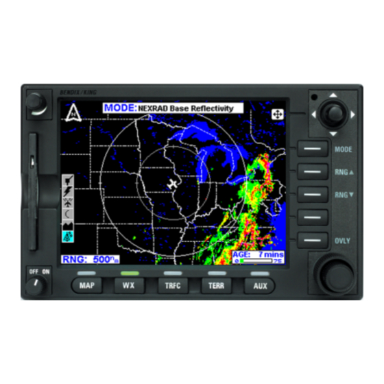
Page 28: Nexrad Page Operational Controls
MODE Key to obtain the NEXRAD Base Reflectivity display as shown in Figure NEXRAD Base Reflectivity will be displayed in the MODE field located at the top center of the display. Figure 19 Revision 2 Nov/2002 KMD 550/850 FIS Addendum... - Page 29 When the pointer reaches the edge of the display the map will pan to keep up with pointer movement. Release the joystick to stop moving the pointer. Press the RNG /RNG keys to zoom in or out on the pointer position. Revision 2 Nov/2002 KMD 550/850 FIS Addendum...
- Page 30 Stormscope™ is installed with the system. The FLIGHT PLAN and STORMSCOPE softkeys toggle the respective overlay on or off as in Figure 24. Figure 23 Figure 24 Revision 2 Nov/2002 KMD 550/850 FIS Addendum...
- Page 31 Normal Operation Press the SAVE & EXIT softkey to retain the selec- tions on the display (see Figure 25). Figure 25 Revision 2 Nov/2002 KMD 550/850 FIS Addendum...
-
Page 32: Graphical Metars Page
8 Aircraft Symbol - Indicates present aircraft position and heading (if available) or track. 9 METAR Color Key - Colors indicating flight rules pertaining to ceiling and visibility. Revision 2 Nov/2002 KMD 550/850 FIS Addendum... -
Page 33: Graphical Metars Page Operational Controls
2. Press the RNG /RNG Key to zoom in on the display. The map is centered on the present position indicated by the symbolic aircraft. Revision 2 Nov/2002 KMD 550/850 FIS Addendum... - Page 34 7. Press the RESET STICK softkey to return to the pre- Figure 29 sent position display. If no actions are taken for a period of 30 seconds, the display will return to the aircraft present position display. Revision 2 Nov/2002 KMD 550/850 FIS Addendum...
- Page 35 Figure 31). The FLIGHT PLAN softkey toggles the overlay on or off as in Figure 32. Press the SAVE & EXIT softkey to retain the selection on the display. Figure 31 Figure 32 Revision 2 Nov/2002 KMD 550/850 FIS Addendum...
-
Page 36: Fis Text Page
The bar will be green the first 50% then turn yellow. 14 Knob Function Label - Indicates the knob function is set to DATA input (USER DEFINED) or SCAN data (FLPN WPT). Revision 2 Nov/2002 KMD 550/850 FIS Addendum... -
Page 37: Fis Text Page Operational Controls
When the Control Knob function is set to DATA, the outer knob moves the cursor to the desired character in the desired field. The inner knob allows the selection of the desired letter or number in each field. Revision 2 Nov/2002 KMD 550/850 FIS Addendum... -
Page 38: Using The Fis Text Page
AREA). KIXD is also a reporting station which is listed first in the AVAILABLE REPORTS. Use the joystick to scroll through the AVAILABLE REPORTS. Urgent, special or amended reports will be highlighted in yellow. Revision 2 Nov/2002 KMD 550/850 FIS Addendum... - Page 39 Again, refer to Figure 36 to understand the rela- tionship between the selected AREA and the selected MODE. Revision 2 Nov/2002 KMD 550/850 FIS Addendum...
-
Page 40: Selecting Identifiers Using The Data/Scan Knob
1. The cursor will be over the first character of the waypoint identifier. Select the desired character by turning the inner knob. The screen will change to that shown in Figure 40. Figure 40 Revision 2 Nov/2002 KMD 550/850 FIS Addendum... - Page 41 6. Move the joystick right or left to view available reports. NOTE: Available reports highlighted in yellow, like KMCW in Figure 43, indi- cates the report is a special report, urgent report or an amended report. Figure 43 Revision 2 Nov/2002 KMD 550/850 FIS Addendum...
- Page 42 1. Turn the outer Control Knob one click clockwise. Figure 45 will be displayed. 2. Continue to turn the outer Figure 46 knob clockwise to highlight the N as shown in Figure 46. Revision 2 Nov/2002 KMD 550/850 FIS Addendum...
- Page 43 Turn the inner knob to select a G as in Figure 49. 6. Turn the outer knob clock- wise until the cursor is posi- tioned for the next desired character entry. Figure 48 Figure 49 Revision 2 Nov/2002 KMD 550/850 FIS Addendum...
- Page 44 This method is also used to Figure 52 choose the desired airport among those of identical names, but located in different cities. Revision 2 Nov/2002 KMD 550/850 FIS Addendum...
-
Page 45: Fis Network Status Page
Check Age indicates the station is operating, but may not be broadcasting the most recent information. Check the age of the data before using. Offline indicates the station is known to be offline. Revision 2 Nov/2002 KMD 550/850 FIS Addendum... - Page 46 WX Setup Cover Page as shown in Figure 54. 3. Press the FIS softkey to display the FIS Setup Cover Page as shown in Figure 55. Figure 53 Figure 54 Figure 55 Revision 2 Nov/2002 KMD 550/850 FIS Addendum...
- Page 47 Figure 57. NOTE: Visit Wingman Services www.ben- dixking.com to view the latest information about network Figure 57 transmitter locations and to cross-reference ground station IDs with the location names. Revision 2 Nov/2002 KMD 550/850 FIS Addendum...
-
Page 48: Messages
NO DATA RECEIVED Figure 58 FROM FIS RECEIVER If the KMD 550/850 display is unable to communicate with the KDR 510 VDL Receiver a message such as that shown in Figure 59 will be displayed. -
Page 49: Graphical Metars Not Available, Data Not Received
15 minutes or more since the last reception. The message can be cleared by pressing the OK softkey. The message will not appear again unless data is again received then again lost for 15 minutes. Revision 2 Nov/2002 KMD 550/850 FIS Addendum... -
Page 50: Metars Available, Data Not Received
Subscription Code. Cycling power to the unit and re-entering the code usually resolves the problem. If this message persists, the Figure 66 problem may be with the Database Card or the decryption hardware. Revision 2 Nov/2002 KMD 550/850 FIS Addendum... -
Page 51: Fis Decryption Failure, Unable To Accept A New Subscription Code
REVIEW YOUR SUB- Figure 68 SCRIPTIONS This message will be dis- played (Figure 69) if the system detects at least one subscription is within 7 days of it’s displayed ending date. Figure 69 Revision 2 Nov/2002 KMD 550/850 FIS Addendum... -
Page 52: Fis Alert, One Or More Fis Subscriptions Have Expired
VALID. UNABLE TO RECEIVE FIS DATA This message will be dis- played (Figure 72) if the system detects the system date is prior to the starting date of the data card. Figure 72 Revision 2 Nov/2002 KMD 550/850 FIS Addendum... -
Page 53: Fis Alert, Data Card Has Expired. Unable To Receive
DECRYPTION ERROR. UNABLE TO RECEIVE FIS DATA This message is similar in appearance to that shown in Figure 74. This message indicates that a decryption hardware failure has occurred after system startup and a successful self-test. Revision 2 Nov/2002 KMD 550/850 FIS Addendum... - Page 54 6. Visibility: 3/4SM R28R/2600FT 3/4 indicates 3/4 statute mile (SM) visibility. Runway Visual Range (RVR) for R28R (runway 28 right) is 2600 feet (2600FT). An “M” in this distance number indicates visibility is KMD 550/850 FIS Addendum Revision 2 Nov/2002 Appendix A...
- Page 55 Other possible designations could be as follows: Mist Dust Storm Widespread Dust Drizzle Funnel Cloud +FC Tornado/Water Spout Smoke Hail Small Hail/Snow Pellets Haze Ice Crystals Ice Pellets Dust/Sand Whirls Spray Sand KMD 550/850 FIS Addendum Revision 2 Nov/2002 Appendix A...
- Page 56 1. Type of Report: TAF TAF indicates a Terminal Area Forecast. TAF AMD indicates an amended forecast. 2. ICAO Station Identifier: KPIT This is the airport for which the TAF pertains. KMD 550/850 FIS Addendum Revision 2 Nov/2002 Appendix A...
- Page 57 The following is an example of a typical PIREP with an explanation of the elements. KCRW UA/OV KBKW 360015-KCRW/TM 1815/FL120/TP BE99/SK IMC/ WX RA/TA M08/WV 290030/TB LGT-MDT/IC LGT RIME/RM MDT MXD ICG DURGC KROA NWBND FL080-100 1750Z KMD 550/850 FIS Addendum Revision 2 Nov/2002 Appendix A...
-
Page 58: Appendix B, Common Weather Abbreviations
ACTV Active AGRD Agreed ACTVTY Activity AGRS Agrees ACYC Anticyclone AGRMT Agreement Adjacent Ahead Additional Alaska ADQT Adequate Alabama ADQTLY Adequately Aloft ADRNDCK Adirondack Along ADVCT Advect ALGHNY Allegheny ADVCTD Advected KMD 550/850 FIS Addendum Revision 2 Nov/2002 Appendix B... - Page 59 At or above Awaiting At or below Arizona Anomalous Azimuth Propagation Began APCH Approach BACLIN Baroclinic APCHG Approaching BAJA Baja, California APCHS Approaches BATROP Barotropic APLCN Appalachian British Columbia or APLCNS Appalachians patches KMD 550/850 FIS Addendum Revision 2 Nov/2002 Appendix B...
- Page 60 Blowing snow BINOVC Breaks in overcast BTWN Between Broken Beyond Blowing Celsius Build California or cloud- to-air lightning in BLDG Building PIREPs BLDUP Buildup Cold air advection BLKHLS Black Hills CARIB Caribbean KMD 550/850 FIS Addendum Revision 2 Nov/2002 Appendix B...
- Page 61 (lightning) CNTRD Centered Chance CNTRL Central CHCS Chances CNTY County Change CNTYS Counties CHGD Changed CNVG Converge CHGG Changing CNVGG Converging CHGS Changes CNVGNC Convergence Cloud-Height indicator CNVTN Convection CNVTV Convective KMD 550/850 FIS Addendum Revision 2 Nov/2002 Appendix B...
- Page 62 Decreases CRLN Circulation Delaware CRNR Corner Degree CRNRS Corners DEGS Degrees Course DELMARVA Delaware- Cirrostratus Maryland-Virginia CSDR Consider DFCLT Difficult CSDRBL Considerable DFCLTY Difficulty Coast DFNT Definite CSTL Coastal DFNTLY Definitely KMD 550/850 FIS Addendum Revision 2 Nov/2002 Appendix B...
- Page 63 DMSH Diminish DSND Descend DMSHD Diminished DSNDG Descending DMSHG Diminishing DSNDS Descends DMSHS Diminishes DSNT Distant Dense DSTBLZ Destabilize DNSLP Downslope DSTBLZD Destabilized DNSTRM Downstream DSTBLZG Destabilizing DNWND Downwind DSTBLZS Destabilizes KMD 550/850 FIS Addendum Revision 2 Nov/2002 Appendix B...
- Page 64 Earlier Downward vertical East-southeast velocity ESELY East-southeasterly DWNDFTS Downdrafts ESERN East-southeastern DWPNT Dew point ESEWD East-southeastward DWPNTS Dew points ESNTL Essential Dust (METAR) ESTAB Establish Drizzle (METAR) Estimate East EBND Eastbound KMD 550/850 FIS Addendum Revision 2 Nov/2002 Appendix B...
- Page 65 Extremely Falling EXTSV Extensive FLRY Flurry Fahrenheit FLRYS Flurries Aviation area fore- cast Flight Familiar Follow Funnel cloud (+FC FLWG Following = Tornado or water spout) From FCST Forecast FCSTD Forecasted KMD 550/850 FIS Addendum Revision 2 Nov/2002 Appendix B...
- Page 66 1/4 inch in diam- eter) FRST Frost GRAD Gradient FRWF Forecast wind factor GRDL Gradual Freeze GRDLY Gradually FRZLVL Freezing level Great FRZN Frozen GRTLY Greatly FRZG Freezing GRTLKS Great Lakes Feet FTHR Further KMD 550/850 FIS Addendum Revision 2 Nov/2002 Appendix B...
- Page 67 HRZN Horizon INCLG Including Heating INCLS Includes HURCN Hurricane INCR Increase HUREP Hurricane report INCRD Increased Have INCRG Increasing Heavy INCRGLY Increasingly HVYR Heavier INCRS Increases HVYST Heaviest INDC Indicate KMD 550/850 FIS Addendum B-10 Revision 2 Nov/2002 Appendix B...
- Page 68 INVRN Inversion LEVEL Level IOVC In overcast LFTG Lifting INVOF In vicinity of LGRNG Long-range Ice pellets Light Improve LGTR Lighter IPVG Improving LGWV Long wave ISOL Isolate Lifted Index KMD 550/850 FIS Addendum B-11 Revision 2 Nov/2002 Appendix B...
- Page 69 Maryland LTGCA Lightning cloud-to- MDFY Modify MDFYD Modified LTGCC Lightning cloud-to- MDFYG Modifying cloud Model LTGCG Lightning cloud-to- ground MDLS Models LTGCCCG Lightning cloud-to- Moderate cloud cloud-to- ground MDTLY Moderately KMD 550/850 FIS Addendum B-12 Revision 2 Nov/2002 Appendix B...
- Page 70 Moved Navigation MOVG Moving NAVAID Electronic naviga- MOVMT Movement tion aid facility (lim - ited to VOR or MOVS Moves VORTAC for Miles per hour PIREPs) MRGL Marginal New Brunswick KMD 550/850 FIS Addendum B-13 Revision 2 Nov/2002 Appendix B...
- Page 71 New Hampshire Northern None Narrow New Jersey Nova Scotia No layers No significant cloud Not later than No significant weather Northerly NTFY Notify New Mexico NTFYD Notified NMBR Number Nevada KMD 550/850 FIS Addendum B-14 Revision 2 Nov/2002 Appendix B...
- Page 72 OCRG Occurring OVTKS Overtakes OCRS Occurs Higher than Office greatest sensor value OFCM Office of the Federal Coordinator P6SM Visibility forecast to for Meteorology be greater than 6 statute miles KMD 550/850 FIS Addendum B-15 Revision 2 Nov/2002 Appendix B...
- Page 73 (wind, visibility, and/or sky condi- POSLY Positively tion) whose occur- rences are directly PPINA Radar weather related to, and con- report not available temporaneous with, the thunderstorm or precipitation event KMD 550/850 FIS Addendum B-16 Revision 2 Nov/2002 Appendix B...
- Page 74 Reach PTLY Partly RCHD Reached PTNL Potential RCHG Reaching PTNLY Potentially RCHS Reaches PTNS Portions RCKY Rocky PUGET Puget Sound RCKYS Rockies Positive vorticity advection RCMD Recommend Prevail RCMDD Recommended KMD 550/850 FIS Addendum B-17 Revision 2 Nov/2002 Appendix B...
- Page 75 Requests Rapid REQSTD Requested RPDLY Rapidly RESP Response RPLC Replace RESTR Restrict RPLCD Replaced Ragged RPLCG Replacing Regional model RPLCS Replaces RGLR Regular RPRT Report Region RPRTD Reported RGNS Regions KMD 550/850 FIS Addendum B-18 Revision 2 Nov/2002 Appendix B...
- Page 76 RTRNG Returning SCNDRY Secondary RTRNS Returns SCSL Stratocumulus Rough standing lenticular RUFLY Roughly Scatter Runway Visual SCTD Scattered Range SCTR Sector RVRNO RVR system not available South Dakota Revise Southeast KMD 550/850 FIS Addendum B-19 Revision 2 Nov/2002 Appendix B...
- Page 77 SNOINCR Snow increase SIGMET Significant meteoro- SNOINCRG Snow increasing logical information SNST Sunset SIMUL Simultaneous Standard operating Sky cover procedure Sky clear Snow pellets SKED Schedule Storm Prediction Center Solid KMD 550/850 FIS Addendum B-20 Revision 2 Nov/2002 Appendix B...
- Page 78 SUPR Superior ward SUPSD Supersede South-southwest SUPSDG Superseding SSWLY South-southwest- erly SUPSDS Supersedes SSWRN South-southwestern Serving SSWWD South-southwest- SVRL Several ward Southwest Stratus Southward STAGN Stagnation SWWD Southwestward STBL Stable KMD 550/850 FIS Addendum B-21 Revision 2 Nov/2002 Appendix B...
- Page 79 Type of aircraft THKST Thickest Topping Thin TRBL Trouble THNG Thinning TRIB Tributary THNR Thinner TRKG Tracking THNST Thinnest TRML Terminal Threshold TRMT Terminate THRFTR Thereafter TRMTD Terminated THRU Through TRMTG Terminating KMD 550/850 FIS Addendum B-22 Revision 2 Nov/2002 Appendix B...
- Page 80 Universal Time Coordinate Tower Urgent PIREP TWRG Towering Weather Reports Texas Upward vertical velocity Pilot weather reports UWNDS Upper winds UDDF Up- and downdrafts Varies Unable Virginia or Volcanic UNAVBL Unavailable KMD 550/850 FIS Addendum B-23 Revision 2 Nov/2002 Appendix B...
- Page 81 Weather ical conditions Weather Forecast Volume Office WFSO Weather Forecast Omnidirectional Service Office Radio Range Warm front passage VORT Vorticity Wisconsin VORTAC VOR and TACAN combination WIBIS Will be issued KMD 550/850 FIS Addendum B-24 Revision 2 Nov/2002 Appendix B...
- Page 82 Warming XPCS Expects Western XPLOS Explosive WRMR Warmer XTND Extend WRMST Warmest XTNDD Extended WRMFNT Warm front XTNDG Extending WRMFNTL Warm frontal XTRM Extreme WRNG Warning XTRMLY Extremely Worse Yesterday KMD 550/850 FIS Addendum B-25 Revision 2 Nov/2002 Appendix B...
- Page 83 Yukon YLSTN Yellowstone Zulu time Zone Zones KMD 550/850 FIS Addendum B-26 Revision 2 Nov/2002 Appendix B...
- Page 84 Honeywell International Inc. One Technology Center 23500 West 105th Street Olathe, KS 66061 Telephone (913) 782-0400 FAX 913-712-1302 © 2001, 2002 Honeywell International Inc. 006-18237-0000 Printed in U.S.A. Revision 2 November/2002...