Sign In
Upload
Manuals
Brands
Magellan Manuals
GPS
GPS 3000 XL
Magellan GPS 3000 XL Manuals
Manuals and User Guides for Magellan GPS 3000 XL. We have
1
Magellan GPS 3000 XL manual available for free PDF download: User Manual
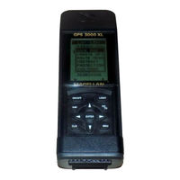
Magellan GPS 3000 XL User Manual (102 pages)
Magellan (Thales Navigation) Satellite Navigator User Manual
Brand:
Magellan
| Category:
GPS
| Size: 5.59 MB
Table of Contents
Warnings
2
License Agreement
2
Contents
5
Introduction
9
Packing List
9
Conventions Used in this Manual
9
Getting Started
11
GPS-3000 XL Description
11
Installing the Batteries
12
First Time Use
12
Initializing the Receiver
13
Initializing with Known Coordinates
15
Proper Handling-Signal Reception
17
Taking Your First Position Fix
18
Saving Your Position as a Waypoint
18
Saving a Waypoint with Different Coordinates
19
Introduction to Routes
19
Creating a Go to
20
Navigating with the GPS 3000 XL
20
Reference
21
Powering the GPS 3000 XL
21
Turning the Receiver off
22
Inputting Data
22
Turning the Display Light On/Off
22
Contrast
23
Using the GPS 3000 XL NAV Screens
24
Viewing the NAV Screens
24
Position Screen
25
NAV 1 Screen
25
Course Deviation Indicator (CDI)
26
NAV 2 Screen
27
Customizing the NAV Screens
27
Available Options Include
27
Customizing the NAV 1, 2 Screen
28
Pointer Screen
28
Plotter Screen
29
Deleting Plotter Track
30
Accessing Pan N Scan Functions
30
Creating a Waypoint from Pan N Scan
31
Viewing a Waypoint Message in Pan N Scan
31
Creating a Go to Route in Pan N Scan
31
Creating a Go to Coord from Pan N Scan
32
Road Screen
32
Viewing Destination Waypoint Messages
33
The Bell Icon Alert
33
Working with Waypoints
34
Saving a Position as a Waypoint
34
Saving the Position as a Waypoint (User-Created Name)
35
Attaching a Message to a Waypoint
35
Creating a Waypoint with User-Entered Coordinates
36
Viewing a Stored Waypoint
38
Viewing a Waypoint Message
39
Editing a Waypoint Message
39
Deleting a Waypoint Message
39
Projecting a Waypoint
40
Editing a Waypoint
41
Deleting a Waypoint
42
Using the Last Fix Buffer
43
Viewing the Last Fix Buffer
43
Copying a Last Fix as a Waypoint
43
Deleting a Last Fix
44
Working with Routes
45
Go to (Activating)
45
Creating a Mob Toute
46
Creating a Backtrack Route
46
Creating a Coordinate Go to Route
46
Accessing the Route Menu
47
Creating a Route
47
Deactivating a Route
49
Activating a Route
49
Reversing a Route
49
Editing a Route
50
Adding a Leg to the End of a Route
50
Inserting a Leg in a Route
51
Deleting a Leg from a Route
52
Replacing a Waypoint in a Route
52
Viewing a Leg in a Route
53
Activating a Leg of a Route
53
Deleting a Route
54
Using the Sun/Moon Screen
54
Accessing the Sun/Moon Screen
54
Tracking with the Trip Odometer
55
Accessing the Odometer Screen
55
Resetting the Odometer
55
Resetting the Trip Odometer
55
Clearing Memory with Clear Menu
56
Clearing All Last Fixes
56
Clearing Plotter Track
57
Clearing All Waypoints Arid Routes
57
Clearing All Memory
57
Customizing the GPS 3000 XL Satellite Receiver
58
Initializing
58
Selecting a Coordinate System
58
Selecting the Elevation Mode
59
Selecting Time Display and Changing the Time
59
Selecting Speed Units
60
Selecting Distance Units
60
Selecting Elevation Units
61
Selecting the North Reference
61
Selecting a Map Datum
62
Selecting NMEA Format
62
Selecting the Band Rate
63
Changing Waypoint Sorting Order
63
Setting the Plotter Orientation
64
Setting Plotter Track History
64
Adjusting Screen Contrast
65
Viewing the Status of Available Satellites
65
Viewing the Sat Status Screen
65
Simulating Navigation with the GPS 300 XL
66
Turning the Simulation Mode on
66
Icons
67
Warnings and Other Messages
68
Troubleshooting
70
Contacting Customer Service
71
Connecting External Power/Devices
72
Wiring List
72
Connecting to and External Antenna
73
Uploading/Downloading Waypoint Data
74
Swivel Mounting Bracket
75
To Install on a Dash Board or Other Horizontal Surface
75
To Install as a Wall-Mount
76
NMEA Data Messages
77
Data Transfer
77
Output Data Format
78
APA Autopilot Format a
78
APB Autopilot Sentence "B"
78
BWC to Selected Waypoint, Great Circle
79
GGA Global Position System Fix Data
79
GLL Geographic Position_Latitude/Longitude
80
RMB Generic Navigation Information (Immediately Follows RMC)
80
RMC Transit Specific (to be Followed by RMB)
81
VTG Actual Track and Ground Speed (SOG)
81
Available Datums
82
Specifications
83
Coordinate Systems
84
What Is GPS?
87
How Does GPS Work?
87
Accuracy
88
Dgps
88
Where to Get more Information
89
GPS Information Center
89
A Comprehensive Guide to Land Navigation with GPS
89
Other Books of Note
90
Abbreviations
91
City Reference Chart
92
Glossary
97
Index
99
Advertisement
Advertisement
Related Products
Magellan GPS 315
Magellan GPS 3000
Magellan GPS 320
Magellan GPS 300
Magellan Magellan GPS 310
Magellan GPS 4000 XL
Magellan GPS Receiver
Magellan GLOBAL SATELLITE TELEPHONE
Magellan GSC 100
Magellan 300GPS
Magellan Categories
GPS
Car Navigation system
Security System
Keypad
Receiver
More Magellan Manuals
Login
Sign In
OR
Sign in with Facebook
Sign in with Google
Upload manual
Upload from disk
Upload from URL