Sign In
Upload
Manuals
Brands
Lowrance Manuals
GPS
AirMap 2000c
Lowrance AirMap 2000c Manuals
Manuals and User Guides for Lowrance AirMap 2000c. We have
3
Lowrance AirMap 2000c manuals available for free PDF download: Operation Instructions Manual, Supplementary Manual
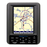
Lowrance AirMap 2000c Operation Instructions Manual (148 pages)
Aviation Mapping GPS Receiver
Brand:
Lowrance
| Category:
GPS
| Size: 3.89 MB
Table of Contents
Table of Contents
3
Sec. 1: Read Me First
7
Capabilities and Specifications
9
How Airmap Works
11
Introduction to GPS and WAAS
13
How to Use this Manual: Typographical Conventions
15
Sec. 2: Installation & Accessories
17
Power
17
Emergency Backup Batteries
17
Cigarette Lighter Power Adapter
19
MMC or SD Memory Card Installation
19
External Active Antenna
20
R-A-M Bracket Mounting System
22
Protective Bag
23
Protective Cover
24
Sec. 3: Aviation Operation
25
Keypad
25
Power/Lights (Turn Unit on and Off)
26
Main Menu
26
Satellite Status Page
29
Navigation Page
31
Compass Rose with HSI and OBS Hold
32
Map Page
37
Aviation GPS Quick Reference
45
Find Your Current Position
46
Moving Around the Map: Zoom & Cursor Arrow Keys
46
Selecting any Map Item with the Cursor
47
Searching
48
Find Nearest Airport (Shortcut)
50
Navigating to Nearest Airport with the Airmap
50
Setting a Waypoint
51
Navigate Back to a Waypoint
51
Navigate to Cursor Position on Map
52
Navigate to a Point of Interest
53
Go "Direct To" (Using the Direct to Button)
53
Airspace Status
54
Airport Information
54
Runways
55
Runway Approach Guidance Feature
56
Services
57
Transfer Custom Maps and GPS Data Files
58
Switch to Land Mode
60
Switch Back to Aviation Mode from Land Mode
60
Aviation Calculators
60
E6B Altitude/Airspeed Calculator
60
E6B Wind Speed/Direction Calculator
61
Vertical Navigation Calculator
62
Sec. 4: Land Operation
63
Keypad
63
Power/Lights (Turn Unit on and Off)
64
Main Menu
64
Satellite Status Page
65
Navigation Page
65
Map Page
66
Moving Around the Map: Zoom & Cursor Arrow Keys
67
Find Distance from Current Position to Another Location
67
Find Distance from Point to Point
68
Find Your Current Position
68
Icons
69
Create Icon on Map
69
Create Icon at Current Position
69
Delete an Icon
70
Load GPS Data Files from an MMC
70
Navigate
71
Navigate Back to man Overboard Waypoint
71
Cancel Navigation
71
Navigate a Route
71
Navigate to Cursor Position on Map
71
Navigate to an Icon
72
Navigate to Point of Interest (POI)
72
Navigate to a Waypoint
72
Navigate a Trail
72
Backtrack a Trail
74
Routes
74
Create and Save a Route
74
Delete a Route
77
Save GPS Data Files to an MMC
77
Searching
78
Switch to Aviation Mode
80
Switch Back to Land Mode from Aviation Mode
80
Trails
80
Create and Save a Trail
80
Delete a Trail
81
Edit a Trail Name
81
Transferring GPS Data
81
Transferring and Loading Custom Maps
81
Utilities
81
Alarm Clock
82
Sun/Moon Rise & Set Calculator
82
Trip Calculator
82
Trip down Timer
82
Trip up Timer
82
Waypoints
82
Create a Waypoint
82
Create a man Overboard Waypoint
83
Selecting a Waypoint
84
Delete a Waypoint
84
Edit a Waypoint (Name, Symbol, Position or Altitude)
84
Sec. 5: System & GPS Setup Options
85
Alarms
85
Aviation Alarms
86
Auto Satellite Search
87
Battery Indicator
88
Check MMC Files and Storage Space
88
Com Port Configuration
88
Coordinate System Selection
89
Map Fix
91
Customize Page Displays
92
GPS Simulator
93
Map Auto Zoom
94
Map Data
94
Show Map Data
95
Pop-Up Map Info
95
Map Boundaries
95
Fill Water with White
95
Map Overlays (Range Rings; Lat/Long Grid)
95
Map Detail Category Selection
96
Map Datum Selection
96
Map Orientation
97
Navionics Charts
98
Port Information
99
Tidal Current Information
100
Tide Information
102
Pop-Up Help
103
Reset Options
104
Set Language
106
Set Local Time
107
Software Version Information
108
Sounds and Alarm Sound Styles
108
Track Smoothing
109
Trail Options
110
Update Active Trail Option
110
Update Trail Criteria (Auto, Time, Distance)
110
Trail Update Rate (Time, Distance)
111
New Trail
111
Units of Measure
112
Sec. 6: Searching
115
Aviation Mode Searches
115
Find an Airspace (Using Cursor)
115
Find Airports (Aviation Mode Only)
116
Find Vors (Aviation Mode Only)
117
Find Ndbs (Aviation Mode Only)
119
Find Intersections (Aviation Mode Only)
121
Land Mode Searches
122
Find Addresses
122
Find any Item Selected by Map Cursor
124
Find Interstate Highway Exits
125
Find Map Places
126
Find Streets or (Street) Intersections
128
Find Waypoints
130
Sec. 7: Supplemental Material
133
Fcc Compliance
137
Index
139
How to Obtain Service
146
Accessory Ordering Information
147
Visit Our Web Site
148
Advertisement
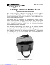
Lowrance AirMap 2000c Operation Instructions Manual (9 pages)
AirMap® Portable Power Pack
Brand:
Lowrance
| Category:
Power Pack
| Size: 1.78 MB
Table of Contents
Airmap PPP Components
2
Stowing for Transport
2
Battery Care
3
Battery Connections to Airmap
3
Power Leads Connected to the Battery Terminals
4
Airmap 2000C Connected to the Gel Cell Battery
5
Lowrance Electronics Full One-Year Warranty
7
How to Obtain Service
8
Accessory Ordering Information
8
Lowrance AirMap 2000c Supplementary Manual (4 pages)
Terrain Awareness Upgrade
Brand:
Lowrance
| Category:
GPS
| Size: 0.05 MB
Table of Contents
Installation
1
Operation
2
Color Code
2
Navigation Airspace Page
3
Map Window
3
Profile Window
3
Advertisement
Advertisement
Related Products
Lowrance GlobalNav 212
Lowrance iWAY 250C
Lowrance AirMap 500
Lowrance AirMap 300
Lowrance AirMap 600c
Lowrance AirMap
Lowrance AirMap 100
Lowrance 200
Lowrance SonicHub 2
Lowrance 1000
Lowrance Categories
GPS
Sonar
Fish Finder
Marine Equipment
Accessories
More Lowrance Manuals
Login
Sign In
OR
Sign in with Facebook
Sign in with Google
Upload manual
Upload from disk
Upload from URL