Sign In
Upload
Manuals
Brands
Humminbird Manuals
Fish Finder
386ci Combo
Humminbird 386ci Combo Fishfinder GPS Manuals
Manuals and User Guides for Humminbird 386ci Combo Fishfinder GPS. We have
1
Humminbird 386ci Combo Fishfinder GPS manual available for free PDF download: Operation Manual
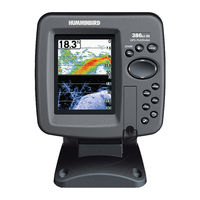
Humminbird 386ci Combo Operation Manual (180 pages)
300 series
Brand:
Humminbird
| Category:
Fish Finder
| Size: 6.15 MB
Table of Contents
Thank You
2
Table of Contents
4
Power on
13
How Sonar Works
14
Dualbeam PLUS Sonar
16
Down Imaging Sonar
17
Dual Beam Ice Transducer
18
How GPS Works
19
What Is on the 300 Series Control Head
20
Key Functions
21
Power/Light Key
21
View Key
22
Check/Info Key
22
Menu Key
22
4-Way Cursor Control Key
23
Mark Key
24
GOTO Key
24
Zoom Key
24
Exit Key
25
SD Card Slot
26
Add Maps to Your Fishfinder
27
Import Navigation Data
28
Export Navigation Data
28
To Export All Navigation Data
29
To Export Selected Navigation Items
29
Update Software
30
To Update the Control Head Software
31
What Is on the Sonar Display
32
Understanding the Sonar Display
34
Real Time Sonar (RTS) Window
34
Narrow RTS Window
34
Wide RTS Window
34
Sonar Colors and Bottom View
35
Sonar View: Original Palette
35
Structure ID
36
Whiteline
36
Switchfire
37
Freeze Frame and Active Cursor
37
Instant Image Update
37
What's on the down Imaging Display
38
Understanding down Imaging Display
40
Interpreting the Display
40
Down Imaging Sensitivity
41
Down Imaging Display: Freeze Frame and Active Cursor
41
Views
42
To Customize Your View Rotation
43
To Change the Digital Readouts
43
Sonar View
44
Sonar Zoom View
45
Split Sonar View
46
Big Digits View
47
Down Imaging View
48
Circular Flasher View
50
Ice Fishing Mode: off
51
Ice Fishing Mode: on
52
To Activate the Depth Cursor
53
To Activate Flasher Zoom
54
Snapshot and Recording View
55
Screen Snapshots
56
Make a Screen Snapshot/Delete a Screen Snapshot
56
View a Saved Screen Snapshot from Snapshot and Recording View
57
View a Saved Screen Snapshot from Chart View
57
Notes about Screen Snapshots
57
Recording and Playback
58
Start Recording
58
Stop Recording
58
Playback a Recording
59
Change Playback Settings
59
Stop Playback
59
Delete a Recording
59
Notes about Playback
60
Bird's Eye View
61
To Shift the Eye Point Position
61
Chart View
62
Shift/Pan
62
Zoom
62
Info
62
Chart View with Active Cursor Shown with Optional-Purchase Navionics Cartography
63
Chart/Sonar Combo View
64
Сhart/Down Imaging Combo View
65
Down Imaging/Sonar Combo View
66
X-Press Menu
66
Freeze Frame
66
Chart View Orientation
67
Viewing Cartography
68
Decluttered Waypoints
68
Introduction to Navigation
71
Waypoints, Routes, and Tracks
71
Open the Waypoint Management Dialog Box
73
What's on the Waypoint Management Dialog Box
74
Save, Create or Delete a Waypoint
76
Navigate to a Waypoint or Position
77
Add a Waypoint Target or Trolling Grid
78
Routes
79
Save the Current Route
79
Create a New Route
79
Travel a Saved Route
80
Edit the Waypoint Order in a Route
80
Tracks
81
Saver the Current Track/Clear the Current Track
81
Hide or Display/Delete a Saved Track
81
Review Route Information. Delete a Saved Route
81
Edit Your Waypoints, Routes, Tracks, and Groups
82
Edit a Waypoit, Route, Track or Group
83
The Menu System
84
Start-Up Options Menu
85
Normal
85
Simulator
86
System Status
86
Self Test
87
Accessory Test
87
GPS Diagnostic View
88
X-Press Menu Description
89
Main Menu
90
Quick Tips for the Main Menu
91
Note for All Menu Settings
91
User Mode (Normal or Advanced)
92
Sonar Tab Normal/Advanced Mode Diagrams
93
Sonar X-Press Menu
94
Cancel Navigation
95
Sensitivity
95
Upper Range
96
Lower Range
96
Chart Speed
97
Reset XTE
97
Bottom Range
98
Bottom Lock
98
Down Imaging X-Press Menu
99
Cancel Navigation Description
100
Down Sensitivity
100
DI Enhance
101
Upper Range (Advanced)
102
Lower Range Description
102
Chart Speed Description
103
DI Colors
103
Flasher X-Press Menu
104
Cancel Navigation Settings
105
Sensitivity Settings
105
Upper Range Settings
105
Lower Range Settings
106
Color Palette
107
Navigation X-Press Menu
108
Cancel Navigation (Only When Navigating)
109
Skip Next Waypoint
109
Waypoint (Name)
109
Cursor to Waypoint
110
Save Current Track
110
Clear Current Track
110
Save Current Route
110
Remove Target
111
Remove Grid
111
Sonar Window
111
Waypoint
111
Reset XTE Settings
112
Chart Declutter Settings
112
Snapshot and Recording X-Press Menu
113
Start Recording. Stop Recording
114
Delete Image
114
Delete All Images
114
Delete Recording
115
Delete All Recordings
115
Pings Per Second
115
Playback Speed
116
Stop Playback Settings
117
Alarms Menu Tab
118
Depth Alarm
119
Fish ID Alarm
119
Low Battery Alarm
119
Temp. Alarm
120
Off Course Alarm
120
Arrival Alarm
121
Drift Alarm
121
Alarm Tone
121
Timer Setup
122
Start Timer
122
Stop Timer
122
Sonar Menu Tab
123
Beam Select
124
Imaging Frequency
125
Surface Clutter Description
126
Switchfire Description
126
Fish ID+
127
Transducer Cone and Fish Arches Diagram
127
Fish ID Sensitivity Description
128
Real Time Sonar (RTS) Window Description
128
Sonar Colors
129
Bottom View
129
Zoom Width
130
83 Khz Sensitivity
130
455 Khz Sensitivity
130
Depth Lines
130
Depth Lines Diagram
131
Noise Filter
131
Max Depth
132
Water Type
132
Digital Depth Source
133
DI Pings
134
Ice Fishing Mode
135
DI Colors (down Imaging Views Only)
135
Navigation Menu Tab
136
Current Track
137
Waypoint, Routes, Tracks
138
Waypoint Settings
138
Saved Tracks Defaults
139
Chart Orientation
139
Casting Rings
139
North Reference
140
Waypoint Proximity Flags
140
Waypoint Decluttering
141
Trolling Grid Rotation
141
Trackpoint Interval
141
Track Min Distance
142
Track Color Range
142
Map Datum
142
North-Up Indicator
142
Course Projection Line
143
Continuous Navigation Mode
143
Chart Menu Tab
144
Lat/Lon Grid
145
Navaids on Bird's Eye View
145
Chart Select
145
Set Simulation Position
145
Set Map Offset
146
Clear Map Offset
146
Shaded Depth
146
Chart Detail Level
147
Map Borders
148
Spot Soundings
148
Auto Zoom
149
Auto Range
149
Vessel Offset
149
Offset Speed
150
Contour Lines
150
Depth Colors
150
Depth Highlight. Depth Highlight Range
150
Water Level Offset
151
Shallow Water Highlight
151
Lake List
151
Shallow Water Hightlight Chart View
152
Setup Menu Tab
153
Units - Depth
154
Units - Temp
154
Units - Distance. Units - Speed
154
User Mode
154
Language
155
Triplog Reset
155
Restore Defaults
155
Format Nav Directories
155
Select Readouts
156
Depth Offset
157
Temp. Offset
157
Default Sonar View
157
Sonar View with Select Readouts
157
Speed Calibration
158
Local Time Zone
158
Daylight Saving Time
158
Position Format
158
Time Format
159
Date Format
159
Digits Format
159
NMEA Output
160
Sonar Settings: Off/On
160
Demonstration
161
Sound Control
161
Screen Snapshot
161
Views Menu Tab
162
Control Head Maintenance
163
Transducer Maintenance
164
Troubleshooting
165
Fishfinder Doesn't Power up
165
Fishfinder Defaults to Simulator with a Transducer Attached
165
Display Problems
166
Finding the Cause of Noise
167
386Ci Specifications
168
386Ci DI Specifications
169
Glossary
171
GPS and Navigation Terms
175
Contacts
179
Advertisement
Advertisement
Related Products
Humminbird 385ci Combo
Humminbird 386ci DI Combo
Humminbird 385cxi Combo
Humminbird 323
Humminbird 300TX
Humminbird 300 series
Humminbird Legend 3005
Humminbird 325
Humminbird 345C
Humminbird 350TX TRI BEAM
Humminbird Categories
Fish Finder
GPS
Transducer
Marine Equipment
Sonar
More Humminbird Manuals
Login
Sign In
OR
Sign in with Facebook
Sign in with Google
Upload manual
Upload from disk
Upload from URL