
Related Manuals for Garmin Alpha 100 with TT 15


Summary of Contents for Garmin Alpha 100 with TT 15
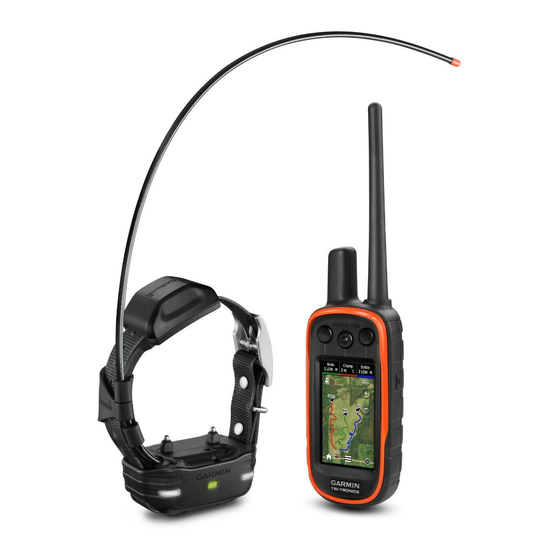
- Page 1 Alpha 100 with TT 15/TT 15 mini ™ ® Owner’s Manual July 2015 Printed in Taiwan 190-01786-00_0B...
- Page 2 All rights reserved. Under the copyright laws, this manual may not be copied, in whole or in part, without the written consent of Garmin. Garmin reserves the right to change or improve its products and to make changes in the content of this manual without obligation to notify any person or organization of such changes or improvements.
-
Page 3: Table Of Contents
Table of Contents Tracking a Contact ..............8 Finding Your Contact ID ............. 8 Changing Your Contact ID ............8 Getting Started............... 1 Updating a Contact ID ..............8 Setting Up the Alpha System ............1 Hunting with the Alpha System........8 Device Overviews ............... - Page 4 Satellite Page ................12 Changing the Satellite View ..........12 Turning Off GPS ..............12 Simulating a Location ............12 VIRB® Remote ................. 12 Controlling a VIRB Action Camera with Your Handheld Device .................. 12 Customizing Your Device..........12 Customizing the Main Menu ............. 12 Customizing the Data Fields .............
-
Page 5: Getting Started
(Adding a Dog Using Wireless Pairing, page Getting More Information Acquire satellite signals (Acquiring Satellite Signals, page You can find more information about this product on the Garmin ® website. Attach the collar (Fitting the Collar on Your Dog, page •... -
Page 6: Charging The Handheld Device
Charging the Handheld Device Turning On the Devices • On the handheld device, hold the power key until the NOTICE LCD display turns on. To prevent corrosion, thoroughly dry the USB port, the weather • On the dog collar device, hold the power key until the status cap, and the surrounding area before charging or connecting to LED flashes and the collar beeps. -
Page 7: Vhf Radio Information
See the product Select Dog List. packaging or go to www.garmin.com/tracking-legal for details Select a dog. about the radio frequency of this product. Select Show Info > Reset > Yes. -
Page 8: Changing The Dog Id
Changing the Dog ID Before you can change the dog ID, the collar must be turned on and within range of the handheld device. If you are experiencing interference from other collars or handheld devices in the area, you might need to change the ID for the dog. -
Page 9: Exit Sleep Mode
™ Before you can track your dogs and contacts using BaseCamp, you must download BaseCamp to your computer (www.garmin.com/basecamp). If necessary select to zoom in and out of the map. The BaseStation feature of BaseCamp allows you to track your... -
Page 10: Setting A Geofence Alert
A geofence is an invisible boundary around an area and is When you put the collar on the dog, make sure the contact created using points on the map. The virtual boundaries of a points are tight against the neck. geofence are accurate up to approximately 10 ft. -
Page 11: Customizing The Training Keys
Select to choose the intensity level for each of the feel certain that it is no longer needed to reinforce known stimulation keys. commands. Abandoning the collar too early can lead to problems in the future. If you are using traditional stimulation mode, select LOW, MED, or HI. -
Page 12: Sending A Message To Your Contacts
Sending a Message to Your Contacts Select New Hunt. Follow the on-screen instructions. You can send and receive automated messages. There are 18 messages choose from, such as "Help" and "I'm Coming." Marking a Covey Select > Contacts > Message. You can mark a covey location and enter the estimated number Select a message. -
Page 13: Repositioning A Waypoint To Your Current Location
Repositioning a Waypoint to Your Current Location Select Change Name. You can change the position of a waypoint. For example, if you Enter the new name, and select move your vehicle, you can change the location to your current Navigating a Saved Route position. -
Page 14: Viewing Details About The Track
Sending and Receiving Data Wirelessly Select a track. Before you can share data wirelessly, you must be within 10 feet (3 m) of a compatible Garmin device. Select View Map. You can share waypoints, geocaches, routes, and tracks The beginning and the end of the track are marked by flags. -
Page 15: Course Pointer
Course Pointer Select an individual point on the plot. The course pointer is most useful if you are navigating on water Details about the point appear in the upper-left corner of the or where there are no major obstacles in your path. It also helps plot. -
Page 16: Setting An Alarm
Overlay Service), or Demo Mode (GPS off). For more Select > Satellite > > Use With GPS Off. information about WAAS, go to http://www.garmin.com /aboutGPS/waas.html. Simulating a Location BaseCamp BaseStation: Sets how the device connects to Select > Satellite >... -
Page 17: Calibrating The Touchscreen
Battery Save: Saves the battery power and prolongs the battery Track Log: Turns track recording on or off. life by turning off the screen when the backlight times out Record Method: Sets a track recording method. Auto records (Turning On the Handheld Battery Save Mode, page 15). -
Page 18: Altimeter Settings
Long-term storage temperature From 32° to 77°F (from 0° to 25°C) range Garmin Express (www.garmin.com/express) provides easy access to these services for Garmin devices. VHF wireless range Up to 9 mi. • Product registration ANT+ low power wireless range About 10 ft. (3 m) -
Page 19: Tt 15 Dog Collar Device Specifications
You can adjust the backlight brightness to maximize *The device withstands pressure equivalent to a depth of 10 m. the battery life. For more information, go to www.garmin.com/waterrating. NOTE: The backlight brightness may be limited when the battery is low. -
Page 20: Saving Energy While Charging The Device
• GPX geocache files. Go to www.geocaching.com/play and the surrounding area before connecting the charging clip. • GPI custom POI files from the Garmin POI Loader. Go to www.garmin.com/products/poiloader. You can connect the collar to your computer to use with programs like BaseCamp. -
Page 21: Appendix
Installing the New Battery accessories. Before you replace the battery, you must remove the old battery • Bring the Garmin device within range 3 m (10 ft.) of the ANT+ (Removing the Old Battery, page 17). You also must have a accessory. -
Page 22: Replacing The Dog Collar Device Battery
Select the power key to test the connections. Replacing the Collar Strap Before you replace the collar strap, you must remove all dirt, When properly connected, a tone is emitted and the status water, and debris from the device (Cleaning the Device, LED blinks green. -
Page 23: Data Field Options
Rotate the end piece 90 degrees counter clockwise to GPS Signal Strength: The strength of the GPS satellite signal. unlock it. Heading: The direction you are moving. Heart Rate: Your heart rate in beats per minute (bpm). Your device must be connected to a compatible heart rate monitor. Location (lat/lon): The current position in latitude and longitude regardless of the selected position format setting. -
Page 24: Index
Sight 'N Go 11 fuse, changing 18 area calculation 11 software updates 14 updating 14 Garmin Express 14 backlight 12, 15 specifications 14, 15 registering the device 14 bark detection 4 stopwatch 12 updating software 14 BaseCamp 5, 12, 16 sunrise and sunset times 11 geofences 5, 6 battery 15 GPS 12... - Page 26 +34 93 275 44 97 +27 (0)11 251 9999 + 46 7744 52020 +886 2 2642-9199 ext 2 +49 (0) 89 858364880 0808 238 0000 zum Ortstarif - Mobilfunk +44 (0) 870 8501242 kann abweichen 913-397-8200 1-800-800-1020 © 2014 Garmin Ltd. or its subsidiaries...
Need help?
Do you have a question about the Alpha 100 with TT 15 and is the answer not in the manual?
Questions and answers