
Related Manuals for Flytec 6040


Summary of Contents for Flytec 6040
- Page 1 Flytec 6040 GPS / TT34 Operation Manual Firmware Vers.2.05f 11.05.2009 Revision: 11.07.2011...
-
Page 3: Table Of Contents
Operation Manual FLYTEC 6040 GPS Table of contents Operation ..........................3 Instrument overview ........................3 ..6040-GPS –Switch-on and switch-off....................4 ..1.2.1 Switch On ..........................4 1.2.2 Instrument Switch- off.......................4 Operation philosophy ........................5 ..Keypad .............................5 ..1.4.1 Function related key F1 and F2....................5 Display screen..........................6... - Page 4 Data exchange via PC........................42 ..6.1.1 Waypoints and Routes ......................43 6.1.2 Air Spaces ..........................43 Simulation ..........................43 Battery- Management ......................44 Transferring new software-(-firmware)to the Flytec 6040-GPS......... 45 Miscellaneous ........................46 10.1 Optional Software (additional Software)...................46 ..Additional Information ......................47 11.1 Altimeter............................47 ..
-
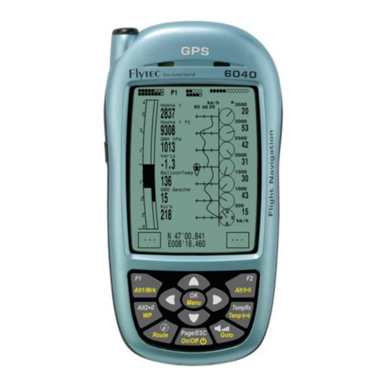
Page 5: Operation
Operation Manual FLYTEC 6040 GPS Operation Instrument overview Connection jack for wind Charging set Veh. Charge vane sensor (option) 110-230 V/AC cable 12V DC Antenna TT34 Receiver Loudspeaker Charger Jack Cover right side SD Card Slot USB Mini B USB Plug PC side chargin LED’s... -
Page 6: 6040-Gps -Switch-On And Switch-Off
Operation Manual FLYTEC 6040 GPS 6040-GPS –Switch-on and switch-off 1.2.1 Switch On The instrument is switched-on by pressing the On/Off key . Init EEPROM ↑ English Deutsch Francais By use of the ▲ or ▼ keys the required language may be selected. -
Page 7: Operation Philosophy
Operation Manual FLYTEC 6040 GPS Operation philosophy - white key lettering: all acoustic signal settings, the F1 / F2 key commands, the display screen shifts and an information request ( ) , can be made rapidly during the flight by short pressure on the key. -
Page 8: Display Screen
Operation Manual FLYTEC 6040 GPS Display screen The 6040 instrument offers three different display screens. After the switch-on display screen, the main display screen is automatically displayed Main display sreen Map display screen Windlayer display screen Km/h km/h Hoehe1 3500... -
Page 9: Shift Page Of Data Fields
Operation Manual FLYTEC 6040 GPS User defined data fields There are 7 data fields in the lower part of the display which may be allocated individually. In total more than 20 selectable data fields are at disposal. For list of data fields please refer to 1.7 - User defined data fields page 10. -
Page 10: Map Display Screen
Operation Manual FLYTEC 6040 GPS 1.5.2 Map display screen Air space Waypoint Analogue Track Variometer display Start Waypoint with cylinder Stanserhorn Altimeter Scale Digital variometer Vario Altitude Speed EnvelTemp Envelope Temp 2486 82.6 Function of F1 key Function of F2 key... -
Page 11: Windlayer" Display Screen
Operation Manual FLYTEC 6040 GPS Remark: any screen layout may take a few seconds according to the relevant data volume. The more Trackpoints are already stored in memory, the more time is required for the completion of screen layout. If a zoom or pan key is activated during the screen layout, the momentary layout process will be stopped and will resume with the new values. -
Page 12: Windlayer Page
Operation Manual FLYTEC 6040 GPS 1.6.1.2 Windlayer page km/h 1100 1100 Ascent phase 1000 After switch on, befor start, the scale is at its maximum of 100 m resolution. The start point is always between the two lowest scale units. When the top margin is reached... -
Page 13: User Defined Data Fields
Operation Manual FLYTEC 6040 GPS User defined data fields The main display page contains 3 pages each which are stepped forward by using the ► key. Thus it is possible to display almost all of the following measuring values in the right context. -
Page 14: The Setting Menus
Operation Manual FLYTEC 6040 GPS The Setting menus Long pressure on the MENU key gives access to setting mode. By use of ▼ and ▲ keys one of the Menu items is selected and by pressing the OK key access is given to the corresponding subdirectory. -
Page 15: User Settings
Operation Manual FLYTEC 6040 GPS 1.8.1.1 User Settings A series of settings allow the instrument to be programmed in accordance to the user’s wishes. Every pilot may realise his very own ideas here. All the basic settings may be set comfortably on the PC by use of the PC-Software „Flychart“... -
Page 16: Instrument Settings
Operation Manual FLYTEC 6040 GPS 1.8.1.3 Instrument Settings Term Denotation more Factory setting Info Display contrast Range 0.. 100 % 50 % TT34 Number Serial nb. Temperatur transitter Battery type Battery type. Selectable between Alcaline or Alcaline NiMH Time zone Difference to UTC;... -
Page 17: Flight Memory And Data Analysis
Operation Manual FLYTEC 6040 GPS 1.8.1.5 Flight Memory and Data analysis Flights are recorded in a Flash-Memory (see hereunder). Each Trackpoint contains time of day, position, GPS-altitude, barometric altitude as well as flight speed. In this way, it is possible to graph the Barogram, variogram, speed gram and course of the flight over a map for later evaluation. -
Page 18: First Steps
Operation Manual FLYTEC 6040 GPS First steps 1.9.1 Before first balloon flight Seite - Entry of pilot’s name, type and number of aircraft - Selection of recording interval - Settings of acoustics - Check accu and charge. If due to lack of time charging is not possible, they... -
Page 19: Functions
Operation Manual FLYTEC 6040 GPS Functions Altimeter and air pressure 2.1.1 How does an altimeter work? A barometric altimeter calculates altitude from the present air pressure of the atmosphere. Air pressure will decrease at increasing height. Due to the fact that air may be compressed, the pressure decrease is not linear, but indeed exponential. -
Page 20: Altimeter Alt1 (Absolute Altitude)
Operation Manual FLYTEC 6040 GPS 2.1.2 Altimeter Alt1 (absolute Altitude) Altimeter Alt1 is always the absolute altitude above sea level. The Alt1 display is permanently shown on the Main page as well as on the Map page. The Alt1 display is also shown in both user defined readout screens Altitude1m and Altitude1ft. -
Page 21: Altimeter Alt2, Relative Altitude (User Field)
Operation Manual FLYTEC 6040 GPS 2.1.3 Altimeter Alt2, Relative Altitude (User field) The altimeter Alt2 is in any case a difference altimeter. Thus it always displays the difference compared to such altitude at which it was reset to zero the last time. This function is often used for measuring the start site raising, or to recognise easily during flight under weak thermal lift the gain or loss in height. -
Page 22: Altitude Alert / Alarm
Operation Manual FLYTEC 6040 GPS 2.1.7 Altitude Alert / Alarm • In the altitude alert function two levels of alert can be set: one for a minimal and the other one for a maximal altitude. Depending on the setting of the alert level, a alarm can be programmed for undercutting or overcutting of an altitude or even for a certain altitude layer (bench ?) .In... -
Page 23: Variometer Functions
Acoustics generate a tone sequence dependent on the value data. The Vario-Acoustic corresponds always to the value of Analogue-Vario. The sink acoustic of the variometer can be adjusted in the FLYTEC 6040 instrument to the personal needs of the pilot. -
Page 24: Audio Level
Operation Manual FLYTEC 6040 GPS 2.2.3.1 Audio Level By use of the key Audio Level is adjusted the volume level of internal loudspeaker. Indeed for five values from soundless to maximum sound level. The selected value is displayed on the Info-line and is confirmed with a short beep or double-beep. -
Page 25: Speed
2.3.1 Wind vane sensor The wind vane sensor is one of the speed system of the 6040. The 6040 has an entry for reading out electronically the speed datas, which are measured by the vane sensors. Advantage of this system: Wind vane sensors already start measuring wind from 1 km/h very accurately. -
Page 26: Temperature
TT34 does not interferes with each other. In order to avoid interferences, each TT34 has an individual identity number (ID), which is being transmitted with the radio protocol. The 6040 instruments only accepts the radio dates, which are identical with the ID-number registrated in the 6040 instrument. -
Page 27: Maximum Temperature Alarm
Operation Manual FLYTEC 6040 GPS 2.6.1.2 Maximum Temperature Alarm The maximum envelope temperature is a default value recommended by the manufacturer and can not be manipulated. If the pilot reaches the maximum alarm level a temperature alarm will always go on. The alarm sound will be heard as a constant tone until the maximum envelope temperature is not reached any more. -
Page 28: Navigation
The FLYTEC 6030 GPS calculates several readouts by position determination made by GPS. Assesment of GPS Reception quality The FLYTEC 6030 GPS is fitted with a 16-channel GPS-Receiver which is featured with lesser power consumption and also a significantly shorter satellite detection time. Precision of position is between 7 to 40m. -
Page 29: Compass And Flight Direction
Operation Manual FLYTEC 6040 GPS Compass and flight direction In contrast to a standard magnetic compass which is oriented to the magnetic lines of force of the Globe, the GPS compass can show direction only when the user moves about. -
Page 30: Waypoints And Coordinates
Waypoints and Coordinates A waypoint is any single point on the earth’s surface that you would like to go to. The FLYTEC 6030 GPS can save up to 200 different waypoints. Each waypoint can have up to 17 characters, e.g. -
Page 31: Display Of Actual Coordinates
Main Setup Menu, as the list is rearranged again in the background over and over. 3.3.2 Display of actual coordinates If the FLYTEC 6040 receives satellites by GPS-Receiver, the actual position is displayed by briefly pressing the Info key in the instrument’s information field. After 20 sec. the previous display screen will automatically reappear. -
Page 32: Go-To - Function
(next WP) or ▼ (previous WP ). Altogether, the FLYTEC 6040-GPS can have up to 20 Routes created. Each Route may contain max. 30 WP’s. The one and same Waypoint can be used more than once along a Route, and the same Waypoint may be included on other Routes as well. -
Page 33: Creating A Route
F2 (Del.Route). For data safety the FLYTEC 6030 GPS inquires once again: “Delete Route?” which should be answered with “Yes” or “No”. Notice: Routes may also be set comfortably on the PC by use of the „Flychart 4.52“... -
Page 34: Flying Routes
Operation Manual FLYTEC 6040 GPS 3.4.4 Flying Routes The Menu Routes is enabled by long pressure on the Km/h Route key. After this selection the list of Routes stored in the instrument appears in the lower part of the screen. -
Page 35: Xt Error, Crosstrack Error
Operation Manual FLYTEC 6040 GPS 3.4.4.2 XT Error, Crosstrack Error This field indicates the shortest distance (perpendicular to the Track in relation to a map view) to the active leg of a Route. Pos 3 Waypoint Negative value Start Positive... -
Page 36: Map Of Flight Obstacles (Restricted Areas)
Operation Manual FLYTEC 6040 GPS Map of Flight Obstacles (Restricted areas) It is possible to enter on the FLYTEC 6040 GPS up to 300 flight obstacles such as CTR’s, TMA’s, air fields, danger areas, cables or also a wildlife protective area, of which the graphs are displayed on the map page. - Page 37 (to the right or to the left) in which these lines should be displayed later. The FLYTEC 6040 GPS draws automatically a line from the recent Waypoint to the first one. It is therefore not necessary to repeat as last waypoint the first one.
-
Page 38: Map Of Flight Obstacles - Edit With Flychart
Air Space files which had been downloaded. Flytec/Bräuniger Air Spaces ending with *.txt or*.fas can be edited with any text editor, or very comfortably with the Flychart Air Space editor. Start point and end point do not need to be identical. Start point and end point do not need to be identical. -
Page 39: Downloading Air Spaces
“Store” (memorise). These Air Spaces are not subject to be edited. 4.2.2.3 Selection of Air Spaces The standard version of FLYTEC basic list allows selection of up to 20 Restricted Areas for transmission to the instrument, storage and for being called up again. The upgraded version allows selection of up to 300 Restricted Areas for transmission to the instrument, storage and for being downloaded to the instrument. -
Page 40: Editing Air Spaces
Operation Manual FLYTEC 6040 GPS After having called up this function it is at first required to click into the list in order to activate all Air Spaces contained in the list. The graph is displayed in the right side part of the screen. - Page 41 Long, Lat centre; Radius in km. We recommend the following procedure: • Select with the button „Download“ ( "Laden") a FLYTEC Air Space file (*.fas, *.fa5 or *txt). You will now receive a long list and a complex graph. •...
-
Page 42: Flight-Memory And Flight-Analysis
The recording mode does not need to be specifically activated, as each flight is automatically saved. Main Setup Menu The flight memory used on the FLYTEC 6040 GPS not only ------------------ records flight altitude and flight speed (TAS), but it also logs the position of the pilot and the GPS-altitude ⇒... -
Page 43: Graphic Display Of Flights In Map Format
Operation Manual FLYTEC 6040 GPS Caution: make sure before take-off that the GPS-Receiver indicates to receive at least 4 Satellites in order to achieve valid recordings. Comment 1: in the Flight Analysis are displayed max. values which occured during the flight. -
Page 44: Data Transfer
Data exchange via PC The basic equipment of the FLYTEC 6030 GPS includes a data cable for a USB PC interface USB Mini Due to this feature the data transfer can be carried out in both directions. The data transmission is effected via serial interface COMX with: 57.600 baud;... -
Page 45: Waypoints And Routes
Operation Manual FLYTEC 6040 GPS 6.1.1. Flight instrument Options All settings can be performed or altered comfortably with Flychart 4.52 Benutzereinstellungen und Instrument Einstellungen Wegpunkte Lufträume 6.1.1 Waypoints and Routes In the same menu the way points and the routes can also be transfered from the Flychart to the instrument. -
Page 46: Battery- Management
WP becomes smaller while at the same time the altitude is naturally decreasing. If you now initiate a climb with the ▲ key, the FLYTEC 6040 GPS simulates circling up in a thermal; the compass rose turns and the distance to goal continuously changes between somewhat closer and somewhat farther away. -
Page 47: Transferring New Software-(-Firmware)To The Flytec 6040-Gps
2 pieces each per Bank NiMH Accumulators 2100mAh or more, 1.2V size AA. Estimated operation time 2 times 15h = 30h in total (delivery status). In case of need, e.g. if the accumulators may not be charged in time, the FLYTEC 6040 GPS will also work with standard Alkaline batteries! 2 pieces each per Bank Alkaline High Power Batteries 1.5V size AA. -
Page 48: Miscellaneous
10 Miscellaneous 10.1 Optional Software (additional Software) By means of an activation code which is available from Flytec, it is possible to enable additional special functions. For example by use of a 5-digit Code to activate the NMEA output. Procedure for Code entry: •... -
Page 49: Additional Information
In this position the FLYTEC 6030 GPS should not have more than 45° deviation from horizontal position so that the antenna points upwards. -
Page 50: Accuracy Of Gps Altitude
Operation Manual FLYTEC 6040 GPS 11.2.2 Accuracy of GPS Altitude A good explanation on the GPS Altitude accuracy is found on the following website: http://www.kowoma.de/en/gps/errors.htm First of all the word accuracy has to be defined. On the website mentioned above you can read: “The declaration of the accuracy used by Garmin for their GPS receivers leads sometimes to confusion. - Page 51 The GPS module in the FLYTEC instruments makes no time filtering over the horizontal position, but at good reception it performs a filtering of around 5 seconds in the vertical position. The poorer the GPS...
-
Page 52: Flight Memory And Igc File
Operation Manual FLYTEC 6040 GPS 11.3 Flight Memory and IGC File 11.3.1 Content of IGC File In the IGC File are saved all important data of a flight in readable format. One can edit the IGC File by using any desired Editor. - Page 53 Operation Manual FLYTEC 6040 GPS Select standard format for columns The present head in lines 1 – 13 contains internal flight data. These are no longer needed any more and can be erased . Zum besseren Verständnis sind Inhalt und Einheit der Spalten beschriftet.
-
Page 54: Evidence Of Flights - Security Against Manipulation
Operation Manual FLYTEC 6040 GPS 11.3.2 Evidence of flights – Security against manipulation The FAI (Fédération Aéronautique Internationale) and its subgroup IGC (International Gliding Committee) require a recording format which, while memorising continuously the time of day, position and also the flight altitude, substitutes the barograph. When transmitting flight data to the pilot’s PC, a so-called IGC-File is created, which receives a digital signature (=G-Record), authenticating the flight data and making it fraud-resistant. -
Page 55: Maintenance
In regard to the legal fact that it is solely the pilot who has the responsibility performance of his flights, the Company FLYTEC AG shall reject any claim on damage resulting from data loss or wrong data of your instrument. -
Page 56: Technical Data
Technisches Manual Flytec 6040 Anhang 14 Technical Data Altimeter: max. 11000 m Scale 1m Variometer: analogue ± 8 m/s Scale. 0,2 m/s digital ± 100 m/s Scale 0,1 m/s Speed Pitot pressure 0 - 100 km/h Wind wheel 0 up to 120 km/h (Sensor in option) Waypoints: 200 WP’s... -
Page 57: Attachment
Technisches Manual Flytec 6040 Anhang 16 Attachment 16.1.1 Mounting instruction for the Radio Temperatur Transmission Unit Funksensor TT34 ca. 1m Circular Top Opening (Parachute) Der Temperatursender sollte ungefähr 1Meter unterhalb desTop's montiert werden MontagepunktTT34 Ballonhülle Vertikale Lastgurte der Ballonhülle Klettband (Schlingenseite) Klettband (Hakenseite) ca.
Need help?
Do you have a question about the 6040 and is the answer not in the manual?
Questions and answers