Table of Contents
Advertisement
Quick Links
Advertisement
Table of Contents

Related Manuals for Globalsat SiRF star III BT-359


Summary of Contents for Globalsat SiRF star III BT-359
- Page 1 User Manual Bluetooth GPS Receiver BT-359 Ver 1.1...
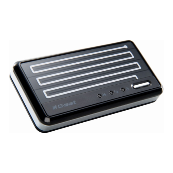
- Page 2 1. BT-359 at a glance Appearance and Function 1. Bluetooth Status LED 2. GPS Status LED 3. Power LED 4. Power Button How to change battery Accessories Car charger BT-359 USB cable Travel charge adapter (optional)
-
Page 3: Power Saving Function
2. Introduction The BT-359 is a GPS receiver with Bluetooth interface and built-in active antenna for high sensitivity to tracking signal. Based on the SiRF star III Low power chip set and supports all functions (Single Sat updates in reduced visibility, Superior urban canyon performance, FoliageLock for weak signal tracking, etc.). -
Page 4: Auto Shut-Off Function
2.5 Auto Shut-Off Function By default, your BT-359 has a built-in timer that will automatically power down your BT-359 GPS receiver whenever it looses the Bluetooth paring connection to the host device for more than 10 minutes. This will help to keep you from returning to a dead GPS battery in the event you accidentally might have left the vehicle and forgot to turn off the GPS. -
Page 5: System Specification
3. Specification System Specification Electrical Characteristics GPS standard SiRF StarⅢ GPS Antenna Built-in ceramic patch antenna Bluetooth standard Bluetooth V2.0 Operation range 10 meters (33 feet) Bluetooth Default PIN 0000 Operation time Up to 11 hrs Charge time 4~5 hrs Auto Shut-Off When no active Bluetooth connection has been detected within 10 minutes. -
Page 6: Gps Specification
GPS Specification Electrical Characteristics GPS Chipset SiRF Star III Frequency L1, 1575.42 MHz C/A Code 1.023 MHz chip rate Channels 20 channel all-in-view tracking ACCURACY Position Horizontal 10 meters, 2D RMS 1-5 meters 2D RMS, WAAS corrected Velocity 0.1m/sec Time 1 micro-second synchronized to GPS time DATUM Datum... - Page 7 4. Usage 4.1. For PDA with built-in Bluetooth 1. Turn on the power switch in BT-359. 2. Please refer to the user manual of PDA to enable the Bluetooth of PDA connecting to the BT-359. Some PDAs may need the Bluetooth passkey, the passkey is “0000”.
-
Page 8: How To Test Your Bluetooth Gps Receiver
5. How to test your Bluetooth GPS Receiver? The testing program only supports the Microsoft Windows CE & Pocket PC based PDA platform. 1. Run the “GPSinfo.exe” to execute the installation procedure of testing program (via PC and ActiveSync). 2. Run the “GPS Information” program from “Start → Program files” of PDA. Here is the description of “GPS Information”... -
Page 10: Troubleshooting
Will the GPS work with other Street Mapping software? Globalsat GPS receivers provide standard NMEA data for mapping software to use and convert to coordinates and should work well with most any NMEA compliant software on the market today. -
Page 11: Fcc Notices
If your PC is on and the COM port was configured properly, the GPS receiver is on and receiving the streaming GPS data. This can be verified by opening your mapping software program. In addition, the Globalsat GPS has a built-in LED status indicator that shows the following: LED OFF: GPS receiver is off (no power).
Need help?
Do you have a question about the SiRF star III BT-359 and is the answer not in the manual?
Questions and answers