Table of Contents
Advertisement
Advertisement
Table of Contents

Related Manuals for Garmin Foretrex 201


Summary of Contents for Garmin Foretrex 201
- Page 1 Foretrex ™ ® personal navigator owner’s manual...
- Page 2 Information in this manual is subject to change without notice. Garmin reserves the right to change or improve its products and to make changes in the content without obligation to notify any person or organization of such changes. Visit the Garmin Web site (www.Garmin.com) for current updates and supplemental information concerning the use and operation of this and other Garmin products.
-
Page 3: Introduction
Thank you for choosing the Garmin Foretrex 201. To get the most from your new Foretrex 201, read through the Quick Start Guide first, then this Owner’s Manual to under- stand all of the operating features. The Quick Start Guide describes the process of navigating the Main Pages and the Option Menus, along with some basic unit operations to familiarize you with your new Foretrex 201 right out of the box. -
Page 4: Compliance, License, And Warranty Information
The Foretrex 201 does not contain any user-serviceable parts. Repairs should only be made by an authorized Garmin service center. Unauthorized repairs or modifications could result in permanent damage to the equipment and void your warranty and your authority to... -
Page 5: Warranty Information
Software are valuable trade secrets of Garmin and that the Software in source code form remains a valuable trade secret of Garmin. You agree not to decompile, disassemble, modify, reverse assemble, reverse engineer or reduce to human readable form the Software or any part thereof or create any derivative works based on the Soft- ware. -
Page 6: Limited Warranty
This Garmin product is warranted to be free from defects in materials or workmanship for one year from the date of purchase. Within this period, Garmin will at its sole option repair or replace any components that fail in normal use. Such repairs or replacement will be made at no charge to the customer for parts or labor, provided that the customer shall be responsible for any transportation cost. - Page 7 The unit should then be sent, freight charges pre- paid, to any Garmin warranty service station. A copy of the original sales receipt is required as the proof of purchase for warranty repairs.
-
Page 8: Safety Information
Introduction Warnings and Precautions WARNING: If you choose to use the Foretrex 201 in a vehicle, it is the sole responsibility of the owner/operator of the Foretrex 201 to secure the GPS unit so that it will not cause Safety Information damage or personal injury in the event of an accident. - Page 9 State of California to cause cancer, birth defects, or reproductive harm. This Notice is being provided in accordance with California’ s Proposition 65. If you have any questions or would like additional information, please refer to our Web site at www.garmin.com/prop65.
-
Page 10: Cleaning The Unit And Wrist Strap
After submersion, be certain to wipe and air dry the unit before reuse or charging. To resolve problems that cannot be remedied using this guide, contact Garmin Product Support in the U.S.A. at 800/800.1020 or Garmin Europe at 44/1794.519944. -
Page 11: Table Of Contents
Introduction...i-x About This Manual ...i Compliance, License, and Warranty Information...ii FCC Compliance ... ii Software License Agreement ... iii Product Registration ... iii Limited Warranty ... iv Safety Information ... vi Warnings and Precautions ... vi Cleaning the Unit and Wrist Strap .. viii Storing the Foretrex 201 ... -
Page 12: Table Of Contents
Introduction Table of Contents Projecting a Waypoint ... 26 Hunting and Fishing Information ... 27 Sun and Moon Information ... 28 Tracks Menu Page...29 Tracks Menu Page ... 29 Using the Track Log ... 30 Pan Options ... 30 Using the Setup Track Page ... 31 Using Saved Tracks ... -
Page 13: Overview
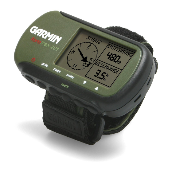
Foretrex 201 Overview Your small, rugged, and waterproof Foretrex 201 unit is perfect for easily maneuver- ing from one waypoint to the next. With handy and convenient wrist-strap design, the powerful Foretrex 201 allows you to store up to 500 waypoints and 20 routes in the unit’ s memory. -
Page 14: Using The Buttons
Overview Getting Started foretrex 201 Using the Buttons goto POWER GOTO PAGE button: POWER • Press and hold to turn unit on and off • Press and release to turn display backlight on and off • Press and hold , then simultaneously press PAGE button: GOTO... -
Page 15: Using The Wrist Strap
Using the Wrist Strap The Foretrex 201 has been designed to comfortably fit your wrist. For best perfor- mance, wear the Foretrex 201 like a watch, with the top face of the unit oriented towards the sky. A strap extension provides additional length and easily attaches to the existing strap. - Page 16 Overview Getting Started To remove the wrist strap from the Foretrex 201: 1. Place your Foretrex 201 on a cloth or soft surface to avoid scratching the case. 2. While holding the Foretrex 201 steady with one hand, use a jeweler’s band pin removing tool or a very soft flat head screwdriver.
-
Page 17: Charging The Battery
Charging the Battery The Foretrex 201 operates on a rechargeable lithium-ion battery. This battery lasts as long as 15 hours when fully charged. To charge the battery: 1. Wipe the contacts dry, if needed. 2. Snap the Cradle to the unit with the 4-contact end in first (shown in the top image to the right). -
Page 18: Turning On The Foretrex 201
Overview Getting Started Turning on the Foretrex 201 After the Foretrex 201 is completely charged, it is ready for use. Allow the Foretrex 201 time to track satellites and determine your position the first time you use it. Upon startup, the GPS signal bar appears. -
Page 19: Using The Main Pages
Using the Main Pages All of the information needed to operate the Foretrex 201 is found on six main ‘pages’ (or display screens). These pages are the Satellite, Map, Navigation, Trip Computer, Timer (if enabled), and Main Menu. Switching Between the Main Pages Simply press the PAGE button to switch between pages as shown below. -
Page 20: Main Pages
Main Pages Satellite Page Satellite Page Satellite Page Options Advanced Satellite Page Using the Satellite Page The Satellite Page shows the Foretrex 201 gathering all the necessary satellite informa- tion in order to work. The Satellite Page shows you the satellites being acquired (in anima- tion), satellite signal strength, and the Foretrex 201 unit’... -
Page 21: Adjusting The Backlighting And Contrast
Adjusting the Backlighting and Contrast If the lighting conditions make it hard for you to see the screen, adjust the contrast or turn on the backlight. You may also make these adjustments through the Main Menu Page. See the “Setup Menu: Set Display” section on page 46 for more information. To use the backlight: 1. -
Page 22: Map Page
Main Pages Map Page Map Page Map Page Options Using the Map Page The Map Page shows where you are (the animated figure) and provides a picture of where you are going. As you travel (the animated figure ‘walks’) and leaves a ‘trail’ (track log). - Page 23 Map Setup: Press when this is highlighted to adjust the map settings including: ENTER Orient Map (Ahead or Northward): When ‘AHEAD’ is selected, the top of the map is oriented in the direction you are currently moving. When ‘NORTHWARD’ is selected, the map is always oriented to the North.
- Page 24 Main Pages Map Page Clearing the Track Log Measure Distance Page Edit Number Page To clear the track log from the Map Page: 1. Press the button while on the Map Page to display the Map Page Options. ENTER 2. Press the DOWN button to highlight ‘CLEAR TRACK LOG’...
-
Page 25: Navigation Page
Using the Navigation Page The Navigation Page helps guide you to a destination. When you are moving with no particular destination in mind, the Navigation Page shows you your moving direction and speed. When you are moving towards a specific destination (navigating a course), the Navigation Page displays the name of the location, two data fields (that display distance to final destination and speed by default), and a direction arrow in the compass ring. -
Page 26: Trip Computer
Main Pages Trip Computer Trip Computer: Four small data fields Trip Computer Options Using the Trip Computer The Trip Computer stores information for your trip from the time it is reset until it is re- set again. The Trip Computer displays information about your trip, such as your maximum speed and trip odometer. -
Page 27: Timer Page
Displaying the Timer Page By default, the Timer Page is not displayed. You must access the Main Menu and enable the Timer Page before you can display and use it. To enable the Timer Page: 1. Press the PAGE button until the Main Menu Page is displayed. 2. - Page 28 Main Pages Timer Page Set Timer Page: Timer Defaults Setting the Count Down From field Edit Time Page To set the Timer: 1. Press the button until the Main Menu Page is displayed. PAGE 2. Use the DOWN buttons to highlight ‘SETUP’ and press 3.
-
Page 29: Using The Timer Page
Using the Timer Page After the Timer Page is enabled and a count down time is entered, you can use the timer for a variety of applications, such as running and sailboat racing. The synchronization and quick reset capabilities make the Foretrex an extremely handy timer. To stop and start the timer: 1. -
Page 30: Main Menu Page
Main Pages Main Menu Page Main Menu Page Waypoints Menu Main Menu Page Basics The Main Menu Page gives you access to the Foretrex 201 unit’ s waypoints, tracks, routes, and setup screens. When the Main Menu Page is displayed, use the buttons to highlight the desired sub-page (Waypoints, Tracks, Routes, or Setup), and press ENTER to open that page. -
Page 31: Waypoints Menu Page
Waypoints Menu Page The Waypoints Menu Page provides access to your waypoints and allows you to delete and create waypoints. To open the Waypoints Menu Page: 1. From the Main Menu Page, use the 2. Press the ENTER button to access the Waypoints Menu Page. To create a waypoint: 1. - Page 32 Main Pages Waypoints Menu Page Waypoints Menu To view the nearest waypoints page: 1. From the Main Menu Page press the then press the button. ENTER 2. Select ‘NEAREST’ and press the ENTER waypoints by name and distance from your location. Nearest Waypoints Page 3.
-
Page 33: Marking A Waypoint
Marking a Waypoint The Mark Waypoint Page, shown to the left, allows you to define a location as a waypoint and then change the waypoint symbol, name, elevation, and location (latitude and longitude). Entering a known location, then saving it as a Waypoint, works well for geocaching. - Page 34 Main Pages Waypoints Menu Page Mark Waypoint Page Changing the waypoint symbol Edit Waypoint Name Page To change the symbol: 1. From the Main Menu Page press the button to display the Mark Waypoint Page. ENTER 2. Press the DOWN button and highlight the symbol in the flag.
- Page 35 To change the elevation: 1. From the Main Menu Page press the button to display the Mark Waypoint Page. ENTER 2. Press the DOWN button and highlight the ‘ELEV’ field and press the button to display the ENTER CORRECT ELEVATION Page. 3.
-
Page 36: Review Waypoint Page
Main Pages Waypoints Menu Page Review Waypoint Page Delete Waypoint Page Waypoint on Map Review Waypoint Page The Review Waypoint Page allows you to change the waypoint symbol, name, eleva- tion and location (just as on the Mark Waypoint Page). You can also delete the waypoint, display the waypoint on the Map Page, start a GOTO, and display the Review Waypoint Page Options. - Page 37 To start a GOTO from the Review Waypoint Page: 1. On the Review Waypoint Page, press the 2. Press the ENTER button to activate the ‘GOTO’ with the selected waypoint as the destination. To start a GOTO using the GOTO Button: 1.
-
Page 38: Projecting A Waypoint
Main Pages Waypoints Menu Page Waypoint Options Project Waypoint Page Edit Number Page Projecting a Waypoint Using the Project waypoint feature, the Foretrex 201 can create a waypoint at a specified distance and bearing using an existing waypoint as a reference. You can also change the waypoint name, symbol and elevation on this page. -
Page 39: Hunting And Fishing Information
Hunting and Fishing Information This feature provides you with a listing of best times for hunting and fishing for the chosen waypoint and date. To display the hunting and fishing information: 1. Press the Page button to access the Main Menu. Press the Enter button when ‘Waypoints’... -
Page 40: Sun And Moon Information
Main Pages Waypoints Menu Page Waypoint Options Sun and Moon Page Changing the date Sun and Moon Information This feature provides you with a list of sun rise/set and moon rise/set times for the se- lected waypoint for the current date. A graphic display of the moon phase is also displayed. You may view Sun and Moon information for any date. -
Page 41: Tracks Menu Page
Tracks Menu Page The Foretrex 201 draws an electronic breadcrumb trail or ‘track log’ on the Map Page as you travel. The Track Log contains information about points along its path, including time, and position. The Foretrex 201 uses this information to allow you to navigate using the saved track. -
Page 42: Using The Track Log
Main Pages Tracks Menu Page Tracks Menu Page Panning the Track Log Using the Track Log To use the track log, select the ‘PAN TRACK LOG’ option to show a pointer that moves along the track log when you press the To Pan the track log: 1. -
Page 43: Using The Setup Track Page
Main Pages Using the Setup Track Page Recording: Turn the track log recording ‘ON’ and ‘OFF’. Record Interval: You can set the track recording interval to change based on ‘DISTANCE’, Tracks Menu Page ‘TIME’, or ‘AUTO’. If ‘DISTANCE’ or ‘TIME’ is selected, enter a value (a specific distance or time) in the next field. - Page 44 Main Pages Tracks Menu Page Tracks Menu Page Saved Tracks List Delete All Saved To save a track: 1. Press the PAGE button to access the Main Menu. Press the ‘TRACKS’ is highlighted to open the Tracks Menu Page. 2. Highlight ‘SAVE TRACK’ and press ENTER 3.
-
Page 45: Track Page Options
Main Pages Track Page Options From the Saved Tracks List, highlight a track and press to display the options for ENTER that track. Tracks Menu Page Navigate: Press ENTER to navigate this track. Select to begin navigation from the begin- ning point or the end point. -
Page 46: Routes Menu Page
Main Pages Routes Menu Page Routes Menu Page New Route Page Add Point to Route Page Routes Menu Page Route navigation allows you to create a sequence of intermediate waypoints that lead you to your final destination. The Foretrex 201 stores 20 routes, each with up to 125 waypoints. The Routes Menu Page provides access to your routes and allows you to delete and create routes. -
Page 47: Using The Route Page
Using the Route Page Each route saved in your Foretrex 201 is displayed in the Routes List. You can then access each route displayed in its own individual Route Page. From the Route Page you can edit the route, delete the route, and follow the route. To select a route from the List All page: 1. -
Page 48: Deleting All Routes
Main Pages Routes Menu Page Routes Menu Page Deleting All Routes You can quickly delete all routes from the Route Menu Page. This is especially helpful after a vacation where the stored routes no longer apply to your location. You can also delete points within the route. -
Page 49: Route Setup
Route Setup You may alter the way your Foretrex follows routes. To access Route Setup: 1. From the Main Menu Page, use the 2. Press the ENTER button to access the Routes Menu Page. 3. Use the DOWN buttons to highlight ‘Setup Routes’ and press Route Setup Options Route Leg Transition: Select a method to start guiding you to the next leg of the route. -
Page 50: Editing A Route
Main Pages Routes Menu Page Route Page Edit Route Name Editing the Route Name Editing a Route You can edit many elements of a route, such as the route name and the route order. You can add waypoints at any point along the route. You can also remove waypoints from the route. - Page 51 To insert a waypoint in the route: 1. With the Route Page displaying, use the you would like to enter the new waypoint before. Press the 2. Use the DOWN buttons to highlight ‘INSERT’ then press 3. Use the UP, DOWN, ENTER buttons to select the desired waypoint in the Add Point to Route Page.
-
Page 52: Navigating A Route
Features Routes Menu Page Route Page Inserting a waypoint Route with new waypoint added Navigating a Route A Route can be navigated using the Map Page or the Navigation Page. The Map Page displays your movement, the route line, and waypoints on the route. The Navigation Page shows the direction you need to travel using the pointer in the compass. -
Page 53: Setup Menu: Set Timer
Using the Setup Menu The Setup Menu allows you to setup several aspects of the Foretrex 201, such as the timer, display, interface, and system. You must access the Setup Menu and then select one of the options in the Setup Menu to access the individual Setup Pages. The Setup Menu contains the following pages: Set Timer, Set Time, Set Display, Set Units, Set Heading, Set Interface, and Set System. -
Page 54: Setting The Timer
Features Setup Menu: Set Timer Set Timer Page Setting the Count Down From field Edit Time Page Setting the Timer You can set the timer to count down from a particular time. For example, if you are in a race that has a two-minute warning before the start, program your Foretrex to count down from two minutes. -
Page 55: Expired And Interval Timer Tones
To set the expired action: 1. Press the button until the Main Menu Page is displayed. PAGE 2. Use the DOWN buttons to highlight ‘SETUP’ and press 3. Use the DOWN buttons to highlight ‘SET TIMER’ and press 4. Use the buttons to highlight the field below ‘STOP’... -
Page 56: Setup Menu: Set Time
Main Pages Setup Menu: Set Time Setup Menu Set Time Page Setting the time zone Set Time Page The Time Page allows you to select a 12-hour or 24-hour time format, enter the proper time zone, and choose Daylight Savings Time. When you select 12-hour time formatting, the clock will read like a standard clock with 12-hour AM and 12-hour PM cycles. -
Page 57: Daylight Savings Time
Daylight Savings Time Daylight savings time can be set to ‘AUTOMATIC’ (using the built-in almanac to auto- matically change the clock settings when daylight savings goes into or out of effect). You can choose ‘YES’ to manually add daylight savings or ‘NO’ to remain on standard time. To change the daylight saving field: 1. -
Page 58: Setup Menu: Set Display
Main Pages Setup Menu: Set Display Setup Menu Set Display Page Selecting the light timeout Set Display Page Light Timeout The ‘LIGHT TIMEOUT’ option allows you to set the display backlight timeout (stays on, 15 or 30 seconds, and 1 or 2 minutes) and to adjust the display contrast. To change the light timeout: 1. -
Page 59: Setup Menu: Set Units
Foretrex 201 supports both the UTM/UPS and latitude/longitude grids, which define posi- tion location for the entire globe. For more information about using paper maps with your Garmin unit, refer to “Using a Garmin GPS with Paper Land Maps”, available for download at http://www.garmin.com/manuals/UsingaGarmtinGPSwithPaperLandMaps_Manual.pdf. -
Page 60: Map Datums
Main Pages Setup Menu: Set Units Set Units Page Selecting the Map Datum Map Datums A map datum is a reference model of the earth’ s shape. Every map uses a map datum which is usually listed in the title block of the map. The default datum in the Foretrex 201 is WGS 84 (World Geodetic Survey, 1984). -
Page 61: Distance/Speed, Elevation, And Vertical Speed
Distance/Speed, Elevation, and Vertical Speed The Foretrex 201 allows you to customize speed and distance readouts. To change the Distance/Speed, Elevation, or Vertical Speed: 1. Press the PAGE button until the Main Menu Page is displayed. Use the buttons to highlight ‘SETUP’ and press 2. -
Page 62: Setup Menu: Set Heading
Main Pages Setup Menu: Set Heading Setup Menu Set Heading Page Selecting the angle setting Set Heading Page You can set the angle units and the North Reference in the Set Heading Page. Angle: Select the unit of measurement for angles to display in. Highlight ‘DEGREES’ and press ENTER to display angle units as degrees (360°). -
Page 63: Setup Menu: Set Interface
If ‘GARMIN DGPS’ or ‘RTCM/NMEA’ format is selected, additional fields are provided to control a GARMIN differential beacon receiver (e.g. GBR 21 & GBR 23) directly from your unit. In the ‘BEACON’ list, select ‘SCAN’ to tune automatically, or select ‘USER’ to manually tune the receiver and enter the beacon frequency and bit rate. -
Page 64: Setup Menu: Set System
Owner Information and reset the unit to the defaults. Setup Menu: Set System GPS Mode: Enable (‘NORMAL’) and disable (‘OFF’) the GPS Receiver. You can also enable WAAS, Battery Save, or Demo modes. See the following page. -
Page 65: Gps Mode
GPS Mode Select from the following modes: Normal: The GPS receiver is always ‘ON’ when it’ s in ‘NORMAL’ mode. The normal mode is more responsive to sudden turns or change of speed/acceleration. WAAS: The Wide Area Augmentation System (WAAS) capability produces a more accurate position fix. -
Page 66: Appendix
Appendix Specifications Physical Case: Fully-gasketed, high-impact plastic alloy, waterproof to IEC 60529 IPX7 standards (waterproof to 1 meter for 30 minutes) Size: 1.71” H x 3.26” W x .69” D Weight: Approx. 2.75 ounces (78g) Temperature Range: -4° to 140° F (-20° to 60° C) (operating) Performance Receiver: Differential-ready, 12 parallel channel... -
Page 67: Data Field Options
Appendix By pressing the button, you can change the Data fields on the right side of DOWN the Navigation Page: Bearing—The direction from your current location to a destination. Data Field Options Course—The direction from your starting location to a destination. Elevation—The altitude (height) above or below sea level. - Page 68 Appendix Next ETA—The estimated time of day you will reach the next waypoint on the route. Next ETE—The estimated time elapsed until you reach the next waypoint on the route. Data Field Options Odometer—A running tally of distance travelled, based upon the distance between second- by-second position readings.
-
Page 69: Index
All Waypoints 20, 36 Final ETE 55 Route 35 Follow a Route 35 Saved Tracks 32 Tracks 12 Waypoint 24 GARMIN 51 Destination 13 DGPS 51 Display Timer 15, 41 Getting Started 1 GOTO 2, 11, 24, 25, 26, 30 GPS 6... - Page 70 Index Moonrise 28 Moonset 28 Lat/Lon 55 Moon Phase 28 Latitude 21, 23, 47, 55 Moving Average 55 Light Timeout 46 Moving Time 55 Lithium-ion battery 5 Location 23, 55 Longitude 21, 23, 47, 55 Name a Waypoint 22 Navigate 11, 33, 40 Route 40 Main Menu Page 18 To a Waypoint 25...
- Page 71 Show Timer 15, 41 Times Specifications 54 Hunting and Fishing 27 Speed 56 Sunrise and Sunset 28 Start the TImer 17 Time Format 44 Stop Navigation 11, 13 Time Page 44 Stop the Timer 17 Time Zone 44 Stop Time 56 Tones 43 Storage viii Total Time 56...
- Page 72 For the latest free software updates (excluding map data) throughout the life of your Garmin products, visit the Garmin Web site at www.garmin.com. © Copyright 2004 Garmin Ltd. or its subsidiaries Garmin International, Inc. 1200 East 151 Street, Olathe, Kansas 66062, U.S.A.
Need help?
Do you have a question about the Foretrex 201 and is the answer not in the manual?
Questions and answers