Garmin DRIVESMART 66 Owner's Manual
Hide thumbs
Also See for GARMIN DRIVESMART 66:
- Owner's manual (24 pages) ,
- Owner's manual (64 pages) ,
- Owner's manual (52 pages)
Table of Contents
Advertisement
Quick Links
Advertisement
Table of Contents

Related Manuals for Garmin GARMIN DRIVESMART 66


Summary of Contents for Garmin GARMIN DRIVESMART 66
- Page 1 GARMIN DRIVESMART 66/76/86 ™ Owner’s Manual...
- Page 2 © 2021 Garmin Ltd. or its subsidiaries All rights reserved. Under the copyright laws, this manual may not be copied, in whole or in part, without the written consent of Garmin. Garmin reserves the right to change or improve its products and to make changes in the content of this manual without obligation to notify any person or organization of such changes or improvements. Go to www.garmin.com...
-
Page 3: Table Of Contents
Device Overview........1 Vehicle Power Adapter Overview..2 Finding and Saving Locations..16 Mounting Considerations....... 2 Finding a Location Using the Search Mounting and Powering the Garmin DriveSmart 66/76 Device in Your Bar............17 Vehicle..........3 Finding an Address....... 17 Mounting and Powering the Garmin Location Search Results...... - Page 4 Assigning Categories to a Saved Viewing Upcoming Traffic....33 Location..........24 Viewing Traffic on the Map....33 Deleting a Saved Location....24 Searching for Traffic Incidents..33 Customizing the Map......34 Following a Route......25 Customizing the Map Layers... 34 Routes........... 25 Changing the Map Data Field...
- Page 5 Removing the Device, Mount, and Saving a Traffic Camera....41 Suction Cup........... 51 Wireless Cameras......... 41 Removing the Device from the Pairing the Camera with a Garmin Mount..........51 Navigation Device......42 Removing the Mount from the Suction Viewing the Wireless Camera..42 Cup.............
- Page 6 Index..........56 Table of Contents...
-
Page 7: Getting Started
• Update the maps and software on your device (Map and Software Updates, page 48). • Mount the device in your vehicle and connect it to power (Mounting and Powering the Garmin DriveSmart 66/76 Device in Your Vehicle, page • Acquire GPS signals (Acquiring GPS Signals, page •... -
Page 8: Vehicle Power Adapter Overview
Vehicle Power Adapter Overview NOTICE The vehicle power adapter included with your Garmin DriveSmart 66/76/86 device is not compatible with any other Garmin devices. Connecting this vehicle power adapter to a different device could cause damage to the ® device. -
Page 9: Mounting And Powering The Garmin Drivesmart 66/76 Device In Your Vehicle
Mounting and Powering the Garmin DriveSmart 66/76 Device in Your Vehicle WARNING This product contains a lithium-ion battery. To prevent the possibility of personal injury or product damage caused by battery exposure to extreme heat, store the device out of direct sunlight. - Page 10 Getting Started...
-
Page 11: Mounting And Powering The Garmin Drivesmart 86 Device In Your Vehicle
Mounting and Powering the Garmin DriveSmart 86 Device in Your Vehicle WARNING This product contains a lithium-ion battery. To prevent the possibility of personal injury or product damage caused by battery exposure to extreme heat, store the device out of direct sunlight. -
Page 12: Pairing With Your Smartphone
1 From the app store on your smartphone, install the Garmin Drive app. 2 Turn on your Garmin DriveSmart device, and place the device and your smartphone within 3 m (10 ft.) of each other. 3 On your phone, open the Garmin Drive app. - Page 13 For each audio type, you can select Vehicle to play that audio type from your stereo through the Bluetooth connection, or you can select Garmin Device to play that audio type from the device speaker or auxiliary output cable.
-
Page 14: Connecting To The Stereo Using An Auxiliary Audio Cable
3.5 mm stereo auxiliary audio cable. NOTE: This feature is not available for all product models. 1 Connect one end of the audio cable to the 3.5 mm audio output jack on the Garmin DriveSmart power cable plug. -
Page 15: Acquiring Gps Signals
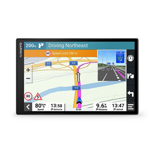
36). Current time. Select to set the time (Setting the Time, page 46). Battery charge level. Garmin Drive app connection status (Pairing with Your Smartphone, page Temperature. Select to view the weather forecast (Viewing the Weather Forecast, page 39). Using the On-Screen Buttons On-screen buttons allow you to navigate the pages, menus, and menu options on your device. -
Page 16: Adjusting The Volume
• To enable the device to play a tone when it starts listening to a voice request, select the Start of Voice Request check box. When you press the voice button or say OK, Garmin or Alexa, the device plays a tone to indicate it is listening for your request. -
Page 17: Voice-Activated Features
When using this feature, you should focus on driving and only use this feature when it is safe to do so. The Garmin Drive app must be open and running on your compatible smartphone to use Alexa features and access live services. -
Page 18: Starting A Route
Going to a Saved Location Using Your Voice It is useful to start a route on your Garmin DriveSmart device each time you travel to a saved location, even though you may already know how to get there. Your device can help you avoid reported traffic delays and construction that may affect your route. -
Page 19: Changing Device Settings Using Your Voice
• Alexa, will it snow in Chicago this weekend? Enabling Skills You can enable additional skills by speaking to your Garmin DriveSmart device, or by using the Amazon Alexa app. • To enable a skill using your voice, say a phrase like Alexa, enable the Pandora skill.. -
Page 20: Music Player
• To get information about the currently playing song, say Alexa, what song is this? Adding Music Accounts You can use the Amazon Alexa app to connect your Garmin DriveSmart to your streaming music service accounts, such as Amazon Music service or Pandora ®... -
Page 21: Muting The Microphones
The driver alerts and speed limit features are for information only and do not replace your responsibility to abide by all posted speed limit signs and to use safe driving judgment at all times. Garmin is not responsible for any traffic fines or citations you receive for failing to follow all applicable traffic laws and signs. -
Page 22: Enabling Or Disabling Driver Alerts
2 Select or clear the check box next to each alert. Red Light and Speed Cameras NOTICE Garmin is not responsible for the accuracy of or the consequences of using a red light or speed camera database. NOTE: This feature is not available for all regions or product models. -
Page 23: Finding A Location Using The Search Bar
Finding a Location Using the Search Bar You can use the search bar to search for locations by entering a category, brand name, address, or city name. 1 Select Where To?. 2 Select Search in the search bar. 3 Enter all or part of the search term. Suggested search terms appear below the search bar. -
Page 24: Location Search Results
Location Search Results The location search results appear in a list, with the nearest location at the top. Each numbered location also appears on the map. You can scroll down to view more results. Select a location to view the option menu. Select to view detailed information about the location. -
Page 25: Changing The Search Area
Changing the Search Area By default, the device searches for locations near your current location. You can also search other areas, such as near your destination, near another city, or along your active route. 1 Select Where To?. 2 Select next to the current search area 3 Select a search area. -
Page 26: Finding National Parks
Foursquare location details, check in to a location, and search for points of interest in the online Foursquare database. Connecting to Your Foursquare Account Before you can use this feature, your device must be connected to a supported phone running the Garmin Drive (Live Services, Traffic, and Smartphone Features, page 34). -
Page 27: Tripadvisor
Foursquare Account, page 20). Select Where To? > Foursquare®. Viewing Foursquare Location Details Before you can use this feature, your device must be connected to your Foursquare account using the Garmin Drive app (Connecting to Your Foursquare Account, page 20). -
Page 28: Finding An Intersection
• To start a route to the coordinates, select Go!. Finding Fuel Stations and Prices Before you can use this feature, your device must be connected to a supported phone running the Garmin Drive (Pairing with Your Smartphone, page You can find nearby fuel stations and compare fuel prices. -
Page 29: Understanding Parking Colors And Symbols
Understanding Parking Colors and Symbols Parking locations that include detailed parking data are color-coded to show the likelihood of finding parking. Symbols indicate the type of parking available (street or lot), relative pricing information, and payment type. You can view the legend for these colors and symbols on the device. From the parking search results, select Viewing Recently Found Locations Your device stores a history of the last 50 locations you have found. -
Page 30: Saving Locations
Saving Locations Saving a Location 1 Search for a location (Finding a Location by Category, page 19). 2 From the search results, select a location. 3 Select > Save. 4 If necessary, enter a name, and select Done. 5 Select Save. Saving Your Current Location 1 From the map, select the vehicle icon. -
Page 31: Following A Route
Following a Route Routes A route is a path from your current location to one or more destinations. • The device calculates a recommended route to your destination based on the preferences you set, including the route calculation mode (Changing the Route Calculation Mode, page 29) and avoidances (Avoiding Delays, Tolls, and Areas, page... -
Page 32: Your Route On The Map
Your Route on the Map As you travel, the device guides you to your destination using voice prompts and information on the map. Instructions for your next turn or exit, or other actions appear across the top of the map. Distance to the next action. -
Page 33: Active Lane Guidance
Active Lane Guidance As you approach some turns, exits, or interchanges in your route, a detailed simulation of the road appears beside the map, if available. A colored line indicates the proper lane for the turn. Viewing Turns and Directions While navigating a route, you can view upcoming turns, lane changes, or other directions for your route. -
Page 34: Parking Near Your Destination
Parking Near Your Destination Your device can help you find a parking spot near your destination. When you approach some destinations, the device automatically suggests parking areas. 1 Select an option: • When the device suggests parking, select More to see all suggested parking areas. NOTE: When you select a suggested parking area, the device automatically updates your route. -
Page 35: Taking A Detour
Taking a Detour You can take a detour for a specified distance along your route or detour around specific roads. This is useful if you encounter construction zones, closed roads, or poor road conditions. 1 From the map, select > Edit Route. 2 Select an option: •... -
Page 36: Avoiding Environmental Zones
Avoiding Environmental Zones Your device can avoid areas with environmental or emissions restrictions that may apply to your vehicle. 1 Select Settings > Navigation > Environmental Zones. 2 Select an option: • To be asked each time before routing through an environmental zone, select Always Ask. •... -
Page 37: Using The Map
Using the Map You can use the map to navigate a route (Your Route on the Map, page 26) or to view a map of your surroundings when no route is active. 1 Select View Map. 2 Touch anywhere on the map. 3 Select an option: •... -
Page 38: Up Ahead
Up Ahead The Up Ahead tool provides information about upcoming locations along your route or the road on which you are traveling. You can view upcoming points of interest by category, such as restaurants, fuel stations, or rest areas. You can customize the categories that show in the Up Ahead tool. Viewing Upcoming Locations 1 From the map, select >... -
Page 39: Viewing The Trip Information Page
• Select Reset Trip B to reset the odometer. Viewing Upcoming Traffic NOTICE Garmin is not responsible for the accuracy or timeliness of the traffic information. Before you can use this feature, your device must be receiving traffic data (Traffic, page 38). -
Page 40: Customizing The Map
• Select 3-D to display the map in three dimensions. Live Services, Traffic, and Smartphone Features The Garmin Drive app allows your device to receive smart notifications and live information, such as live traffic data and weather information. Garmin voice-activated navigation: Allows you to use voice commands to search for locations and addresses,... -
Page 41: Showing Or Hiding Notification Categories (Iphone )
Do not read or reply to notifications while driving. If you do so, you could become distracted by the display, which could lead to an accident causing serious personal injury or death. Before you can use this feature, your device must be connected to a supported phone running the Garmin Drive (Live Services, Traffic, and Smartphone Features, page 34). -
Page 42: Viewing The List Of Notifications
Do not read or reply to notifications while driving. If you do so, you could become distracted by the display, which could lead to an accident causing serious personal injury or death. Before you can use this feature, your device must be connected to a supported phone running the Garmin Drive (Live Services, Traffic, and Smartphone Features, page 34). -
Page 43: Receiving A Call
Disconnecting a Bluetooth Device You can temporarily disconnect a Bluetooth device without deleting it from the paired devices list. The Bluetooth device can connect to your Garmin DriveSmart device automatically in the future. 1 Select Settings > Wireless Networks. 2 Select the device to disconnect. -
Page 44: Deleting A Paired Phone
Data Using Your Smartphone, page 38). Traffic data is not available in all areas. For information about traffic coverage areas, go to garmin.com/traffic. Receiving Traffic Data Using Your Smartphone Your device can receive subscription-free traffic data while connected to a smartphone running the Garmin Drive app. -
Page 45: Viewing The Weather Forecast
• To add a favorite city, select Add City, and enter a city name. Viewing the Weather Radar Before you can use this feature, your device must be connected to a supported phone running the Garmin Drive (Live Services, Traffic, and Smartphone Features, page 34). -
Page 46: Planning A Route
Planning a Route A route can include many locations, and it must include at least a starting location and one destination. The starting location is the location from which you plan to start your route. If you start navigating the route from a different location, the device gives you the option to route to your starting location first. -
Page 47: Editing And Saving Your Active Route
3 Select Save to save your route, which you can navigate again later (optional). photoLive Traffic Cameras Before you can use this feature, your device must be connected to the Garmin Drive app (Live Services, Traffic, and Smartphone Features, page 34). -
Page 48: Pairing The Camera With A Garmin Navigation Device
The camera remains in pairing mode for two minutes. If pairing mode expires, you can remove and reinstall the batteries. 3 Bring the compatible Garmin navigation device outside your vehicle and within 1.5 m (5 ft.) of the camera, and turn on the navigation device. -
Page 49: Viewing Previous Routes And Destinations
This allows you to use the parking stall lines at the rear of the vehicle as reference points for alignment. 2 From the paired Garmin navigation device, select Settings > Wireless Cameras. 3 Select the paired camera name, and select Guidance Lines > Adjust Guidance Lines. -
Page 50: Settings
Sets which installed maps the device uses. Enabling Maps You can enable map products installed on your device. TIP: To purchase additional map products, go to buy.garmin.com. 1 Select Settings > Map Display > myMaps. 2 Select a map. -
Page 51: Wireless Network Settings
Alerts: Sets the type of proximity points for which alerts are played. Backup Camera Settings The backup camera settings allow you to manage paired Garmin backup cameras and camera settings. This menu appears on your navigation device only when the device is connected to a wireless camera receiver cable. -
Page 52: Display Settings
Display Settings Select Settings > Display. Orientation: Allows you to set the display to portrait (vertical) or landscape (horizontal). NOTE: This feature is not available on all product models. Color Mode: Allows you to select day or night color mode. If you select the Auto option, the device automatically switches to day or night colors based on the time of day. -
Page 53: Device And Privacy Settings
Device and Privacy Settings Select Settings > Device. About: Displays the software version number, the unit ID number, and information on several other software features. Regulatory: Displays regulatory markings and information. EULAs: Displays the end-user license agreements. NOTE: You need this information when you update the system software or purchase additional map data. Software Licenses: Displays software licensing information. -
Page 54: Charging The Device
• Connect the device to an optional power adapter accessory, such as a wall power adapter. You can purchase an approved Garmin AC-DC adapter suitable for home or office use from a Garmin dealer or www.garmin.com. The device may charge slowly when connected to a third-party adapter. -
Page 55: Updating Maps And Software Using A Wi-Fi Network
TIP: If a map update is interrupted or canceled before it completes, your device may be missing map data. To repair missing map data, you must update the maps again using either Wi‑Fi or Garmin Express. Device Maintenance... -
Page 56: Updating Maps And Software With Garmin Express
Updating Maps and Software with Garmin Express You can use the Garmin Express application to download and install the latest map and software updates for your device. 1 If you do not have the Garmin Express application installed on your computer, go to garmin.com/express... -
Page 57: Device Care
1 On your computer, go to garmin.com/express. 2 Select an option: • To view the system requirements and verify the Garmin Express application is compatible with your computer, select System Requirements. • To install on a Windows computer, select Download for Windows. -
Page 58: Removing The Mount From The Suction Cup
• If you want to connect to your vehicle stereo using the Garmin DriveSmart auxiliary audio output, verify each of these items: ◦ Verify that a 3.5 mm audio cable is connected to the audio output jack in the Garmin DriveSmart power cable plug and to the auxiliary input jack for your vehicle stereo... -
Page 59: I Cannot Adjust The Screen Brightness On My Device
While the Garmin DriveSmart device is turned on and the microphones are not muted, the device continuously listens for you to say OK, Garmin or Alexa to start a request. The device itself does not record or store any audio data. -
Page 60: My Device Does Not Connect To My Phone
Garmin mapping software. The device supports microSD memory cards from 4 to 32 GB. Memory cards must use the FAT32 file system format. Memory cards greater than 32 GB must be formatted using the device. -
Page 61: Transferring Data From Your Computer
3 Select a file. 4 Select Edit > Copy. 5 Browse to a folder on the device. NOTE: For a removable drive or volume, you should not place files in the Garmin folder. 6 Select Edit > Paste. Disconnecting the USB Cable If your device is connected to your computer as a removable drive or volume, you must safely disconnect your device from your computer to avoid data loss. - Page 62 Foursquare 20, 21 settings 44 deleting 30 fuel next turn 26 disabling 30 prices 22 notifications 34–36 road 30 stations 23 road features 29 tolls 29 on-screen buttons 9 Garmin Connect 34 owner's manual 38 Garmin Express 51 backup camera 43, 45. See cameras updating software 50 battery going home 12, 25 pairing charging 3, 5, 48 GPS 9, 55 disconnecting 37...
- Page 63 viewing on the map 26, 27 wireless camera 45 satellite signals acquiring 9 viewing 55 saved locations 12, 40 categories 24 deleting 24 editing 24 saving, current location 24 screen, brightness 10, 53 screenshots 46 search bar 17 settings 44, 46, 47 sound 10 shaping a route 28 shortcuts adding 23 deleting 23 simulated locations 44 skills 13, 53 enabling 13 sleep mode 8...
- Page 64 June 2021 GUID-6E5DFD2E-EEE4-4EF3-89BC-AACD1B4936C7 v1...
Need help?
Do you have a question about the GARMIN DRIVESMART 66 and is the answer not in the manual?
Questions and answers