Sign In
Upload
Manuals
Brands
Garmin Manuals
Avionics Display
G1000:Socata
Garmin G1000:Socata Manuals
Manuals and User Guides for Garmin G1000:Socata. We have
1
Garmin G1000:Socata manual available for free PDF download: Pilot's Manual
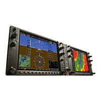
Garmin G1000:Socata Pilot's Manual (542 pages)
Integrated Flight Deck Socata TBM 850
Brand:
Garmin
| Category:
Avionics Display
| Size: 40.93 MB
Table of Contents
Table of Contents
7
Section 1 System Overview
11
System Description
11
Line Replaceable Units (LRU)
12
G1000 Controls
17
PFD Controls
17
Controls Associated with the MFD
19
AFCS Controls
20
Audio Panel Controls
22
Secure Digital Cards
24
System Power-Up
25
System Operation
26
Normal Operation
26
Reversionary Mode
26
G1000 System Annunciations
29
Softkey Function
30
GPS Receiver Operation
35
Accessing G1000 Functionality
39
Menus
39
Mfd Page Groups
40
Mfd System Pages
44
Display Backlighting
52
Automatic Adjustment
52
Manual Adjustment
52
Section 2 Flight Instruments
55
Flight Instruments
55
Airspeed Indicator
58
Vspeed Reference
58
Attitude Indicator
60
Altimeter
62
Radar Altimeter
65
Vertical Speed Indicator (VSI)
66
Radar Height
66
Vertical Deviation
67
Horizontal Situation Indicator (HSI)
68
Selected Heading
69
Course Deviation Indicator (CDI)
73
Supplemental Flight Data
81
Temperature Displays
81
Wind Data
82
Vertical Navigation (VNV) Indications
83
PFD Annunciations and Alerting Functions
84
System Alerting
84
TraffiC Annunciation
85
TAWS Annunciations
85
Altitude Alerting
86
Low Altitude Annunciation
86
Minimum Descent Altitude/Decision Height Alerting
87
Marker Beacon Annunciations
88
Abnormal Operations
89
Abnormal GPS Conditions
89
Unusual Attitudes
90
Wind Data
90
Inset Map
90
DME Information Window
90
Flight Plan Window
90
Minimum Descent Altitude
90
Decision Height
90
Selected Course
90
Section 3 Engine and Airframe Systems
91
Engine Indication System (EIS)
93
Engine Parameters
94
Cabin Pressurization
96
Fuel Information
96
Electrical Information
97
Trim and Flap Indicators
97
Synoptics
98
Electrical System
99
Fuel System
101
General Systems
102
Crew Alerting System (CAS)
103
CAS Messages and Prioritization
104
CAS Display Inhibits
106
Section 4 Audio Panel and Cns
107
Overview
107
Audio Panel Volume Control
107
PFD Controls and Frequency Display
108
Audio Panel Controls
110
COM Operation
112
COM Transceiver Selection and Activation
112
COM Transceiver Manual Tuning
113
Quick-Tuning and Activating 121.500 Mhz
114
Auto-Tuning the COM Frequency
115
Frequency Spacing
120
Automatic Squelch
121
Volume
121
NAV Operation
122
NAV Radio Selection and Activation
122
NAV Receiver Manual Tuning
123
Auto-Tuning a NAV Frequency from the MFD
125
Marker Beacon Receiver
130
ADF/DME Tuning
131
GTX 33/33D Mode S Transponders
135
Transponder Controls
135
Transponder Mode Selection
136
Entering a Transponder Code
139
IDENT Function
140
Flight ID Reporting
141
Additional Audio Panel Functions
142
Power-Up
142
Mono/Stereo Headsets
142
Speaker
142
Intercom
143
Passenger Address (PA) System
144
Simultaneous COM Operation
144
Clearance Recorder and Player
145
Entertainment Inputs
146
Audio Panels Preflight Procedure
147
Abnormal Operation
149
Stuck Microphone
149
COM Tuning Failure
149
PFD Failure, Dual System
150
Audio Panel Fail-Safe Operation
151
Reversionary Mode
151
Section 5 Flight Management
153
Introduction
153
Navigation Status Box
155
Using Map Displays
156
Map Orientation
156
Map Range
158
Map Panning
161
Measuring Bearing and Distance
166
Topography
167
Map Symbols
170
Airways
176
Track Vector
178
Wind Vector
179
Nav Range Ring
180
Fuel Range Ring
181
Waypoints
182
Airports
183
Intersections
189
Ndbs
191
Vors
193
User Waypoints
195
Airspaces
200
Direct-To-Navigation
205
Flight Planning
211
Flight Plan Creation
212
Adding Waypoints to an Existing Flight Plan
215
Adding Airways to a Flight Plan
217
Adding Procedures to a Stored Flight Plan
220
Flight Plan Storage
226
Flight Plan Editing
229
Along Track Offsets
232
Parallel Track
234
Activating a Flight Plan Leg
237
Inverting a Flight Plan
238
Flight Plan Views
239
Closest Point of FPL
241
Vertical Navigation
242
Altitude Constraints
244
Procedures
248
Departures
248
Arrivals
251
Approaches
253
Trip Planning
259
Weight Planning
263
Weight Caution and Warning Conditions
265
RAIM Prediction
266
Navigating a Flight Plan
270
Abnormal Operation
298
Section 6 Hazard Avoidance
301
XM Satellite Weather
301
Using XM SATELLITE Weather Products
303
Weather Softkeys on the Weather Data Link Page
306
Airborne Color Weather Radar
329
System Description
329
Principles of Pulsed Airborne Weather Radar
329
Safe Operating Distance
334
Basic Antenna Tilt Setup
334
Weather Mapping and Interpretation
336
Ground Mapping and Interpretation
349
Stormscope (Optional)
350
Setting up Stormscope on the Navigation Map
350
Selecting the Stormscope Page
354
Terrain Proximity
357
Displaying Terrain Proximity Data
358
Terrain Proximity Page
360
Terrain Awareness & Warning System (TAWS)
362
Displaying TAWS Data
363
TAWS Page
365
TAWS Alerts
367
System Status
374
TraffiC Advisory System (TAS)
376
TAS Symbology
376
Operation
377
Altitude Display
379
TraffiC Map Page Display Range
380
TAS Alerts
382
System Status
382
Section 7 Automatic Flight Control System
385
Flight Director Operation
388
Activating the Flight Director
388
AFCS Status Box
389
Flight Director Modes
390
Switching Flight Directors
390
Command Bars
391
Vertical Modes
392
Pitch Hold Mode (PIT)
393
Selected Altitude Capture Mode (ALTS)
394
Altitude Hold Mode (ALT)
395
Vertical Speed Mode (VS)
396
Flight Level Change Mode (FLC)
397
Vertical Navigation Modes (VPTH, ALTV)
399
Glidepath Mode (GP)
404
Glideslope Mode (GS)
405
Takeoff (TO) and Go Around (GA) Modes
406
Lateral Modes
407
Roll Hold Mode (ROL)
408
Low Bank Mode
408
Heading Select Mode (HDG)
409
Navigation Mode (GPS, VOR, LOC)
410
Approach Mode (GPS, VAPP, LOC)
412
Backcourse Mode (BC)
414
Autopilot and Yaw Damper Operation
415
Flight Control
415
Engagement
416
Control Wheel Steering
416
Disengagement
417
Example Flight Plan
418
Departure
419
Intercepting a vor Radial
421
Flying a Flight Plan/Gps Course
422
Descent
423
Approach
427
Go Around/Missed Approach
429
AFCS Annunciations and Alerts
431
AFCS Status Alerts
431
Overspeed Protection
432
Section 8 Additional Features
433
Safetaxi
433
Safetaxi Cycle Number and Revision
436
Chartview
439
Chartview Softkeys
439
Terminal Procedures Charts
440
Chart Options
450
Day/Night View
456
Chartview Cycle Number and Expiration Date
458
Flitecharts
462
Flitecharts Softkeys
462
Terminal Procedures Charts
463
Chart Options
471
Day/Night View
475
Flitecharts Cycle Number and Expiration Date
477
XM Radio Entertainment (Optional)
481
Activating XM Satellite Radio Services
481
Using XM Radio
483
Scheduler
487
Electronic Checklists (Optional)
489
Abnormal Operation
492
Annunciations and Alerts
495
CAS Messages
495
Comparator Annunciations
497
Reversionary Sensor Annunciations
498
G1000 System Annunciations
498
G1000 System Message Advisories
501
AFCS Alerts
513
Taws Alerts
514
Other G1000 Aural Alerts
515
SD Card Use
517
Jeppesen Databases
517
Garmin Databases
518
Glossary
521
Frequently Asked Questions
527
Map Symbols
533
Advertisement
Advertisement
Related Products
Garmin G1000H
Garmin G1000:Piper
Garmin G1000 NXi
Garmin G1000 NAV III
Garmin G1000 Diamond DA62
Garmin GAP 26
Garmin GSU 75H
Garmin GEA 71
Garmin GIA 6300
Garmin GMA 1347D-00
Garmin Categories
GPS
Watch
Car Navigation system
Avionics Display
Marine GPS System
More Garmin Manuals
Login
Sign In
OR
Sign in with Facebook
Sign in with Google
Upload manual
Upload from disk
Upload from URL