Garmin GNS 530 Quick Reference
Hide thumbs
Also See for GNS 530:
- Pilot's manual & reference (289 pages) ,
- Pilot's manual and reference (282 pages) ,
- Installation manual (115 pages)
Table of Contents
Advertisement
Quick Links
Advertisement
Table of Contents

Related Manuals for Garmin GNS 530


Summary of Contents for Garmin GNS 530
- Page 1 GNS 530(A) Quick Reference...
-
Page 2: Left-Hand Keys And Knobs
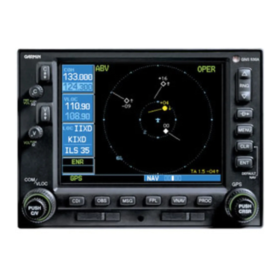
KEYS AND KNOBS Left-hANd KeyS ANd KNobS (1) COM Flip-flop Key – Swaps the active and standby COM frequencies. Press and hold to select emergency channel (121.500 MHz). (2) COM Power/Volume Knob – Controls unit power and communications radio volume. Press momentarily to disable automatic squelch control. -
Page 3: Bottom Row Keys
(11) ENT Key – Used to approve an operation or complete data entry. It is also used to confirm information during power on. (12) Small Right Knob – Used to select pages within the page groups. Press this knob momentarily to display the on-screen cursor. - Page 4 POWER ON The Instrument Panel Self-test Page allows the pilot to verify that the GNS 530 is communicating properly with in-panel instruments. Compare on-screen indications with the information depicted on connected instruments, such as the CDI, HSI, RMI, and/or external annunciators. After verifying proper operation, press the ENT Key to display the Satellite Status Page.
-
Page 5: Frequency Selection
Selecting a frequency: If the tuning cursor is not currently in the desired window (COM or VLOC), press the small left knob momentarily. Turn the large left knob to select the desired megahertz (MHz) value. For example, the ‘117’ portion of the frequency ‘117.70’. Turn the small left knob to select the desired kilohertz (kHz) value. -
Page 6: Wpt Page Group
MAIN PAGE GROUPS mAiN pAGe GRoUpS The GNS 530’ s main pages are divided into four separate page groups: NAV, WPT, AUX, and NRST. Each page group is comprised of multiple pages. The page groups are selected using the large right knob. The individual pages are selected using the small right knob. -
Page 7: Direct-To Navigation
AUX pAGe GRoUp The AUX Page Group includes three pages. Flight Planning Utility NOTE: The AUX Page Group may have four AUX pages available when the GNS 530 installation includes connection to a weather information source. NRSt pAGe GRoUp The NRST Page Group includes eight pages. NRST Intersection NRST NDB NRST Airport... - Page 8 DIRECT-TO NAVIGATION Selecting a direct-to destination from the Map Page: Select the Map Page from the NAV Page Group. Press the small right knob to display a panning pointer. Turn the small and large right knobs to place the panning pointer at the desired destination location.
- Page 9 Selecting a nearby airport or a flight plan waypoint as a direct-to destination: Press the Direct-to Key. Turn the large right knob to highlight the nearest airport (NRST) or flight plan (FPL) field. Turn the small right knob to display a window listing nearby airports or all waypoints in the active flight plan.
- Page 10 VIEWING AIRPORT INFORMATION Viewing airport information by facility name or city: Select the Airport Location Page (see page 6). Press the small right knob to activate the cursor. Turn the large right knob to highlight the facility name (second line) or the city (third line) field.
-
Page 11: Default Nav Page
defAULt NAV pAGe User-Selectable Data Fields (all four corners) Range Course Deviation Indicator (CDI) Position of Current Number of Pages in Page within Current Current Page Group Current Page Group Page Group The following symbols are used on the Default NAV Page (directly above the CDI), to depict the ‘active leg’... - Page 12 MAP PAGE Turn the small right knob to display the list of available data items. Continue turning the small right knob to select the desired data item from the list. Press the ENT Key to select the desired data item and return to the Default NAV Page. Press the small right knob momentarily to remove the cursor from the page.
- Page 13 Quickly decluttering the Map Display: Press the CLR Key momentarily (as often as needed) to select the desired amount of map detail. Map Detail Level Turning on the Map Page data fields: With the Map Page displayed, press the MENU Key to display an options menu.
-
Page 14: Nav/Com Page
INHIBITING TAWS OR TERRAIN Inhibiting TAWS or TERRAIN: Select the TAWS or TERRAIN Page and press the MENU Key. ‘Inhibit Terrain?’ is selected by default. Press the ENT Key. The ‘TER INHB’ annunciation is displayed in the annunciator field when TAWS or TERRAIN is inhibited. -
Page 15: Nearest Airports
Scrolling through the list of frequencies: Activate the cursor, if not already active, by pressing the small right knob. Turn the large right knob to move the cursor through the list of frequencies. If there are more frequencies in the list than can be displayed on the display, a scroll bar along the right-hand side of the display indicates which part of the list is currently being displayed. - Page 16 NEARBY AIRPORTS Viewing additional information for a nearby airport: Highlight the identifier of the desired airport by scrolling through the list, as described in the preceding procedure. Press the ENT Key to display the Airport Location Page for the selected airport. To view additional WPT pages for the selected airport (including the airport runway and airport frequency pages), press the small right...
-
Page 17: Creating A New Flight Plan
Creating a new flight plan: Press the FPL Key and turn the small right knob to display the Flight Plan Catalog Page. Press the MENU Key to display the Flight Plan Catalog Page Menu. Turn the large right knob to highlight ‘Create New Flight Plan?’... -
Page 18: Selecting An Approach
SELECT AN APPROACH Editing a flight plan: Press the FPL Key and turn the small right knob to display the Flight Plan Catalog Page. Press the small right knob to activate the cursor. Turn the large right knob to highlight the desired flight plan and press the ENT Key. - Page 19 Turn the large right knob to highlight ‘Load?’ or ‘Activate?’ and press the ENT Key. ‘Load?’ adds the procedure to the flight plan without immediately using it for navigation guidance. This allows the pilot to continue navigating the original flight plan, but keeps the procedure available on the Active Flight Plan Page for quick activation when needed.
-
Page 20: Flying An Approach
FLYING AN APPROACH Activating the approach with vectors to final: With an approach loaded in the active flight plan, press the PROC Key to display the Procedures Page. Turn the large right knob to highlight ‘Activate Vector-To-Final?’ and press the ENT Key. GUideLiNeS foR fLyiNG AN AppRoACh Due to the variety of available approach procedures, the specific steps required will vary according to the... -
Page 21: Flying The Missed Approach
• The CDI will guide the pilot through a DME arc. Just keep the needle centered to fly along the arc. When using an autopilot, the course select on the CDI (or HSI) must be periodically updated with the desired track (DTK). •... - Page 22 Hounsdown Business Park Southampton, SO40 9RB, U.K. p: +44/ (0) 870.8501241 f: +44/ (0) 870.8501251 Garmin Corporation No. 68, Jangshu 2nd Road Shijr, Taipei County, Taiwan p: 886/2.2642.9199 f: 886/2.2642.9099 www.garmin.com © 2008 Garmin Ltd. or its subsidiaries 190-00181-01 Rev. G...